Afton Topo Map Wyoming
To zoom in, hover over the map of Afton
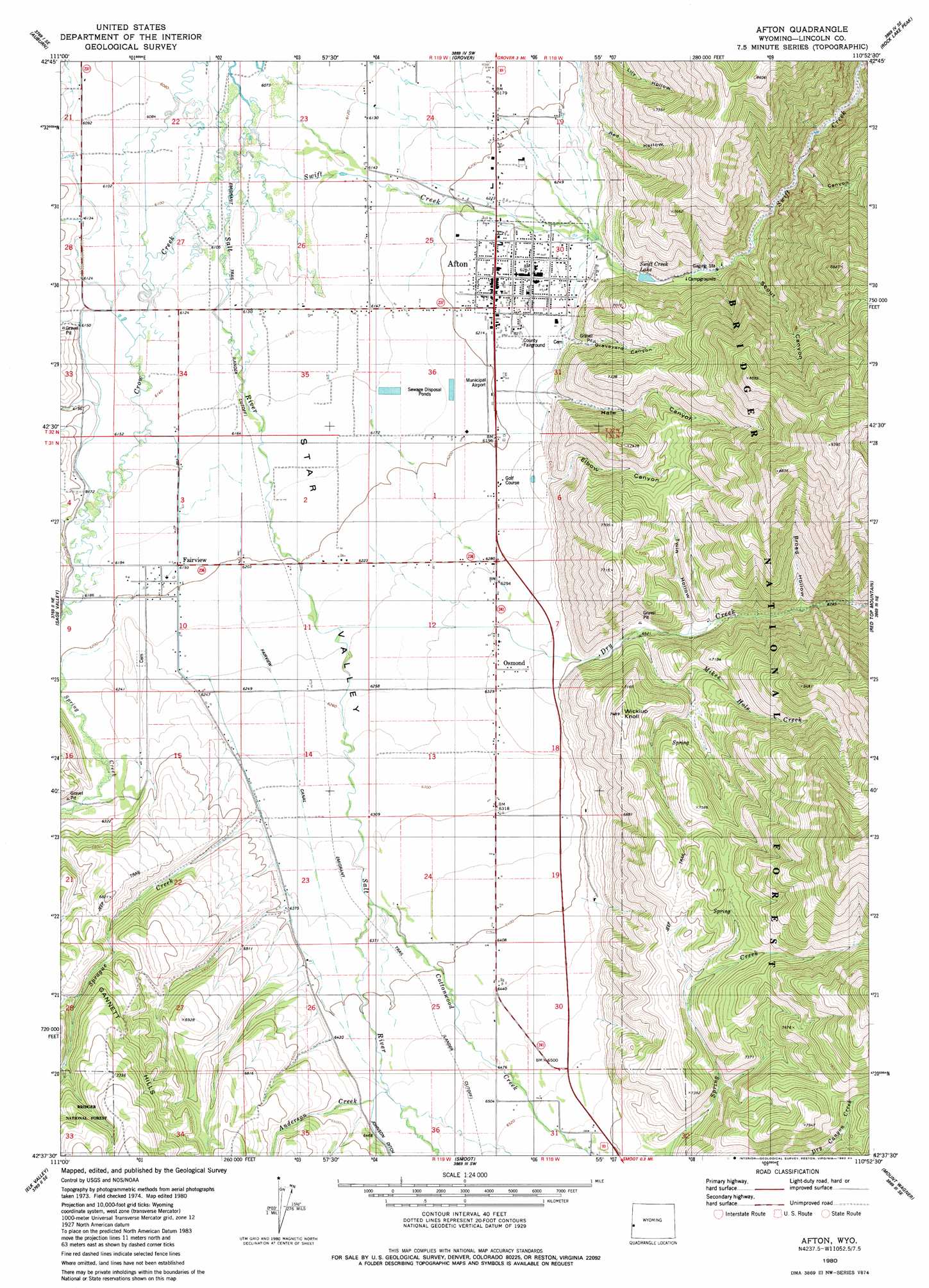
USGS Topo Quad 42110f8 - 1:24,000 scale
| Topo Map Name: | Afton |
| USGS Topo Quad ID: | 42110f8 |
| Print Size: | ca. 21 1/4" wide x 27" high |
| Southeast Coordinates: | 42.625° N latitude / 110.875° W longitude |
| Map Center Coordinates: | 42.6875° N latitude / 110.9375° W longitude |
| U.S. State: | WY |
| Filename: | o42110f8.jpg |
| Download Map JPG Image: | Afton topo map 1:24,000 scale |
| Map Type: | Topographic |
| Topo Series: | 7.5´ |
| Map Scale: | 1:24,000 |
| Source of Map Images: | United States Geological Survey (USGS) |
| Alternate Map Versions: |
Afton WY 1980, updated 1984 Download PDF Buy paper map Afton WY 2012 Download PDF Buy paper map Afton WY 2015 Download PDF Buy paper map |
| FStopo: | US Forest Service topo Afton is available: Download FStopo PDF Download FStopo TIF |
1:24,000 Topo Quads surrounding Afton
Stump Peak |
Thayne West |
Thayne East |
Man Peak |
Blind Bull Creek |
Diamond Flat |
Auburn |
Grover |
Rock Lake Peak |
Park Creek |
Stewart Flat |
Sage Valley |
Afton |
Red Top Mountain |
Box Canyon Creek |
Snowdrift Mountain |
Elk Valley |
Smoot |
Mount Wagner |
Poison Meadows |
Meade Peak |
Giraffe Creek |
Salt Flat |
Porcupine Creek |
Graham Peak |
> Back to 42110e1 at 1:100,000 scale
> Back to 42110a1 at 1:250,000 scale
> Back to U.S. Topo Maps home
Afton topo map: Gazetteer
Afton: Airports
Afton Municipal Airport elevation 1897m 6223′Afton: Canals
Fairview Canal elevation 1910m 6266′Afton: Dams
Afton Electric Dam elevation 1968m 6456′Afton: Mines
Swift Creek Area Mine elevation 1905m 6250′Afton: Populated Places
Afton elevation 1902m 6240′Fairview elevation 1892m 6207′
Osmond Community elevation 1929m 6328′
Afton: Reservoirs
Afton Electric Reservoir elevation 1968m 6456′Swift Creek Lake elevation 1944m 6377′
Afton: Streams
Anderson Creek elevation 1965m 6446′Child Creek elevation 1876m 6154′
Cottonwood Creek elevation 1934m 6345′
Crow Creek elevation 1851m 6072′
Dry Creek elevation 1900m 6233′
Harmony Creek elevation 1872m 6141′
Mikes Hole Creek elevation 1983m 6505′
Richardson Creek elevation 1875m 6151′
Richardson Creek elevation 1875m 6151′
Sprague Creek elevation 1928m 6325′
Swift Creek elevation 1854m 6082′
Afton: Summits
Wickiup Knoll elevation 2255m 7398′Afton: Valleys
Broad Hollow elevation 2041m 6696′Elbow Canyon elevation 1946m 6384′
Graveyard Canyon elevation 1946m 6384′
Hale Canyon elevation 1980m 6496′
Red Hollow elevation 1937m 6354′
Scout Canyon elevation 1981m 6499′
Twin Hollow elevation 2001m 6564′
Y Canyon elevation 2028m 6653′
Afton digital topo map on disk
Buy this Afton topo map showing relief, roads, GPS coordinates and other geographical features, as a high-resolution digital map file on DVD: