Grover Topo Map Wyoming
To zoom in, hover over the map of Grover
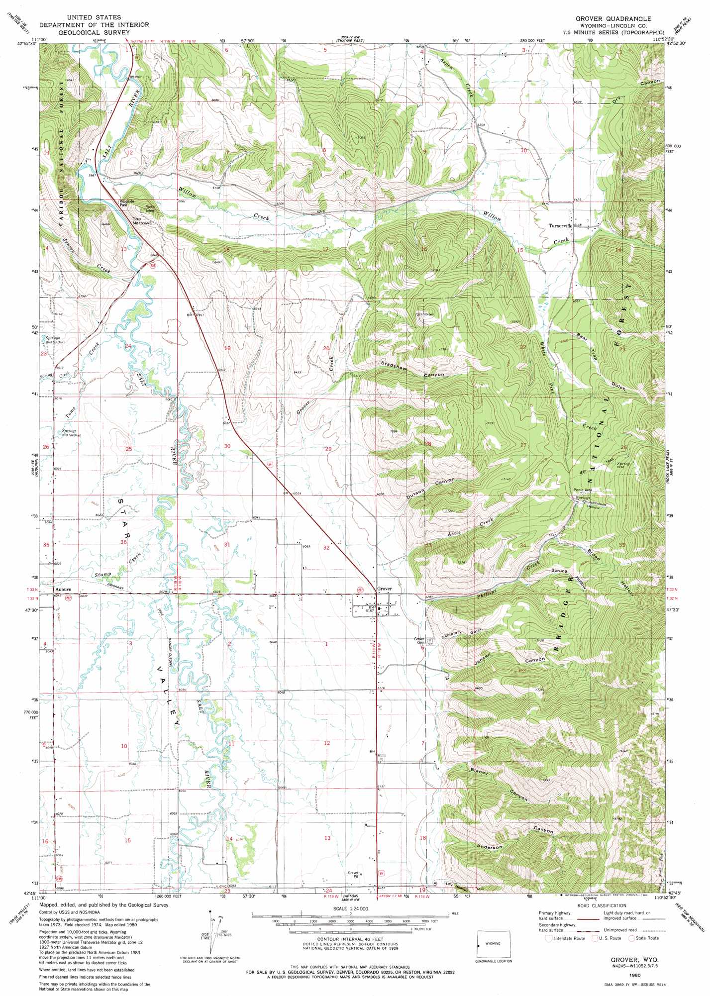
USGS Topo Quad 42110g8 - 1:24,000 scale
| Topo Map Name: | Grover |
| USGS Topo Quad ID: | 42110g8 |
| Print Size: | ca. 21 1/4" wide x 27" high |
| Southeast Coordinates: | 42.75° N latitude / 110.875° W longitude |
| Map Center Coordinates: | 42.8125° N latitude / 110.9375° W longitude |
| U.S. State: | WY |
| Filename: | o42110g8.jpg |
| Download Map JPG Image: | Grover topo map 1:24,000 scale |
| Map Type: | Topographic |
| Topo Series: | 7.5´ |
| Map Scale: | 1:24,000 |
| Source of Map Images: | United States Geological Survey (USGS) |
| Alternate Map Versions: |
Grover WY 1980, updated 1980 Download PDF Buy paper map Grover WY 2012 Download PDF Buy paper map Grover WY 2015 Download PDF Buy paper map |
| FStopo: | US Forest Service topo Grover is available: Download FStopo PDF Download FStopo TIF |
1:24,000 Topo Quads surrounding Grover
Tincup Mountain |
Etna |
Stewart Peak |
Deer Creek |
Pickle Pass |
Stump Peak |
Thayne West |
Thayne East |
Man Peak |
Blind Bull Creek |
Diamond Flat |
Auburn |
Grover |
Rock Lake Peak |
Park Creek |
Stewart Flat |
Sage Valley |
Afton |
Red Top Mountain |
Box Canyon Creek |
Snowdrift Mountain |
Elk Valley |
Smoot |
Mount Wagner |
Poison Meadows |
> Back to 42110e1 at 1:100,000 scale
> Back to 42110a1 at 1:250,000 scale
> Back to U.S. Topo Maps home
Grover topo map: Gazetteer
Grover: Airports
Heiner Airport elevation 1962m 6437′Grover: Gaps
The Narrows elevation 1850m 6069′Grover: Mines
Leefe Mine elevation 2159m 7083′Grover: Parks
Grover Park elevation 2141m 7024′Grover: Populated Places
Grover elevation 1874m 6148′Turnerville elevation 1953m 6407′
Grover: Streams
Astle Creek elevation 1880m 6167′Crow Creek elevation 1849m 6066′
Grover Creek elevation 1831m 6007′
Jensen Creek elevation 1845m 6053′
North Fork Swift Creek elevation 2056m 6745′
Phillips Creek elevation 1888m 6194′
Spring Creek elevation 1830m 6003′
Stump Creek elevation 1836m 6023′
Toms Creek elevation 1828m 5997′
Water Creek elevation 1834m 6017′
White Pine Creek elevation 1945m 6381′
Willow Creek elevation 1820m 5971′
Grover: Valleys
Anderson Canyon elevation 1896m 6220′Bear Trap Gulch elevation 2001m 6564′
Blaney Canyon elevation 1891m 6204′
Bradshaw Canyon elevation 1939m 6361′
Broad Hollow elevation 2057m 6748′
Cemetery Gulch elevation 1890m 6200′
Churchhouse Hollow elevation 2113m 6932′
Dry Canyon elevation 1973m 6473′
Dutson Canyon elevation 1890m 6200′
Jensen Canyon elevation 1889m 6197′
Lily Hollow elevation 1918m 6292′
Spruce Hollow elevation 1970m 6463′
Grover digital topo map on disk
Buy this Grover topo map showing relief, roads, GPS coordinates and other geographical features, as a high-resolution digital map file on DVD: