Bear Lake North Topo Map Idaho
To zoom in, hover over the map of Bear Lake North
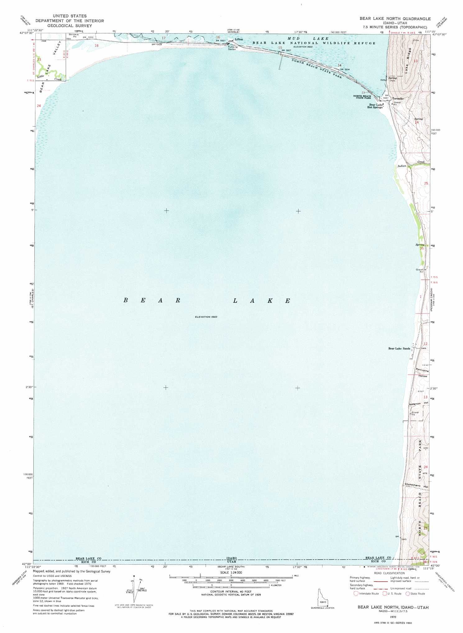
USGS Topo Quad 42111a3 - 1:24,000 scale
| Topo Map Name: | Bear Lake North |
| USGS Topo Quad ID: | 42111a3 |
| Print Size: | ca. 21 1/4" wide x 27" high |
| Southeast Coordinates: | 42° N latitude / 111.25° W longitude |
| Map Center Coordinates: | 42.0625° N latitude / 111.3125° W longitude |
| U.S. States: | ID, UT |
| Filename: | o42111a3.jpg |
| Download Map JPG Image: | Bear Lake North topo map 1:24,000 scale |
| Map Type: | Topographic |
| Topo Series: | 7.5´ |
| Map Scale: | 1:24,000 |
| Source of Map Images: | United States Geological Survey (USGS) |
| Alternate Map Versions: |
Bear Lake North ID 1970, updated 1973 Download PDF Buy paper map Bear Lake North ID 1977, updated 1980 Download PDF Buy paper map Bear Lake North ID 2011 Download PDF Buy paper map Bear Lake North ID 2013 Download PDF Buy paper map |
1:24,000 Topo Quads surrounding Bear Lake North
Midnight Mountain |
Ovid |
Montpelier |
Montpelier Canyon |
Geneva |
Paris Peak |
Paris |
Dingle |
Pegram |
Border |
Egan Basin |
Saint Charles |
Bear Lake North |
Pegram Creek |
Boundary Ridge |
Tony Grove Creek |
Garden City |
Bear Lake South |
Sheeppen Creek |
South Lake |
Temple Peak |
Meadowville |
Laketown |
Sage Creek |
Leefe |
> Back to 42111a1 at 1:100,000 scale
> Back to 42110a1 at 1:250,000 scale
> Back to U.S. Topo Maps home
Bear Lake North topo map: Gazetteer
Bear Lake North: Parks
North Beach State Park elevation 1920m 6299′Bear Lake North: Populated Places
Bear Lake Hot Springs elevation 1814m 5951′Bear Lake Sands elevation 1825m 5987′
Lifton elevation 1807m 5928′
Turnpike elevation 1816m 5958′
Bear Lake North: Reservoirs
Bear Lake elevation 1807m 5928′Bear Lake North: Streams
Indian Creek elevation 1808m 5931′Little Creek elevation 1807m 5928′
Bear Lake North: Valleys
Bee Hunt Hollow elevation 1819m 5967′Chokecherry Hollow elevation 1816m 5958′
Cooley Canyon elevation 1821m 5974′
Peterson Hollow elevation 1820m 5971′
Porcupine Hollow elevation 1820m 5971′
Bear Lake North digital topo map on disk
Buy this Bear Lake North topo map showing relief, roads, GPS coordinates and other geographical features, as a high-resolution digital map file on DVD: