Egan Basin Topo Map Idaho
To zoom in, hover over the map of Egan Basin
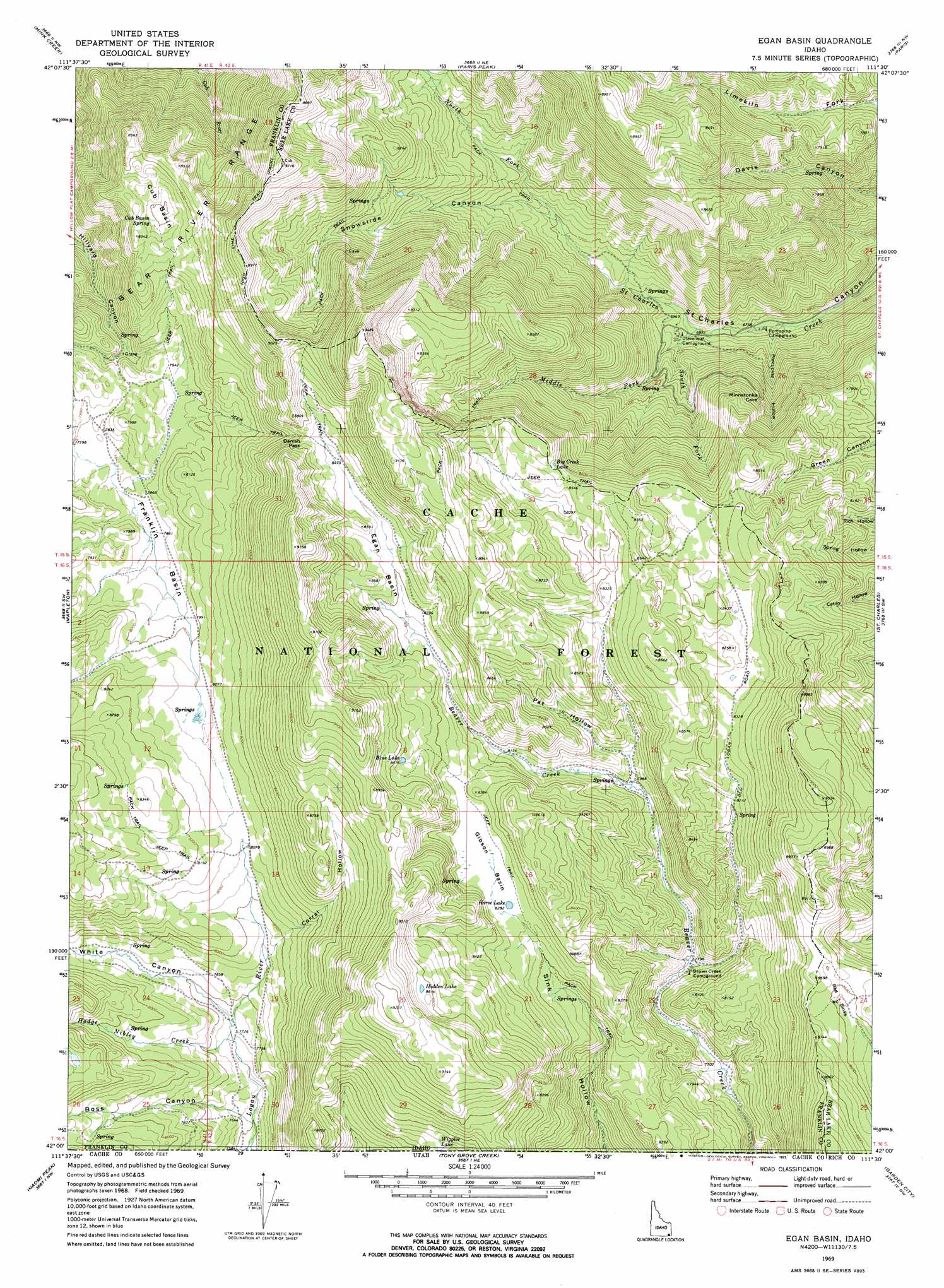
USGS Topo Quad 42111a5 - 1:24,000 scale
| Topo Map Name: | Egan Basin |
| USGS Topo Quad ID: | 42111a5 |
| Print Size: | ca. 21 1/4" wide x 27" high |
| Southeast Coordinates: | 42° N latitude / 111.5° W longitude |
| Map Center Coordinates: | 42.0625° N latitude / 111.5625° W longitude |
| U.S. State: | ID |
| Filename: | o42111a5.jpg |
| Download Map JPG Image: | Egan Basin topo map 1:24,000 scale |
| Map Type: | Topographic |
| Topo Series: | 7.5´ |
| Map Scale: | 1:24,000 |
| Source of Map Images: | United States Geological Survey (USGS) |
| Alternate Map Versions: |
Egan Basin ID 1969, updated 1973 Download PDF Buy paper map Egan Basin ID 1969, updated 1973 Download PDF Buy paper map Egan Basin ID 2005, updated 2007 Download PDF Buy paper map Egan Basin ID 2011 Download PDF Buy paper map Egan Basin ID 2013 Download PDF Buy paper map |
| FStopo: | US Forest Service topo Egan Basin is available: Download FStopo PDF Download FStopo TIF |
1:24,000 Topo Quads surrounding Egan Basin
Treasureton |
Oneida Narrows Reservoir |
Midnight Mountain |
Ovid |
Montpelier |
Riverdale |
Mink Creek |
Paris Peak |
Paris |
Dingle |
Franklin |
Mapleton |
Egan Basin |
Saint Charles |
Bear Lake North |
Richmond |
Naomi Peak |
Tony Grove Creek |
Garden City |
Bear Lake South |
Smithfield |
Mount Elmer |
Temple Peak |
Meadowville |
Laketown |
> Back to 42111a1 at 1:100,000 scale
> Back to 42110a1 at 1:250,000 scale
> Back to U.S. Topo Maps home
Egan Basin topo map: Gazetteer
Egan Basin: Basins
Cub Basin elevation 2514m 8248′Egan Basin elevation 2575m 8448′
Franklin Basin elevation 2399m 7870′
Gibson Basin elevation 2529m 8297′
Red Sinks elevation 2611m 8566′
Egan Basin: Gaps
Danish Pass elevation 2591m 8500′Egan Basin: Lakes
Big Creek Lake elevation 2609m 8559′Blue Lake elevation 2597m 8520′
Hidden Lake elevation 2692m 8832′
Horse Lake elevation 2528m 8293′
Wiggler Lake elevation 2597m 8520′
Egan Basin: Springs
Cub Basin Spring elevation 2514m 8248′Red Pine Spring elevation 2614m 8576′
Egan Basin: Streams
Hodge Nibley Creek elevation 2353m 7719′Middle Fork Saint Charles Creek elevation 2090m 6856′
North Fork Saint Charles Creek elevation 2090m 6856′
South Fork Saint Charles Creek elevation 2089m 6853′
Egan Basin: Valleys
Boss Canyon elevation 2344m 7690′Corral Hollow elevation 2440m 8005′
Pat Hollow elevation 2451m 8041′
Porcupine Hollow elevation 2063m 6768′
Snowslide Canyon elevation 2091m 6860′
White Canyon elevation 2362m 7749′
Egan Basin digital topo map on disk
Buy this Egan Basin topo map showing relief, roads, GPS coordinates and other geographical features, as a high-resolution digital map file on DVD: