Snowdrift Mountain Topo Map Idaho
To zoom in, hover over the map of Snowdrift Mountain
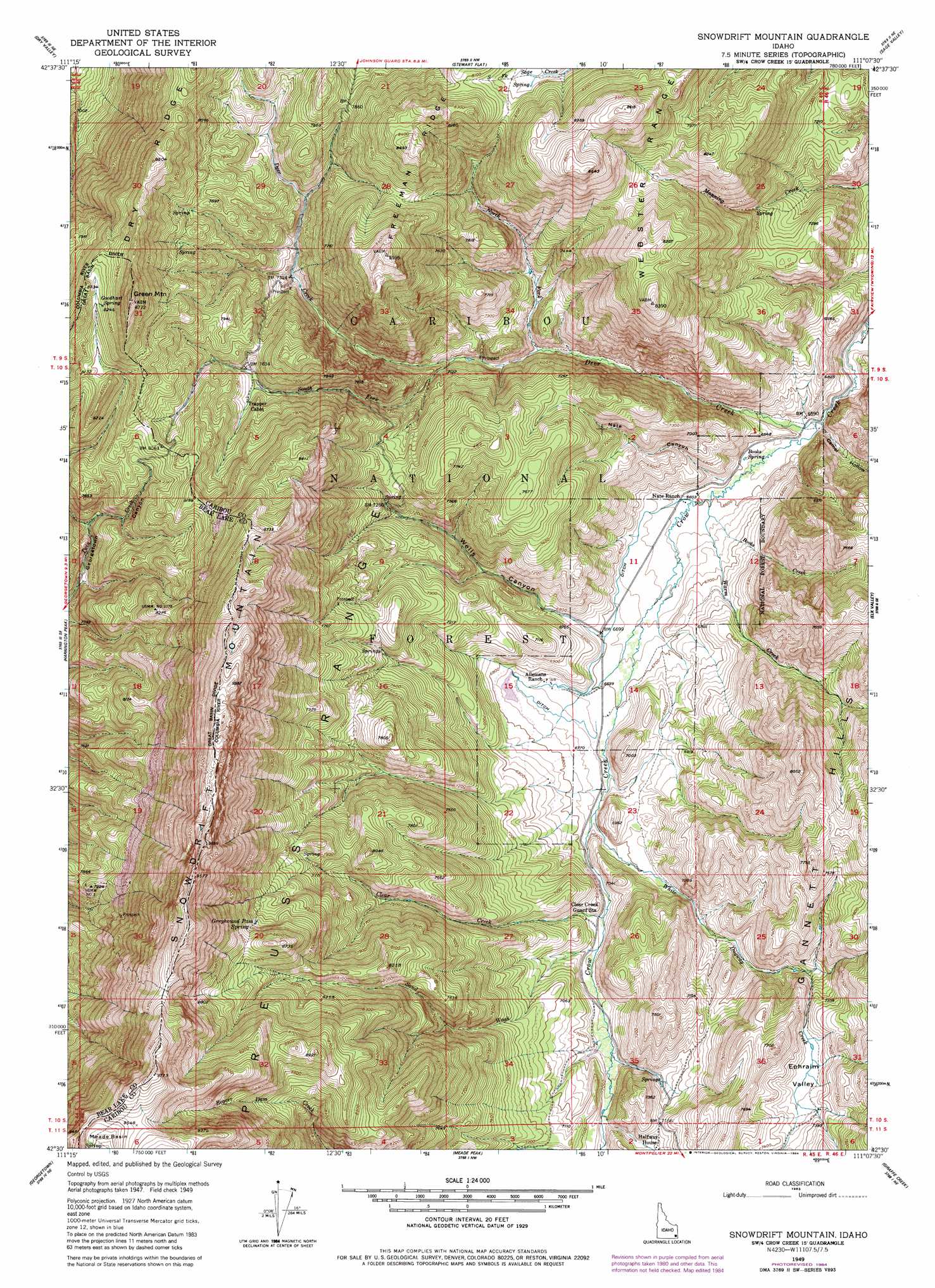
USGS Topo Quad 42111e2 - 1:24,000 scale
| Topo Map Name: | Snowdrift Mountain |
| USGS Topo Quad ID: | 42111e2 |
| Print Size: | ca. 21 1/4" wide x 27" high |
| Southeast Coordinates: | 42.5° N latitude / 111.125° W longitude |
| Map Center Coordinates: | 42.5625° N latitude / 111.1875° W longitude |
| U.S. State: | ID |
| Filename: | o42111e2.jpg |
| Download Map JPG Image: | Snowdrift Mountain topo map 1:24,000 scale |
| Map Type: | Topographic |
| Topo Series: | 7.5´ |
| Map Scale: | 1:24,000 |
| Source of Map Images: | United States Geological Survey (USGS) |
| Alternate Map Versions: |
Snowdrift Mountain ID 1949, updated 1963 Download PDF Buy paper map Snowdrift Mountain ID 1949, updated 1981 Download PDF Buy paper map Snowdrift Mountain ID 1949, updated 1984 Download PDF Buy paper map Snowdrift Mountain ID 1951 Download PDF Buy paper map Snowdrift Mountain ID 2011 Download PDF Buy paper map Snowdrift Mountain ID 2013 Download PDF Buy paper map |
| FStopo: | US Forest Service topo Snowdrift Mountain is available: Download FStopo PDF Download FStopo TIF |
1:24,000 Topo Quads surrounding Snowdrift Mountain
Lower Valley |
Upper Valley |
Diamond Flat |
Auburn |
Grover |
Johnson Creek |
Dry Valley |
Stewart Flat |
Sage Valley |
Afton |
Fossil Canyon |
Harrington Peak |
Snowdrift Mountain |
Elk Valley |
Smoot |
Nounan |
Georgetown |
Meade Peak |
Giraffe Creek |
Salt Flat |
Ovid |
Montpelier |
Montpelier Canyon |
Geneva |
Huff Lake |
> Back to 42111e1 at 1:100,000 scale
> Back to 42110a1 at 1:250,000 scale
> Back to U.S. Topo Maps home
Snowdrift Mountain topo map: Gazetteer
Snowdrift Mountain: Basins
Ephraim Valley elevation 2231m 7319′Meade Basin elevation 2867m 9406′
Snowdrift Mountain: Ranges
Snowdrift Mountain elevation 2852m 9356′Snowdrift Mountain: Springs
Books Spring elevation 2010m 6594′Goodhart Spring elevation 2508m 8228′
Greyhound Pass Spring elevation 2538m 8326′
Snowdrift Mountain: Streams
Books Creek elevation 2016m 6614′Clear Creek elevation 2088m 6850′
Deer Creek elevation 2000m 6561′
North Fork Deer Creek elevation 2096m 6876′
Sand Wash elevation 2100m 6889′
South Fork Deer Creek elevation 2127m 6978′
Warm Creek elevation 2013m 6604′
White Dugway Creek elevation 2058m 6751′
Snowdrift Mountain: Summits
Green Mountain elevation 2661m 8730′Snowdrift Mountain: Valleys
Camel Hollow elevation 2007m 6584′Nate Canyon elevation 2022m 6633′
Wells Canyon elevation 2043m 6702′
Snowdrift Mountain digital topo map on disk
Buy this Snowdrift Mountain topo map showing relief, roads, GPS coordinates and other geographical features, as a high-resolution digital map file on DVD: