Alexander Topo Map Idaho
To zoom in, hover over the map of Alexander
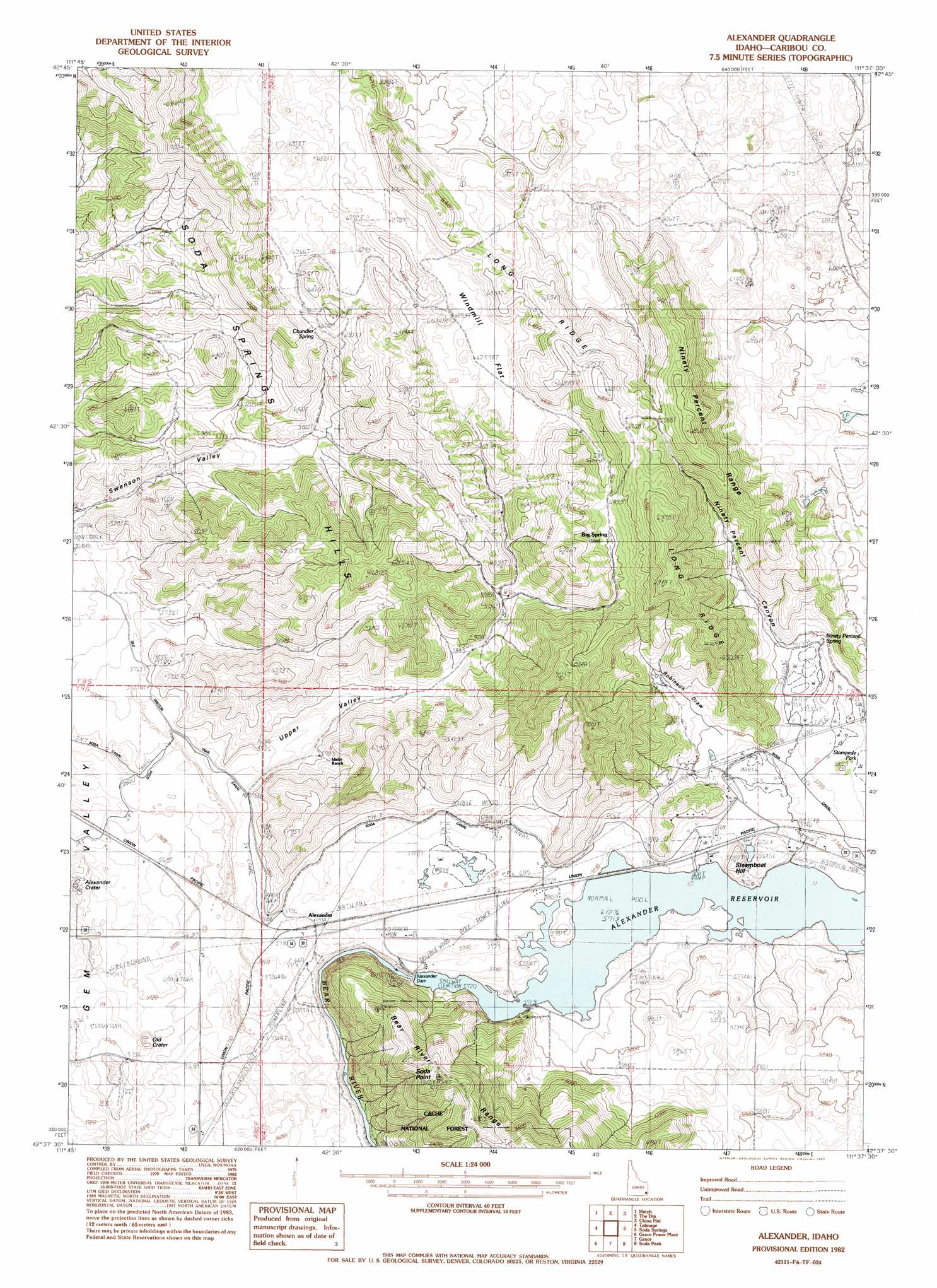
USGS Topo Quad 42111f6 - 1:24,000 scale
| Topo Map Name: | Alexander |
| USGS Topo Quad ID: | 42111f6 |
| Print Size: | ca. 21 1/4" wide x 27" high |
| Southeast Coordinates: | 42.625° N latitude / 111.625° W longitude |
| Map Center Coordinates: | 42.6875° N latitude / 111.6875° W longitude |
| U.S. State: | ID |
| Filename: | o42111f6.jpg |
| Download Map JPG Image: | Alexander topo map 1:24,000 scale |
| Map Type: | Topographic |
| Topo Series: | 7.5´ |
| Map Scale: | 1:24,000 |
| Source of Map Images: | United States Geological Survey (USGS) |
| Alternate Map Versions: |
Alexander ID 1982, updated 1982 Download PDF Buy paper map Alexander ID 2005, updated 2007 Download PDF Buy paper map Alexander ID 2011 Download PDF Buy paper map Alexander ID 2013 Download PDF Buy paper map |
| FStopo: | US Forest Service topo Alexander is available: Download FStopo PDF Download FStopo TIF |
1:24,000 Topo Quads surrounding Alexander
Chesterfield Res |
Grizzly Creek |
Reservoir Mountain |
Henry |
Wayan West |
Chesterfield |
Hatch |
The Dip |
China Hat |
Lower Valley |
Bancroft |
Talmage |
Alexander |
Soda Springs |
Johnson Creek |
Sedgwick Peak |
Grace Power Plant |
Grace |
Soda Peak |
Fossil Canyon |
Cottonwood Peak |
Thatcher Hill |
Thatcher |
North Canyon |
Nounan |
> Back to 42111e1 at 1:100,000 scale
> Back to 42110a1 at 1:250,000 scale
> Back to U.S. Topo Maps home
Alexander topo map: Gazetteer
Alexander: Cliffs
Soda Point elevation 1993m 6538′Alexander: Dams
Alexander Dam elevation 1743m 5718′Soda Dam elevation 1737m 5698′
Alexander: Flats
Stampede Park elevation 1756m 5761′Windmill Flat elevation 1908m 6259′
Alexander: Populated Places
Alexander elevation 1748m 5734′Alexander: Ranges
Ninety Percent Range elevation 2073m 6801′Soda Springs Hills elevation 2042m 6699′
Alexander: Reservoirs
Alexander Reservoir elevation 1741m 5711′Alexander: Ridges
Long Ridge elevation 2073m 6801′Alexander: Springs
Big Spring elevation 1951m 6400′Chandler Spring elevation 1906m 6253′
Ninety Percent Spring elevation 1766m 5793′
Steamboat Spring elevation 1750m 5741′
Alexander: Summits
Steamboat Hill elevation 1787m 5862′Alexander: Valleys
Ninety Percent Canyon elevation 1786m 5859′Robinson Draw elevation 1764m 5787′
Upper Valley elevation 1745m 5725′
Alexander digital topo map on disk
Buy this Alexander topo map showing relief, roads, GPS coordinates and other geographical features, as a high-resolution digital map file on DVD: