Grizzly Creek Topo Map Idaho
To zoom in, hover over the map of Grizzly Creek
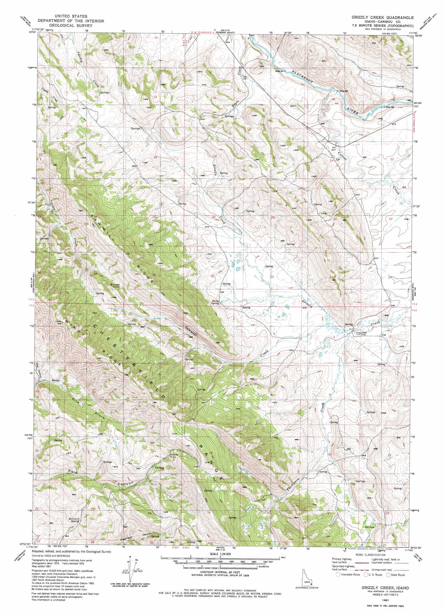
USGS Topo Quad 42111h7 - 1:24,000 scale
| Topo Map Name: | Grizzly Creek |
| USGS Topo Quad ID: | 42111h7 |
| Print Size: | ca. 21 1/4" wide x 27" high |
| Southeast Coordinates: | 42.875° N latitude / 111.75° W longitude |
| Map Center Coordinates: | 42.9375° N latitude / 111.8125° W longitude |
| U.S. State: | ID |
| Filename: | o42111h7.jpg |
| Download Map JPG Image: | Grizzly Creek topo map 1:24,000 scale |
| Map Type: | Topographic |
| Topo Series: | 7.5´ |
| Map Scale: | 1:24,000 |
| Source of Map Images: | United States Geological Survey (USGS) |
| Alternate Map Versions: |
Grizzly Creek ID 1981, updated 1982 Download PDF Buy paper map Grizzly Creek ID 2010 Download PDF Buy paper map Grizzly Creek ID 2013 Download PDF Buy paper map |
1:24,000 Topo Quads surrounding Grizzly Creek
Higham Peak |
Miner Creek |
Poison Creek |
Long Valley |
Homer Valley |
Lincoln Peak |
Dunn Basin |
Paradise Valley |
Meadow Creek Mountain |
Little Valley Hills |
Jeff Cabin Creek |
Chesterfield Res |
Grizzly Creek |
Reservoir Mountain |
Henry |
Bear Camp Gulch |
Chesterfield |
Hatch |
The Dip |
China Hat |
Haystack Mountain |
Bancroft |
Talmage |
Alexander |
Soda Springs |
> Back to 42111e1 at 1:100,000 scale
> Back to 42110a1 at 1:250,000 scale
> Back to U.S. Topo Maps home
Grizzly Creek topo map: Gazetteer
Grizzly Creek: Gaps
Devils Gate elevation 2073m 6801′Swaps Pass elevation 2054m 6738′
Grizzly Creek: Ridges
Sawmill Ridge elevation 2146m 7040′Windy Ridge elevation 2180m 7152′
Grizzly Creek: Springs
Dairy Springs elevation 1876m 6154′Millward Spring elevation 1831m 6007′
Grizzly Creek: Streams
Corral Creek elevation 1814m 5951′Sawmill Creek elevation 1866m 6122′
Thompson Creek elevation 1862m 6108′
Grizzly Creek: Valleys
Dry Hollow elevation 1830m 6003′Grizzly Creek: Woods
Pine Grove elevation 1897m 6223′Grizzly Creek digital topo map on disk
Buy this Grizzly Creek topo map showing relief, roads, GPS coordinates and other geographical features, as a high-resolution digital map file on DVD: