Roy Topo Map Idaho
To zoom in, hover over the map of Roy
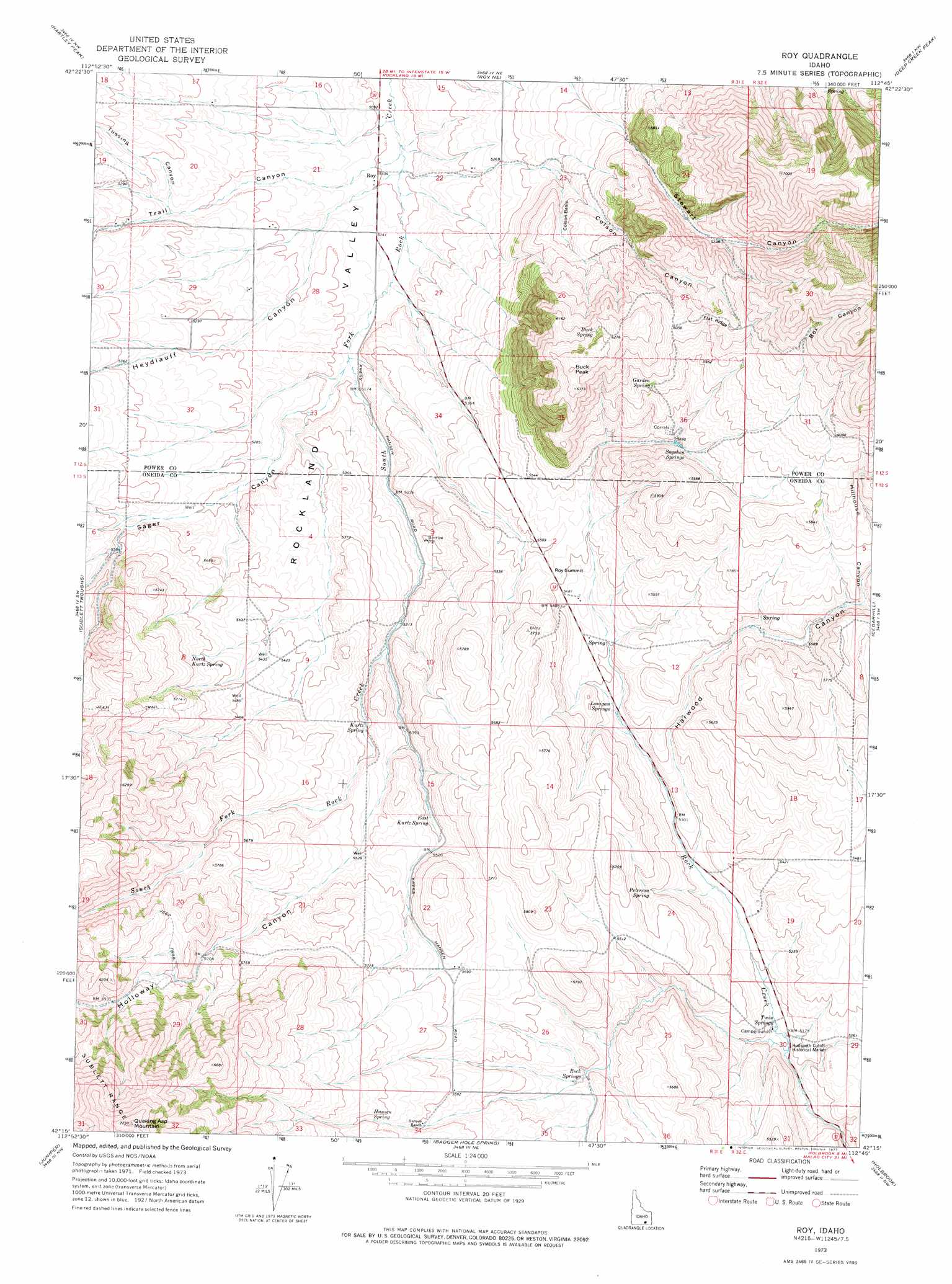
USGS Topo Quad 42112c7 - 1:24,000 scale
| Topo Map Name: | Roy |
| USGS Topo Quad ID: | 42112c7 |
| Print Size: | ca. 21 1/4" wide x 27" high |
| Southeast Coordinates: | 42.25° N latitude / 112.75° W longitude |
| Map Center Coordinates: | 42.3125° N latitude / 112.8125° W longitude |
| U.S. State: | ID |
| Filename: | o42112c7.jpg |
| Download Map JPG Image: | Roy topo map 1:24,000 scale |
| Map Type: | Topographic |
| Topo Series: | 7.5´ |
| Map Scale: | 1:24,000 |
| Source of Map Images: | United States Geological Survey (USGS) |
| Alternate Map Versions: |
Roy ID 1973, updated 1977 Download PDF Buy paper map Roy ID 2011 Download PDF Buy paper map Roy ID 2013 Download PDF Buy paper map |
| FStopo: | US Forest Service topo Roy is available: Download FStopo PDF Download FStopo TIF |
1:24,000 Topo Quads surrounding Roy
Badger Peak |
Rockland West |
Rockland East |
Bannock Peak |
Pauline |
North Heglar Canyon |
Hartley Peak |
Roy Ne |
Deep Creek Peak |
Arbon |
Sublett Reservoir |
Sublett Troughs |
Roy |
Cedarhill |
Buist |
Sweetzer Canyon |
Juniper |
Badger Hole Spring |
Holbrook |
Sheep Creek Spring |
Black Pine Peak |
Black Pine |
The Cove |
Stone |
Co-Op Spring |
> Back to 42112a1 at 1:100,000 scale
> Back to 42112a1 at 1:250,000 scale
> Back to U.S. Topo Maps home
Roy topo map: Gazetteer
Roy: Basins
Colson Basin elevation 1690m 5544′Roy: Parks
Hudspeth Cutoff Historical Marker elevation 1574m 5164′Roy: Populated Places
Roy elevation 1557m 5108′Roy Summit elevation 1687m 5534′
Roy: Ridges
Flat Ridge elevation 1893m 6210′Roy: Springs
Buck Spring elevation 1887m 6190′East Kurtz Spring elevation 1669m 5475′
Garden Spring elevation 1807m 5928′
Hansen Spring elevation 1759m 5770′
Kurtz Spring elevation 1642m 5387′
Lonigan Springs elevation 1633m 5357′
North Kurtz Spring elevation 1689m 5541′
Peterson Spring elevation 1650m 5413′
Rock Springs elevation 1677m 5501′
Sagehen Springs elevation 1738m 5702′
Twin Springs elevation 1574m 5164′
Roy: Summits
Buck Peak elevation 1948m 6391′Quaking Asp Mountain elevation 2201m 7221′
Roy: Valleys
Box Canyon elevation 1904m 6246′Colson Canyon elevation 1626m 5334′
Harwood Canyon elevation 1611m 5285′
Heydlauff Canyon elevation 1566m 5137′
Hillhouse Canyon elevation 1721m 5646′
Holloway Canyon elevation 1653m 5423′
Sager Canyon elevation 1580m 5183′
Stewart Canyon elevation 1668m 5472′
Trail Canyon elevation 1561m 5121′
Tussing Canyon elevation 1596m 5236′
Roy digital topo map on disk
Buy this Roy topo map showing relief, roads, GPS coordinates and other geographical features, as a high-resolution digital map file on DVD: