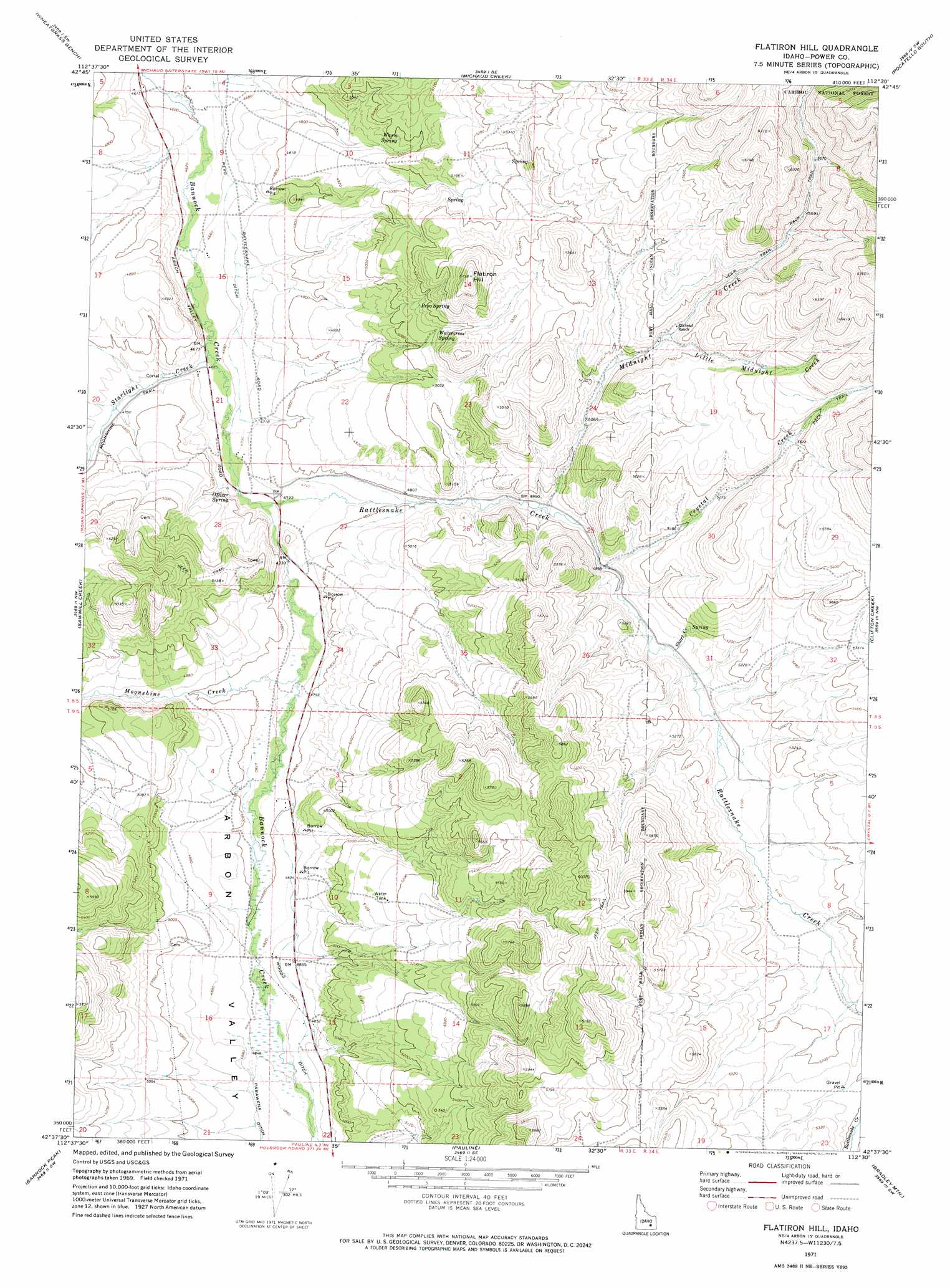
Flatiron Hill Topo Map Idaho
To zoom in, hover over the map of Flatiron Hill
USGS Topo Quad 42112f5 - 1:24,000 scale
| Topo Map Name: | Flatiron Hill |
| USGS Topo Quad ID: | 42112f5 |
| Print Size: | ca. 21 1/4" wide x 27" high |
| Southeast Coordinates: | 42.625° N latitude / 112.5° W longitude |
| Map Center Coordinates: | 42.6875° N latitude / 112.5625° W longitude |
| U.S. State: | ID |
| Filename: | o42112f5.jpg |
| Download Map JPG Image: | Flatiron Hill topo map 1:24,000 scale |
| Map Type: | Topographic |
| Topo Series: | 7.5´ |
| Map Scale: | 1:24,000 |
| Source of Map Images: | United States Geological Survey (USGS) |
| Alternate Map Versions: |
Flatiron Hill ID 1971, updated 1974 Download PDF Buy paper map Flatiron Hill ID 2011 Download PDF Buy paper map Flatiron Hill ID 2013 Download PDF Buy paper map |
| FStopo: | US Forest Service topo Flatiron Hill is available: Download FStopo PDF Download FStopo TIF |
1:24,000 Topo Quads surrounding Flatiron Hill
Aberdeen |
Schiller |
Michaud |
Pocatello North |
Moonlight Mountain |
American Falls |
Wheatgrass Bench |
Michaud Creek |
Pocatello South |
Inkom |
Indian Springs |
Sawmill Creek |
Flatiron Hill |
Clifton Creek |
Scout Mountain |
Rockland East |
Bannock Peak |
Pauline |
Bradley Mountain |
Hawkins |
Roy Ne |
Deep Creek Peak |
Arbon |
Dairy Creek |
Wakley Peak |
> Back to 42112e1 at 1:100,000 scale
> Back to 42112a1 at 1:250,000 scale
> Back to U.S. Topo Maps home
Flatiron Hill topo map: Gazetteer
Flatiron Hill: Canals
Pevo Ditch elevation 1429m 4688′Woods Ditch elevation 1479m 4852′
Flatiron Hill: Springs
Officer Spring elevation 1438m 4717′Pevo Spring elevation 1554m 5098′
Warm Spring elevation 1513m 4963′
Watercress Spring elevation 1562m 5124′
Flatiron Hill: Streams
Clifton Creek elevation 1562m 5124′Crystal Creek elevation 1521m 4990′
Little Midnight Creek elevation 1597m 5239′
Midnight Creek elevation 1498m 4914′
Moonshine Creek elevation 1448m 4750′
Rattlesnake Creek elevation 1435m 4708′
Short Creek elevation 1535m 5036′
Starlight Creek elevation 1424m 4671′
Flatiron Hill: Summits
Flatiron Hill elevation 1746m 5728′Flatiron Hill digital topo map on disk
Buy this Flatiron Hill topo map showing relief, roads, GPS coordinates and other geographical features, as a high-resolution digital map file on DVD: