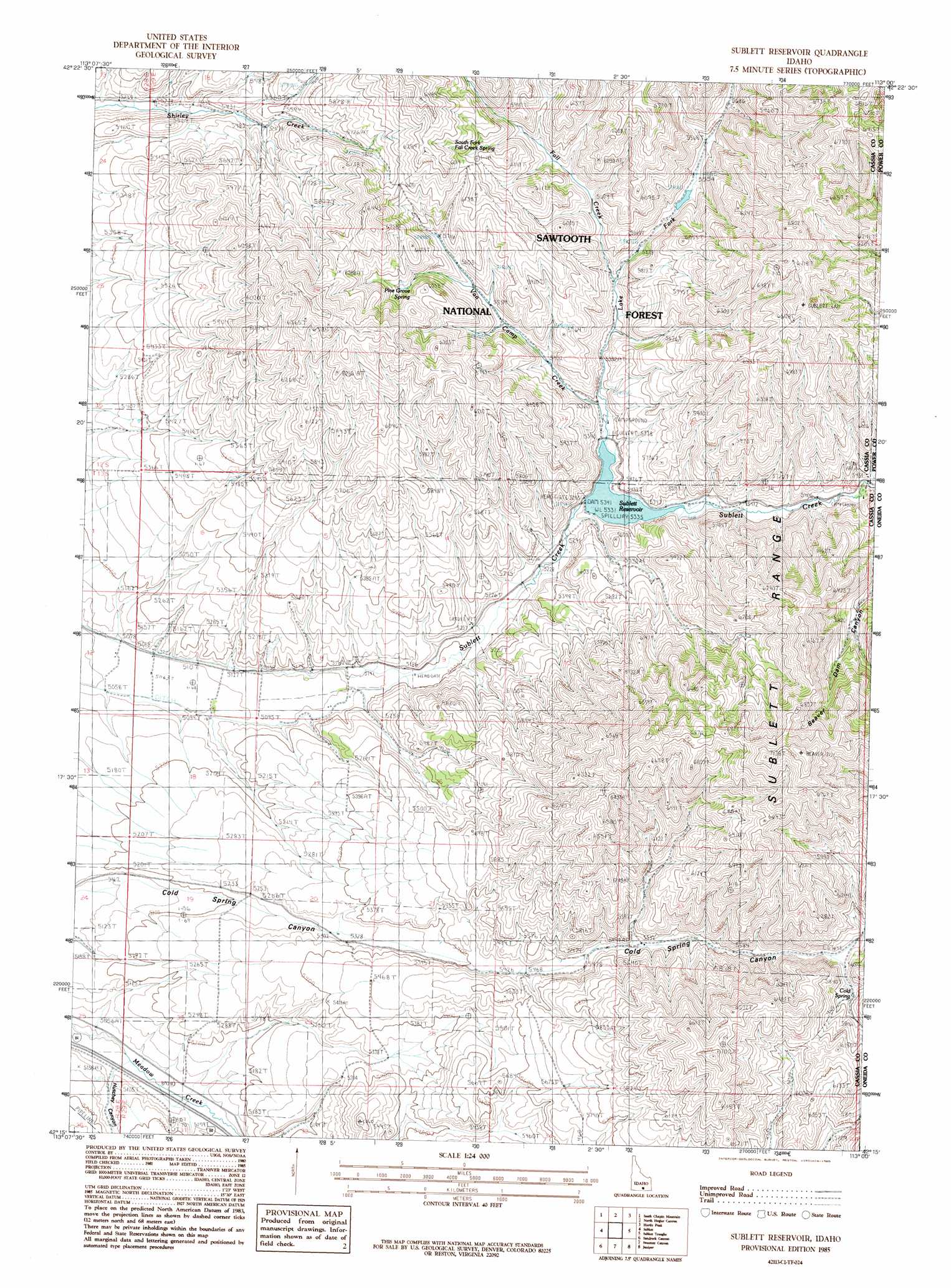
Sublett Reservoir Topo Map Idaho
To zoom in, hover over the map of Sublett Reservoir
USGS Topo Quad 42113c1 - 1:24,000 scale
| Topo Map Name: | Sublett Reservoir |
| USGS Topo Quad ID: | 42113c1 |
| Print Size: | ca. 21 1/4" wide x 27" high |
| Southeast Coordinates: | 42.25° N latitude / 113° W longitude |
| Map Center Coordinates: | 42.3125° N latitude / 113.0625° W longitude |
| U.S. State: | ID |
| Filename: | o42113c1.jpg |
| Download Map JPG Image: | Sublett Reservoir topo map 1:24,000 scale |
| Map Type: | Topographic |
| Topo Series: | 7.5´ |
| Map Scale: | 1:24,000 |
| Source of Map Images: | United States Geological Survey (USGS) |
| Alternate Map Versions: |
Sublett Reservoir ID 1985, updated 1985 Download PDF Buy paper map Sublett Reservoir ID 2001, updated 2006 Download PDF Buy paper map Sublett Reservoir ID 2011 Download PDF Buy paper map Sublett Reservoir ID 2013 Download PDF Buy paper map |
| FStopo: | US Forest Service topo Sublett Reservoir is available: Download FStopo PDF Download FStopo TIF |
1:24,000 Topo Quads surrounding Sublett Reservoir
Lake Walcott Se |
North Chapin Mountain |
Badger Peak |
Rockland West |
Rockland East |
Malta Ne |
South Chapin Mountain |
North Heglar Canyon |
Hartley Peak |
Roy Ne |
Malta |
Sublett |
Sublett Reservoir |
Sublett Troughs |
Roy |
Bridge |
Sandrock Canyon |
Sweetzer Canyon |
Juniper |
Badger Hole Spring |
Naf |
Strevell |
Black Pine Peak |
Black Pine |
The Cove |
> Back to 42113a1 at 1:100,000 scale
> Back to 42112a1 at 1:250,000 scale
> Back to U.S. Topo Maps home
Sublett Reservoir topo map: Gazetteer
Sublett Reservoir: Dams
Sublett Dam elevation 1628m 5341′Sublett Reservoir: Reservoirs
Sublett Reservoir elevation 1628m 5341′Sublett Reservoir: Springs
Cold Spring elevation 1765m 5790′Pine Grove Spring elevation 1793m 5882′
Pine Grove Spring elevation 1789m 5869′
South Fork Fall Creek Spring elevation 1822m 5977′
South Fork Fall Creek Spring elevation 1854m 6082′
Sublett Reservoir: Streams
Fall Creek elevation 1658m 5439′Lake Fork elevation 1629m 5344′
Van Camp Creek elevation 1629m 5344′
Sublett Reservoir: Valleys
Cold Spring Canyon elevation 1565m 5134′Hutchey Canyon elevation 1546m 5072′
Sublett Reservoir digital topo map on disk
Buy this Sublett Reservoir topo map showing relief, roads, GPS coordinates and other geographical features, as a high-resolution digital map file on DVD: