North Heglar Canyon Topo Map Idaho
To zoom in, hover over the map of North Heglar Canyon
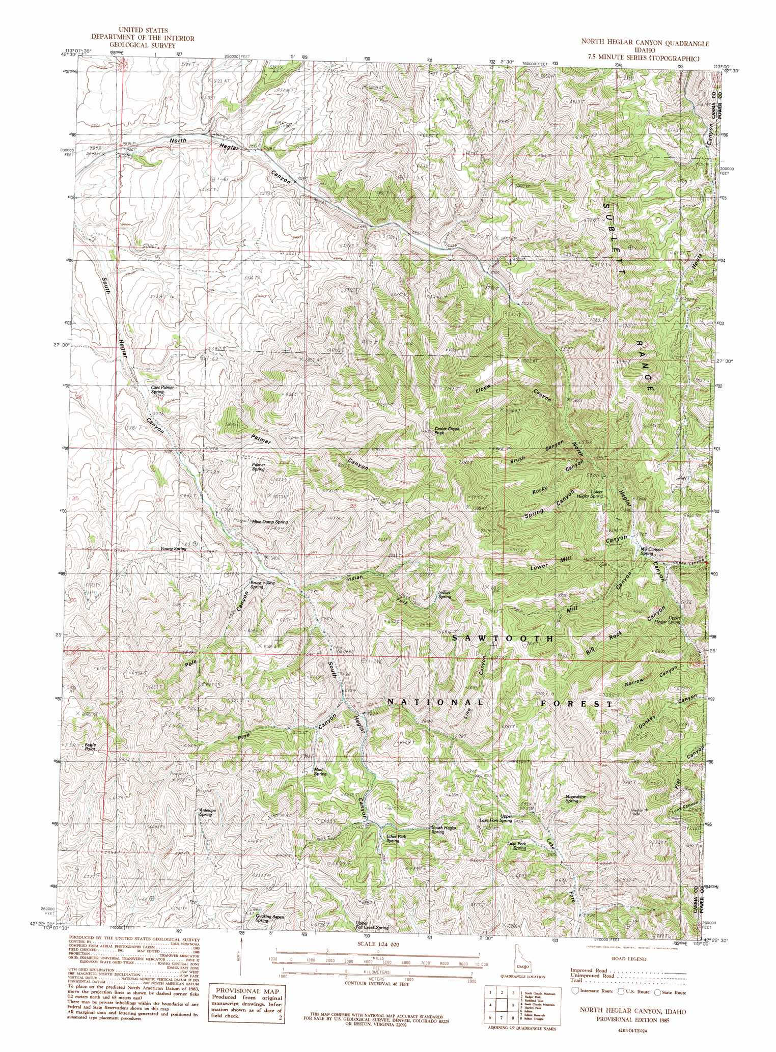
USGS Topo Quad 42113d1 - 1:24,000 scale
| Topo Map Name: | North Heglar Canyon |
| USGS Topo Quad ID: | 42113d1 |
| Print Size: | ca. 21 1/4" wide x 27" high |
| Southeast Coordinates: | 42.375° N latitude / 113° W longitude |
| Map Center Coordinates: | 42.4375° N latitude / 113.0625° W longitude |
| U.S. State: | ID |
| Filename: | o42113d1.jpg |
| Download Map JPG Image: | North Heglar Canyon topo map 1:24,000 scale |
| Map Type: | Topographic |
| Topo Series: | 7.5´ |
| Map Scale: | 1:24,000 |
| Source of Map Images: | United States Geological Survey (USGS) |
| Alternate Map Versions: |
North Heglar Canyon ID 1985, updated 1985 Download PDF Buy paper map North Heglar Canyon ID 2001, updated 2006 Download PDF Buy paper map North Heglar Canyon ID 2011 Download PDF Buy paper map North Heglar Canyon ID 2013 Download PDF Buy paper map |
| FStopo: | US Forest Service topo North Heglar Canyon is available: Download FStopo PDF Download FStopo TIF |
1:24,000 Topo Quads surrounding North Heglar Canyon
Lake Walcott East |
Gifford Spring |
Register Rock |
Neeley |
Indian Springs |
Lake Walcott Se |
North Chapin Mountain |
Badger Peak |
Rockland West |
Rockland East |
Malta Ne |
South Chapin Mountain |
North Heglar Canyon |
Hartley Peak |
Roy Ne |
Malta |
Sublett |
Sublett Reservoir |
Sublett Troughs |
Roy |
Bridge |
Sandrock Canyon |
Sweetzer Canyon |
Juniper |
Badger Hole Spring |
> Back to 42113a1 at 1:100,000 scale
> Back to 42112a1 at 1:250,000 scale
> Back to U.S. Topo Maps home
North Heglar Canyon topo map: Gazetteer
North Heglar Canyon: Springs
Antelope Spring elevation 1820m 5971′Bruce Young Spring elevation 1697m 5567′
Clint Palmer Spring elevation 1538m 5045′
Ether Park Spring elevation 1814m 5951′
Indian Spring elevation 1926m 6318′
Lake Fork Spring elevation 1809m 5935′
Lower Heglar Spring elevation 1804m 5918′
Mill Canyon Spring elevation 1813m 5948′
Mine Dump Spring elevation 1682m 5518′
Moonshine Spring elevation 1880m 6167′
Mud Spring elevation 1765m 5790′
Palmer Spring elevation 1737m 5698′
Quaking Aspen Spring elevation 1808m 5931′
South Heglar Spring elevation 1828m 5997′
Upper Fall Creek Spring elevation 1841m 6040′
Upper Heglar Spring elevation 1918m 6292′
Upper Lake Fork Spring elevation 1841m 6040′
Young Spring elevation 1660m 5446′
North Heglar Canyon: Streams
Indian Fork elevation 1655m 5429′North Heglar Canyon: Summits
Cedar Creek Peak elevation 2261m 7417′Eagle Point elevation 1992m 6535′
North Heglar Canyon: Valleys
Big Rock Canyon elevation 1851m 6072′Brush Canyon elevation 1750m 5741′
Elbow Canyon elevation 1731m 5679′
Line Canyon elevation 1803m 5915′
Lower Mill Canyon elevation 1804m 5918′
Mill Canyon elevation 1810m 5938′
Narrow Canyon elevation 1903m 6243′
Palmer Canyon elevation 1549m 5082′
Pine Canyon elevation 1710m 5610′
Pole Canyon elevation 1653m 5423′
Rocky Canyon elevation 1756m 5761′
Sheep Canyon elevation 1818m 5964′
Spring Canyon elevation 1771m 5810′
North Heglar Canyon digital topo map on disk
Buy this North Heglar Canyon topo map showing relief, roads, GPS coordinates and other geographical features, as a high-resolution digital map file on DVD: