View Topo Map Idaho
To zoom in, hover over the map of View
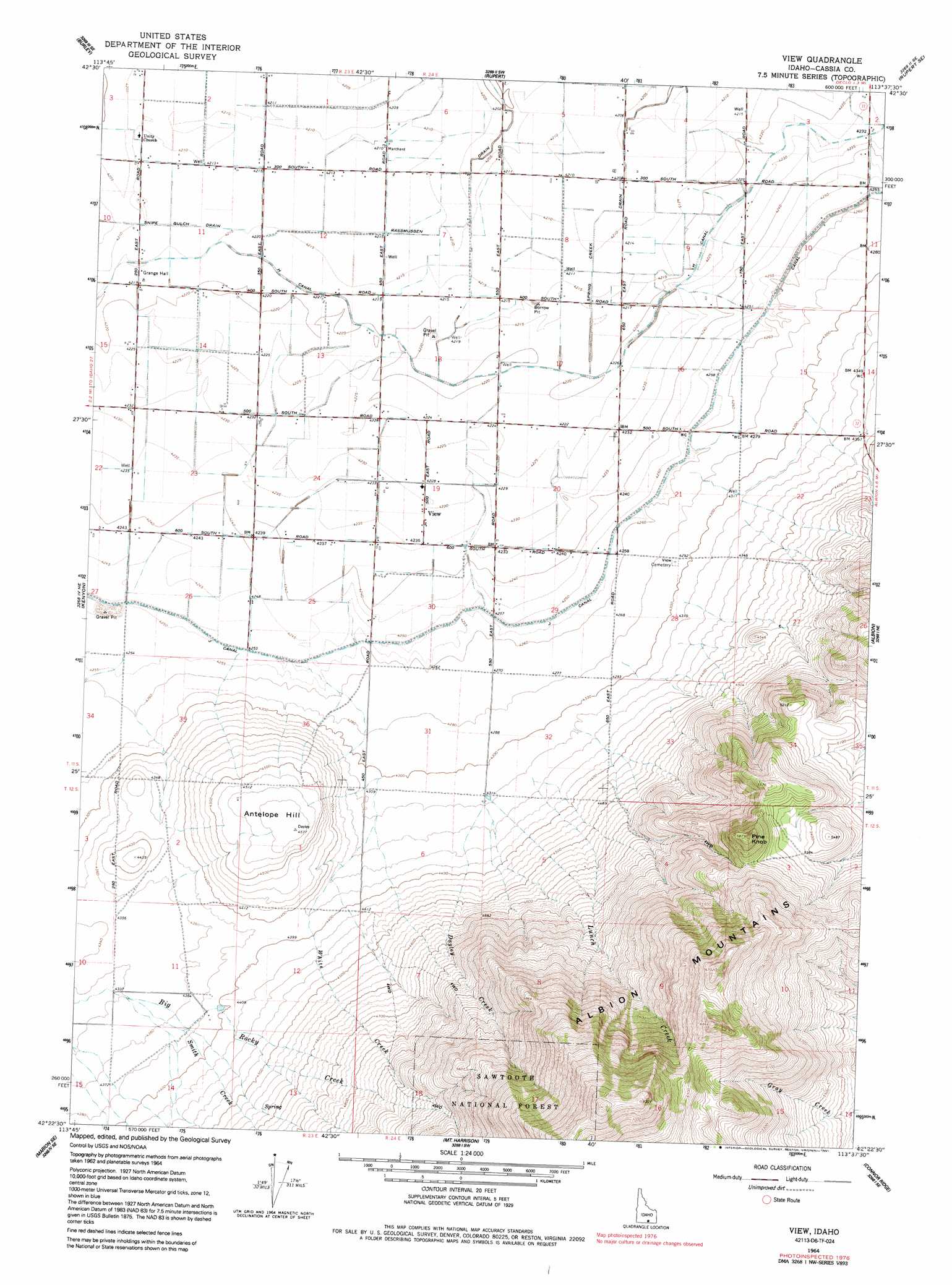
USGS Topo Quad 42113d6 - 1:24,000 scale
| Topo Map Name: | View |
| USGS Topo Quad ID: | 42113d6 |
| Print Size: | ca. 21 1/4" wide x 27" high |
| Southeast Coordinates: | 42.375° N latitude / 113.625° W longitude |
| Map Center Coordinates: | 42.4375° N latitude / 113.6875° W longitude |
| U.S. State: | ID |
| Filename: | o42113d6.jpg |
| Download Map JPG Image: | View topo map 1:24,000 scale |
| Map Type: | Topographic |
| Topo Series: | 7.5´ |
| Map Scale: | 1:24,000 |
| Source of Map Images: | United States Geological Survey (USGS) |
| Alternate Map Versions: |
View ID 1964, updated 1965 Download PDF Buy paper map View ID 1964, updated 1983 Download PDF Buy paper map View ID 1964, updated 1991 Download PDF Buy paper map View ID 2001, updated 2006 Download PDF Buy paper map View ID 2011 Download PDF Buy paper map View ID 2013 Download PDF Buy paper map |
| FStopo: | US Forest Service topo View is available: Download FStopo PDF Download FStopo TIF |
1:24,000 Topo Quads surrounding View
Burley Nw |
Burley Ne |
Rupert Nw |
Acequia |
Lake Walcott West |
Burley Sw |
Burley |
Rupert |
Rupert Se |
Lake Walcott Sw |
Burley Butte |
Kenyon |
View |
Albion |
Idahome |
Marion |
Marion Se |
Mount Harrison |
Connor Ridge |
Nibbs Creek |
Oakley |
Basin |
Cache Peak |
Elba |
Kane Canyon |
> Back to 42113a1 at 1:100,000 scale
> Back to 42112a1 at 1:250,000 scale
> Back to U.S. Topo Maps home
View topo map: Gazetteer
View: Canals
112 A Lateral elevation 1295m 4248′H 10 Lateral elevation 1287m 4222′
H 12 D Lateral elevation 1284m 4212′
H 12 J Lateral elevation 1284m 4212′
H 12 K Lateral elevation 1283m 4209′
H 12 Lateral elevation 1284m 4212′
H 14 H Lateral elevation 1287m 4222′
H 14 Lateral elevation 1283m 4209′
H 15 A Lateral elevation 1286m 4219′
H 15 A Pipeline elevation 1286m 4219′
H 15 B Lateral elevation 1284m 4212′
H 15 C Lateral elevation 1285m 4215′
H 15 D Lateral elevation 1284m 4212′
H 15 Lateral elevation 1285m 4215′
H 16 A Lateral elevation 1286m 4219′
H 16 C Lateral elevation 1286m 4219′
H 16 E Lateral elevation 1284m 4212′
H 16 Lateral elevation 1285m 4215′
H 17 A Lateral elevation 1286m 4219′
H 17 B Lateral elevation 1285m 4215′
H 17 C Lateral elevation 1284m 4212′
H 17 H Lateral elevation 1286m 4219′
H 17 Lateral elevation 1284m 4212′
H 7 A Lateral elevation 1287m 4222′
H 7 Lateral elevation 1288m 4225′
H 8 1/2 Pipeline elevation 1286m 4219′
H 8 A Lateral elevation 1287m 4222′
H 8 Pipeline elevation 1289m 4229′
H 9 Lateral elevation 1285m 4215′
J 10 Lateral elevation 1291m 4235′
J 11 Lateral elevation 1292m 4238′
J 12 A Lateral elevation 1292m 4238′
J 12 B Lateral elevation 1290m 4232′
J 12 Lateral elevation 1292m 4238′
J 12 Pipeline elevation 1294m 4245′
J 13 Lateral elevation 1295m 4248′
J 14 Lateral elevation 1295m 4248′
J 15 Pipeline elevation 1298m 4258′
J 16 Lateral elevation 1297m 4255′
J 17 Pipeline elevation 1295m 4248′
J 19 A Lateral elevation 1296m 4251′
J 19 C Lateral elevation 1290m 4232′
J 19 Lateral elevation 1292m 4238′
J 19.1 Lateral elevation 1296m 4251′
J 19.3 Lateral elevation 1297m 4255′
J 20 Lateral elevation 1294m 4245′
J 21 A Lateral elevation 1292m 4238′
J 21 B Lateral elevation 1290m 4232′
J 21 Lateral elevation 1292m 4238′
J 22 Lateral elevation 1295m 4248′
J 23 A Lateral elevation 1293m 4242′
J 23 C Lateral elevation 1293m 4242′
J 23 D Lateral elevation 1291m 4235′
J 23 D Pipeline elevation 1292m 4238′
J 23 E Lateral elevation 1289m 4229′
J 23 E Pipeline elevation 1290m 4232′
J 23 F Lateral elevation 1291m 4235′
J 23 F Lateral elevation 1291m 4235′
J 23 Lateral elevation 1293m 4242′
J 24 C Lateral elevation 1296m 4251′
J 24 Lateral elevation 1294m 4245′
J 24 Pipeline elevation 1295m 4248′
Lunch Creek Drain elevation 1300m 4265′
Rassmussen Drain elevation 1285m 4215′
Searle Drain elevation 1300m 4265′
Spring Creek Drain elevation 1285m 4215′
View: Populated Places
View elevation 1290m 4232′View: Streams
Dayley Creek elevation 1314m 4311′Lunch Creek elevation 1318m 4324′
Smith Creek elevation 1324m 4343′
White Creek elevation 1310m 4297′
View: Summits
Antelope Hill elevation 1392m 4566′Pine Knob elevation 1685m 5528′
View: Valleys
Spring Canyon elevation 1339m 4393′View digital topo map on disk
Buy this View topo map showing relief, roads, GPS coordinates and other geographical features, as a high-resolution digital map file on DVD: