Severe Spring Topo Map Idaho
To zoom in, hover over the map of Severe Spring
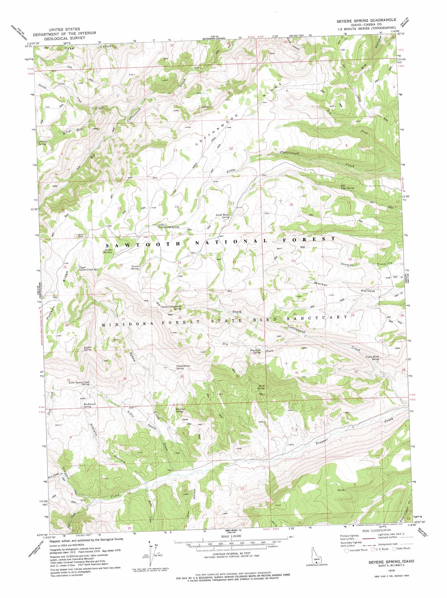
USGS Topo Quad 42114b1 - 1:24,000 scale
| Topo Map Name: | Severe Spring |
| USGS Topo Quad ID: | 42114b1 |
| Print Size: | ca. 21 1/4" wide x 27" high |
| Southeast Coordinates: | 42.125° N latitude / 114° W longitude |
| Map Center Coordinates: | 42.1875° N latitude / 114.0625° W longitude |
| U.S. State: | ID |
| Filename: | o42114b1.jpg |
| Download Map JPG Image: | Severe Spring topo map 1:24,000 scale |
| Map Type: | Topographic |
| Topo Series: | 7.5´ |
| Map Scale: | 1:24,000 |
| Source of Map Images: | United States Geological Survey (USGS) |
| Alternate Map Versions: |
Severe Spring ID 1978, updated 1978 Download PDF Buy paper map Severe Spring ID 2001, updated 2006 Download PDF Buy paper map Severe Spring ID 2011 Download PDF Buy paper map Severe Spring ID 2013 Download PDF Buy paper map |
| FStopo: | US Forest Service topo Severe Spring is available: Download FStopo PDF Download FStopo TIF |
1:24,000 Topo Quads surrounding Severe Spring
Stricker Butte |
Murtaugh |
Milner Butte |
Burley Butte |
Kenyon |
Grand View Peak |
Rams Horn Ridge |
Buckhorn Canyon |
Marion |
Marion Se |
Pike Mountain |
Trapper Peak |
Severe Spring |
Oakley |
Basin |
Timber Butte |
Mahogany Butte |
Ibex Peak |
Blue Hill |
Lyman Pass |
Stratton Spring |
Fivemile Gulch |
Nile Spring |
Pole Creek |
Cotton Thomas Basin |
> Back to 42114a1 at 1:100,000 scale
> Back to 42114a1 at 1:250,000 scale
> Back to U.S. Topo Maps home
Severe Spring topo map: Gazetteer
Severe Spring: Flats
Durfee Meadow elevation 2198m 7211′Severe Spring: Springs
Aspen Spring elevation 2166m 7106′Big Pipe Spring elevation 1824m 5984′
Birch Spring elevation 1745m 5725′
Buckbrush Spring elevation 1891m 6204′
Cedar Birch Spring elevation 1714m 5623′
Chokecherry Spring elevation 1844m 6049′
Dry Fork Spring elevation 1879m 6164′
Dummer Spring elevation 1697m 5567′
Layton Spring elevation 2116m 6942′
Little Cottonwood Spring elevation 2135m 7004′
Little Squaw Creek Spring elevation 1899m 6230′
North Water Spring elevation 2060m 6758′
Severe Spring elevation 2198m 7211′
South Cottonwood Spring elevation 2092m 6863′
Upper Squaw Creek Spring elevation 2175m 7135′
Severe Spring: Streams
Billys Hole Creek elevation 1768m 5800′Buck Corral Creek elevation 1669m 5475′
Dry Fork elevation 1768m 5800′
Dry Fork elevation 1658m 5439′
Dry Fork Little Cottonwood Creek elevation 1662m 5452′
Fall Creek elevation 1632m 5354′
Little Squaw Creek elevation 1605m 5265′
Rodeo Creek elevation 1620m 5314′
Squaw Creek elevation 1598m 5242′
Terrells Corral Creek elevation 1948m 6391′
Severe Spring: Valleys
Ibex Hollow elevation 1608m 5275′Violets Hollow elevation 1623m 5324′
Severe Spring digital topo map on disk
Buy this Severe Spring topo map showing relief, roads, GPS coordinates and other geographical features, as a high-resolution digital map file on DVD: