Pike Mountain Topo Map Idaho
To zoom in, hover over the map of Pike Mountain
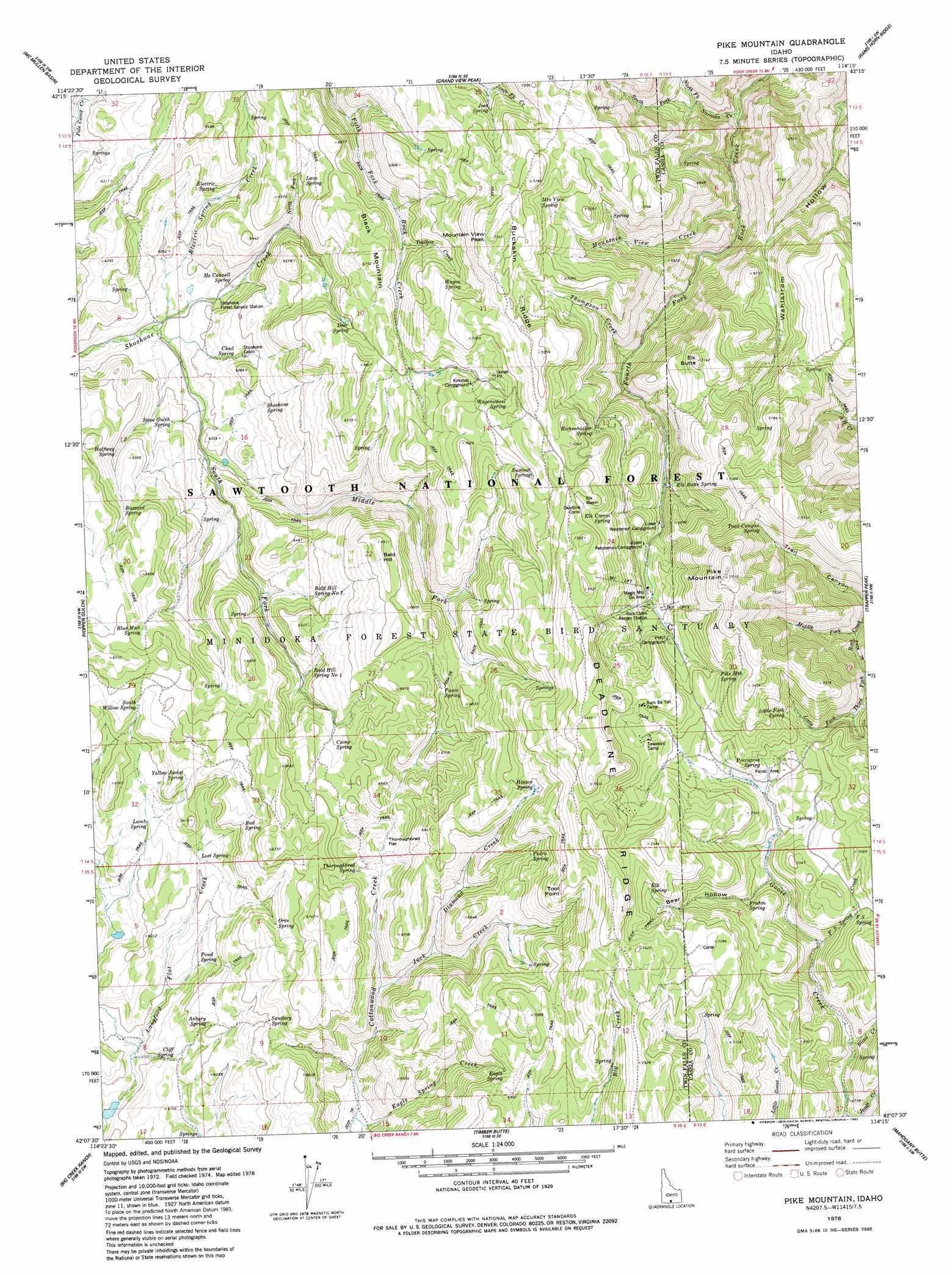
USGS Topo Quad 42114b3 - 1:24,000 scale
| Topo Map Name: | Pike Mountain |
| USGS Topo Quad ID: | 42114b3 |
| Print Size: | ca. 21 1/4" wide x 27" high |
| Southeast Coordinates: | 42.125° N latitude / 114.25° W longitude |
| Map Center Coordinates: | 42.1875° N latitude / 114.3125° W longitude |
| U.S. State: | ID |
| Filename: | o42114b3.jpg |
| Download Map JPG Image: | Pike Mountain topo map 1:24,000 scale |
| Map Type: | Topographic |
| Topo Series: | 7.5´ |
| Map Scale: | 1:24,000 |
| Source of Map Images: | United States Geological Survey (USGS) |
| Alternate Map Versions: |
Pike Mountain ID 1978, updated 1978 Download PDF Buy paper map Pike Mountain ID 1978, updated 1982 Download PDF Buy paper map Pike Mountain ID 2001, updated 2006 Download PDF Buy paper map Pike Mountain ID 2011 Download PDF Buy paper map Pike Mountain ID 2013 Download PDF Buy paper map |
| FStopo: | US Forest Service topo Pike Mountain is available: Download FStopo PDF Download FStopo TIF |
1:24,000 Topo Quads surrounding Pike Mountain
Berger |
Hub Butte |
Stricker Butte |
Murtaugh |
Milner Butte |
Hollister |
Mcmullen Basin |
Grand View Peak |
Rams Horn Ridge |
Buckhorn Canyon |
Rogerson |
Hopper Gulch |
Pike Mountain |
Trapper Peak |
Severe Spring |
Magic Hot Springs |
Big Creek Ranch |
Timber Butte |
Mahogany Butte |
Ibex Peak |
East Of Jackpot |
Gollaher Mountain |
Stratton Spring |
Fivemile Gulch |
Nile Spring |
> Back to 42114a1 at 1:100,000 scale
> Back to 42114a1 at 1:250,000 scale
> Back to U.S. Topo Maps home
Pike Mountain topo map: Gazetteer
Pike Mountain: Basins
Elk Basin elevation 2209m 7247′Pike Mountain: Cliffs
Tool Point elevation 2197m 7208′Pike Mountain: Falls
Ross Falls elevation 1953m 6407′Pike Mountain: Flats
Thoroughbred Flat elevation 1961m 6433′Pike Mountain: Ridges
Buckskin Ridge elevation 2184m 7165′Pike Mountain: Springs
Ashbury Spring elevation 1887m 6190′Bald Hill Spring Number 1 elevation 1918m 6292′
Bald Hill Spring Number 2 elevation 1922m 6305′
Blue Mud Spring elevation 1999m 6558′
Bud Spring elevation 1962m 6437′
Buzzard Spring elevation 1938m 6358′
Camp Spring elevation 1980m 6496′
Chad Spring elevation 1865m 6118′
Cliff Spring elevation 1844m 6049′
Deer Spring elevation 2001m 6564′
Eagle Spring elevation 2079m 6820′
Electric Spring elevation 1902m 6240′
Elk Butte Spring elevation 2032m 6666′
Elk Corral Spring elevation 2134m 7001′
Elk Spring elevation 2185m 7168′
F S Spring elevation 2094m 6870′
Fawn Spring elevation 2010m 6594′
Frahm Spring elevation 2074m 6804′
Halfway Spring elevation 1877m 6158′
Hinton Spring elevation 2124m 6968′
Joes Spring elevation 2070m 6791′
Lamb Spring elevation 1917m 6289′
Lava Spring elevation 1954m 6410′
Little Fork Spring elevation 2135m 7004′
Lost Spring elevation 1901m 6236′
McConnell Spring elevation 1832m 6010′
Mountain View Spring elevation 2155m 7070′
Orin Spring elevation 1962m 6437′
Pedro Spring elevation 2062m 6765′
Pike Mountain Spring elevation 2149m 7050′
Pond Spring elevation 1858m 6095′
Porcupine Spring elevation 2129m 6984′
Rickenbacker Spring elevation 2103m 6899′
Sanitary Spring elevation 1953m 6407′
Shoshone Spring elevation 1878m 6161′
South Willow Spring elevation 1986m 6515′
Stove Gulch Spring elevation 1845m 6053′
Summit Spring elevation 2133m 6998′
Thoroughbred Spring elevation 1964m 6443′
Trail Canyon Spring elevation 2111m 6925′
Wagon Spring elevation 2082m 6830′
Wagonwheel Spring elevation 2108m 6916′
Yellow Jacket Spring elevation 1967m 6453′
Pike Mountain: Streams
Blind Creek elevation 1988m 6522′Diamond Creek elevation 1946m 6384′
Eagle Spring Creek elevation 1866m 6122′
Electric Spring Creek elevation 1805m 5921′
F S Spring Creek elevation 2012m 6601′
Jack Creek elevation 1920m 6299′
Middle Fork Shoshone Creek elevation 1819m 5967′
Middle Fork Third Fork Rock Creek elevation 1947m 6387′
Mountain View Creek elevation 1778m 5833′
Narrows Creek elevation 1690m 5544′
North Fork Narrows Creek elevation 1768m 5800′
North Fork Shoshone Creek elevation 1909m 6263′
South Fork Narrows Creek elevation 1768m 5800′
South Fork Shoshone Creek elevation 1803m 5915′
Toolbox Creek elevation 1973m 6473′
Pike Mountain: Summits
Bald Hill elevation 2100m 6889′Black Mountain elevation 2066m 6778′
Elk Butte elevation 2176m 7139′
Mountain View Peak elevation 2244m 7362′
Pike Mountain elevation 2346m 7696′
Pike Mountain: Valleys
Bear Hollow elevation 2059m 6755′Trail Canyon elevation 1937m 6354′
Pike Mountain digital topo map on disk
Buy this Pike Mountain topo map showing relief, roads, GPS coordinates and other geographical features, as a high-resolution digital map file on DVD: