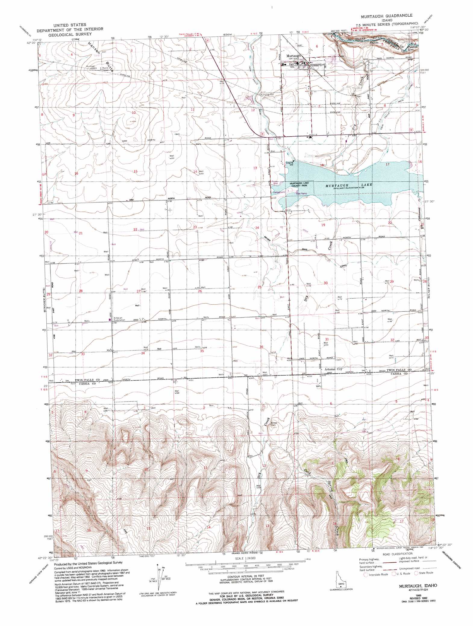
Murtaugh Topo Map Idaho
To zoom in, hover over the map of Murtaugh
USGS Topo Quad 42114d2 - 1:24,000 scale
| Topo Map Name: | Murtaugh |
| USGS Topo Quad ID: | 42114d2 |
| Print Size: | ca. 21 1/4" wide x 27" high |
| Southeast Coordinates: | 42.375° N latitude / 114.125° W longitude |
| Map Center Coordinates: | 42.4375° N latitude / 114.1875° W longitude |
| U.S. State: | ID |
| Filename: | o42114d2.jpg |
| Download Map JPG Image: | Murtaugh topo map 1:24,000 scale |
| Map Type: | Topographic |
| Topo Series: | 7.5´ |
| Map Scale: | 1:24,000 |
| Source of Map Images: | United States Geological Survey (USGS) |
| Alternate Map Versions: |
Murtaugh ID 1965, updated 1966 Download PDF Buy paper map Murtaugh ID 1965, updated 1992 Download PDF Buy paper map Murtaugh ID 2010 Download PDF Buy paper map Murtaugh ID 2013 Download PDF Buy paper map |
1:24,000 Topo Quads surrounding Murtaugh
Falls City |
Twin Falls Ne |
Hunt |
Eden Ne |
Burley Nw |
Twin Falls |
Kimberly |
Eden |
Milner |
Burley Sw |
Hub Butte |
Stricker Butte |
Murtaugh |
Milner Butte |
Burley Butte |
Mcmullen Basin |
Grand View Peak |
Rams Horn Ridge |
Buckhorn Canyon |
Marion |
Hopper Gulch |
Pike Mountain |
Trapper Peak |
Severe Spring |
Oakley |
> Back to 42114a1 at 1:100,000 scale
> Back to 42114a1 at 1:250,000 scale
> Back to U.S. Topo Maps home
Murtaugh topo map: Gazetteer
Murtaugh: Dams
Murtaugh Lake Dam elevation 1259m 4130′Murtaugh: Parks
Murtaugh Lake County Park elevation 1260m 4133′Murtaugh: Populated Places
Artesian City elevation 1291m 4235′Murtaugh elevation 1245m 4084′
Murtaugh: Rapids
Caldron Linn elevation 1190m 3904′Murtaugh: Reservoirs
Murtaugh Lake elevation 1259m 4130′Murtaugh: Streams
Big Cottonwood Creek elevation 1259m 4130′Cold Spring Creek elevation 1310m 4297′
Dry Creek elevation 1170m 3838′
Murtaugh digital topo map on disk
Buy this Murtaugh topo map showing relief, roads, GPS coordinates and other geographical features, as a high-resolution digital map file on DVD: