Riddle Topo Map Idaho
To zoom in, hover over the map of Riddle
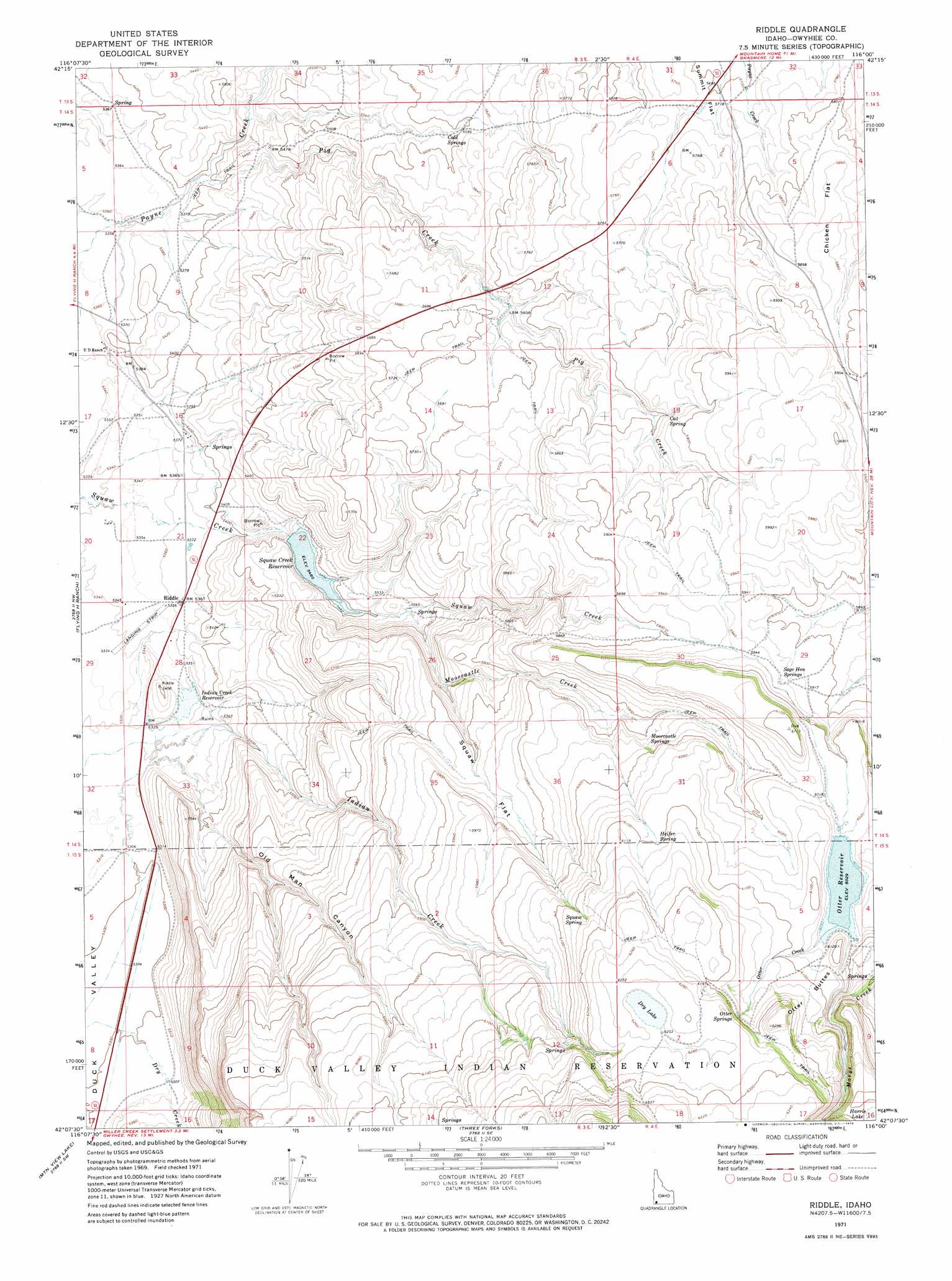
USGS Topo Quad 42116b1 - 1:24,000 scale
| Topo Map Name: | Riddle |
| USGS Topo Quad ID: | 42116b1 |
| Print Size: | ca. 21 1/4" wide x 27" high |
| Southeast Coordinates: | 42.125° N latitude / 116° W longitude |
| Map Center Coordinates: | 42.1875° N latitude / 116.0625° W longitude |
| U.S. State: | ID |
| Filename: | o42116b1.jpg |
| Download Map JPG Image: | Riddle topo map 1:24,000 scale |
| Map Type: | Topographic |
| Topo Series: | 7.5´ |
| Map Scale: | 1:24,000 |
| Source of Map Images: | United States Geological Survey (USGS) |
| Alternate Map Versions: |
Riddle ID 1971, updated 1974 Download PDF Buy paper map Riddle ID 2010 Download PDF Buy paper map Riddle ID 2013 Download PDF Buy paper map |
1:24,000 Topo Quads surrounding Riddle
Lost Valley |
Turner Table |
Wickahoney Point |
Grasmere |
Blackstone Reservoir |
Shoofly Springs |
Nichol Flat |
Little Blue Table |
Grasmere Reservoir |
Buster Butte |
Ross Lake |
Flying H Ranch |
Riddle |
Buckhorn |
Antelope Creek |
Juniper Basin Se |
Mountain View Lake |
Three Forks |
Indian Hay Meadows |
Black Leg Creek |
Groundhog Reservoir |
The Point |
Owyhee |
Winter Ridge |
Hicks Mountain |
> Back to 42116a1 at 1:100,000 scale
> Back to 42116a1 at 1:250,000 scale
> Back to U.S. Topo Maps home
Riddle topo map: Gazetteer
Riddle: Airports
Riddle Airport elevation 1630m 5347′Riddle: Dams
Alder Dam elevation 1839m 6033′Squaw Creek Dam elevation 1668m 5472′
Riddle: Flats
Chicken Flat elevation 1789m 5869′Squaw Flat elevation 1781m 5843′
Summit Flat elevation 1738m 5702′
Riddle: Lakes
Dry Lake elevation 1908m 6259′Riddle: Populated Places
Riddle elevation 1636m 5367′Riddle: Reservoirs
Indian Creek Reservoir elevation 1628m 5341′Otter Reservoir elevation 1839m 6033′
Squaw Creek Reservoir elevation 1668m 5472′
Riddle: Springs
Cat Spring elevation 1774m 5820′Cold Springs elevation 1704m 5590′
Heifer Spring elevation 1861m 6105′
Moorcastle Springs elevation 1802m 5912′
Otter Springs elevation 1889m 6197′
Sage Hen Springs elevation 1809m 5935′
Squaw Spring elevation 1873m 6145′
Riddle: Streams
Dry Creek elevation 1616m 5301′Indian Creek elevation 1627m 5337′
Moorcastle Creek elevation 1689m 5541′
Otter Creek elevation 1839m 6033′
Pig Creek elevation 1643m 5390′
Riddle: Summits
Otter Buttes elevation 1914m 6279′Riddle: Valleys
Old Man Canyon elevation 1622m 5321′Riddle digital topo map on disk
Buy this Riddle topo map showing relief, roads, GPS coordinates and other geographical features, as a high-resolution digital map file on DVD: