Robbers Roost Topo Map Oregon
To zoom in, hover over the map of Robbers Roost
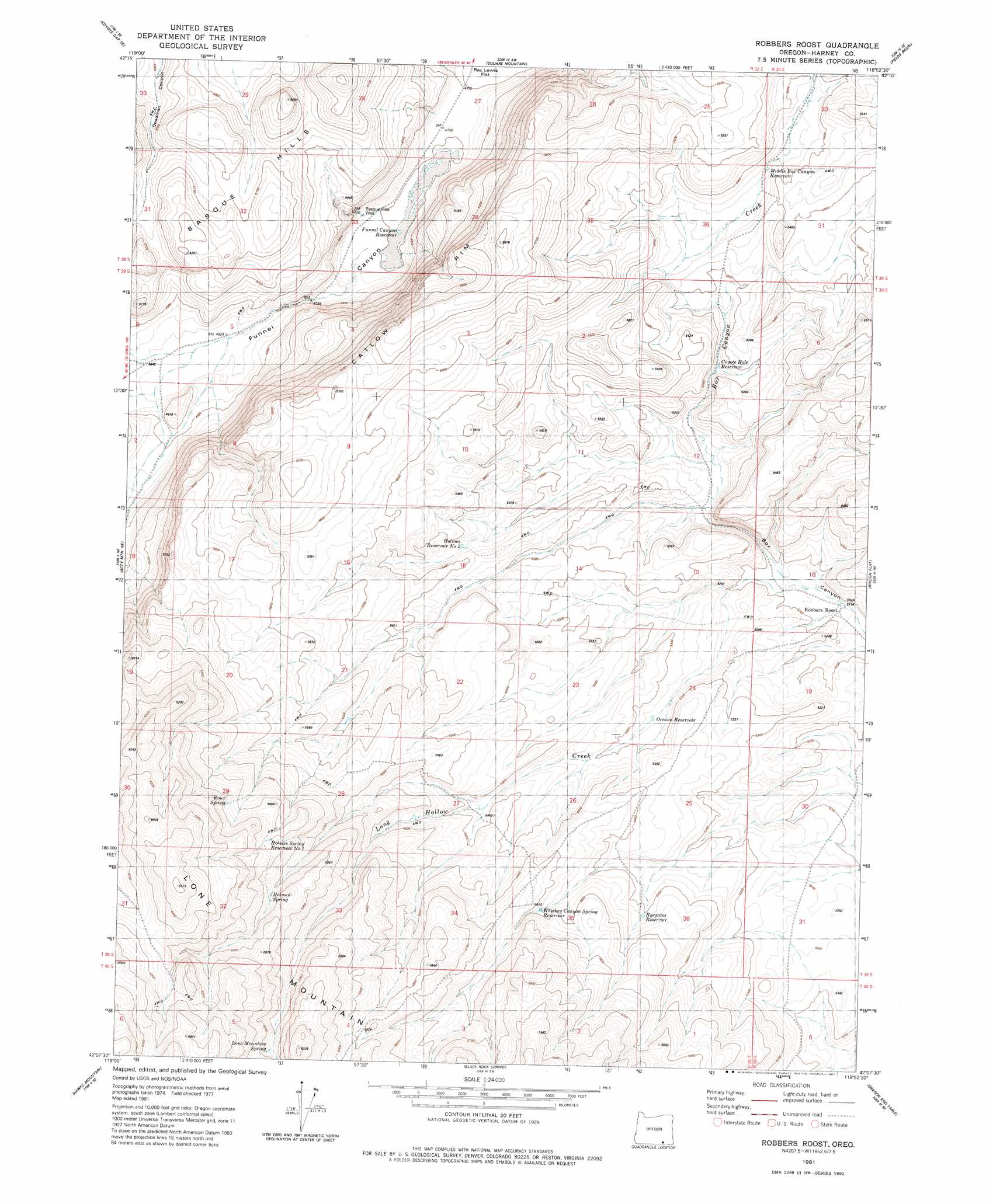
USGS Topo Quad 42118b8 - 1:24,000 scale
| Topo Map Name: | Robbers Roost |
| USGS Topo Quad ID: | 42118b8 |
| Print Size: | ca. 21 1/4" wide x 27" high |
| Southeast Coordinates: | 42.125° N latitude / 118.875° W longitude |
| Map Center Coordinates: | 42.1875° N latitude / 118.9375° W longitude |
| U.S. State: | OR |
| Filename: | o42118b8.jpg |
| Download Map JPG Image: | Robbers Roost topo map 1:24,000 scale |
| Map Type: | Topographic |
| Topo Series: | 7.5´ |
| Map Scale: | 1:24,000 |
| Source of Map Images: | United States Geological Survey (USGS) |
| Alternate Map Versions: |
Robbers Roost OR 1981, updated 1981 Download PDF Buy paper map Robbers Roost OR 2011 Download PDF Buy paper map Robbers Roost OR 2014 Download PDF Buy paper map |
1:24,000 Topo Quads surrounding Robbers Roost
Fish Fin Rim |
Coyote Gap |
Garrison Lake |
Skull Creek Butte |
V Lake |
Surveyors Lake |
Coyote Gap Se |
Square Mountain |
Fields Basin |
Fields |
Acty Mountain Nw |
Acty Mountain Ne |
Robbers Roost |
Rincon Flat |
Ladycomb Peak |
Acty Mountain |
Hawks Mountain |
Black Rock Springs |
Oregon End Table |
Van Horn Basin |
Big Spring Butte |
Thousand Creek Spring |
Thousand Creek Gorge |
Bog Hot Springs |
Denio |
> Back to 42118a1 at 1:100,000 scale
> Back to 42118a1 at 1:250,000 scale
> Back to U.S. Topo Maps home
Robbers Roost topo map: Gazetteer
Robbers Roost: Basins
Robbers Roost elevation 1579m 5180′Robbers Roost: Reservoirs
Antelope Guzzler elevation 1563m 5127′Coyote Hole Reservoir elevation 1603m 5259′
Funnel Canyon Reservoir elevation 1431m 4694′
Holmes Reservoir Number Two elevation 1632m 5354′
Holmes Spring Reservoir Number One elevation 1808m 5931′
Middle Box Canyon Reservoir elevation 1628m 5341′
Oreana Reservoir elevation 1609m 5278′
Roux Spring Reservoir elevation 1830m 6003′
Ryegrass Reservoir elevation 1651m 5416′
Small Guzzler elevation 1472m 4829′
Whiskey Canyon Spring Reservoir elevation 1672m 5485′
Robbers Roost: Springs
Holmes Spring elevation 1783m 5849′Holmes Spring Number One elevation 1808m 5931′
Lone Mountain Spring elevation 1825m 5987′
Roux Spring elevation 1830m 6003′
Robbers Roost: Streams
Box Canyon Creek elevation 1580m 5183′Robbers Roost: Valleys
Funnel Canyon elevation 1447m 4747′Robbers Roost: Wells
Basque Hills Well elevation 1440m 4724′Robbers Roost digital topo map on disk
Buy this Robbers Roost topo map showing relief, roads, GPS coordinates and other geographical features, as a high-resolution digital map file on DVD: