Tombstone Canyon Topo Map Oregon
To zoom in, hover over the map of Tombstone Canyon
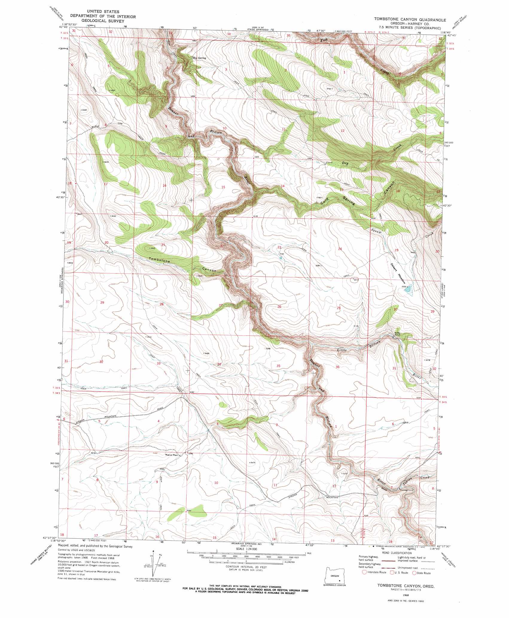
USGS Topo Quad 42118f7 - 1:24,000 scale
| Topo Map Name: | Tombstone Canyon |
| USGS Topo Quad ID: | 42118f7 |
| Print Size: | ca. 21 1/4" wide x 27" high |
| Southeast Coordinates: | 42.625° N latitude / 118.75° W longitude |
| Map Center Coordinates: | 42.6875° N latitude / 118.8125° W longitude |
| U.S. State: | OR |
| Filename: | o42118f7.jpg |
| Download Map JPG Image: | Tombstone Canyon topo map 1:24,000 scale |
| Map Type: | Topographic |
| Topo Series: | 7.5´ |
| Map Scale: | 1:24,000 |
| Source of Map Images: | United States Geological Survey (USGS) |
| Alternate Map Versions: |
Tombstone Canyon OR 1968, updated 1972 Download PDF Buy paper map Tombstone Canyon OR 2011 Download PDF Buy paper map Tombstone Canyon OR 2014 Download PDF Buy paper map |
1:24,000 Topo Quads surrounding Tombstone Canyon
Keg Sprs Valley East |
Irish Lake |
Krumbo Reservoir |
Krumbo Ridge |
Poison Springs |
Walls Lake |
Frenchglen |
Page Springs |
Mccoy Ridge |
Big Pasture Creek |
Butler Hill |
Roaring Springs |
Tombstone Canyon |
Fish Lake |
Wildhorse Lake |
Blitzen |
Home Creek Butte |
Roaring Springs Se |
Ankle Creek |
Alvord Hot Springs |
Coyote Gap |
Garrison Lake |
Skull Creek Butte |
V Lake |
Andrews |
> Back to 42118e1 at 1:100,000 scale
> Back to 42118a1 at 1:250,000 scale
> Back to U.S. Topo Maps home
Tombstone Canyon topo map: Gazetteer
Tombstone Canyon: Crossings
Bradeen Crossing elevation 1550m 5085′Tombstone Canyon: Dams
Fred Riddles Dam elevation 1630m 5347′Tombstone Canyon: Flats
Desert Meadow elevation 1625m 5331′Tombstone Canyon: Reservoirs
Fred Riddles Reservoir elevation 1630m 5347′Riddle Reservoir elevation 1631m 5351′
Tombstone Reservoir elevation 1646m 5400′
Tombstone Canyon: Springs
Big Spring elevation 1458m 4783′Burnt Car Spring elevation 1496m 4908′
Tombstone Spring elevation 1606m 5269′
Tombstone Canyon: Streams
Dry Creek elevation 1394m 4573′Indian Creek elevation 1547m 5075′
Indian Spring Creek elevation 1431m 4694′
Little Blitzen River elevation 1482m 4862′
Squaw Creek elevation 1574m 5164′
Tombstone Canyon: Valleys
Cold Spring Canyon elevation 1406m 4612′Tombstone Canyon elevation 1482m 4862′
Tombstone Canyon digital topo map on disk
Buy this Tombstone Canyon topo map showing relief, roads, GPS coordinates and other geographical features, as a high-resolution digital map file on DVD: