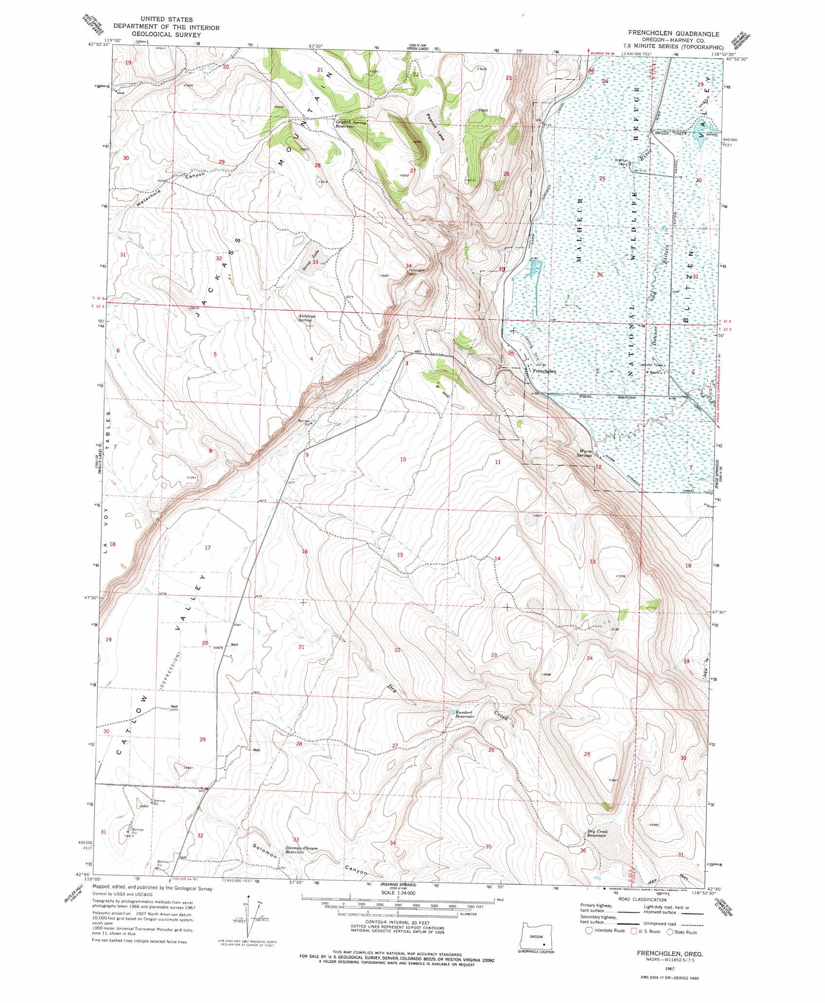
Frenchglen Topo Map Oregon
To zoom in, hover over the map of Frenchglen
USGS Topo Quad 42118g8 - 1:24,000 scale
| Topo Map Name: | Frenchglen |
| USGS Topo Quad ID: | 42118g8 |
| Print Size: | ca. 21 1/4" wide x 27" high |
| Southeast Coordinates: | 42.75° N latitude / 118.875° W longitude |
| Map Center Coordinates: | 42.8125° N latitude / 118.9375° W longitude |
| U.S. State: | OR |
| Filename: | o42118g8.jpg |
| Download Map JPG Image: | Frenchglen topo map 1:24,000 scale |
| Map Type: | Topographic |
| Topo Series: | 7.5´ |
| Map Scale: | 1:24,000 |
| Source of Map Images: | United States Geological Survey (USGS) |
| Alternate Map Versions: |
Frenchglen OR 1967, updated 1972 Download PDF Buy paper map Frenchglen OR 1967, updated 1978 Download PDF Buy paper map Frenchglen OR 2011 Download PDF Buy paper map Frenchglen OR 2014 Download PDF Buy paper map |
1:24,000 Topo Quads surrounding Frenchglen
Weed Lake Butte |
Twin Buttes |
Jackass Butte |
Diamond Swamp |
Diamond |
Keg Sprs Valley West |
Keg Sprs Valley East |
Irish Lake |
Krumbo Reservoir |
Krumbo Ridge |
Duhaime Flat East |
Walls Lake |
Frenchglen |
Page Springs |
Mccoy Ridge |
Blitzen Nw |
Butler Hill |
Roaring Springs |
Tombstone Canyon |
Fish Lake |
Blitzen Sw |
Blitzen |
Home Creek Butte |
Roaring Springs Se |
Ankle Creek |
> Back to 42118e1 at 1:100,000 scale
> Back to 42118a1 at 1:250,000 scale
> Back to U.S. Topo Maps home
Frenchglen topo map: Gazetteer
Frenchglen: Canals
Warm Springs Canal elevation 1275m 4183′Frenchglen: Flats
Peanut Lake elevation 1558m 5111′Savoy Lake elevation 1630m 5347′
Frenchglen: Parks
Frenchglen Hotel State Park elevation 1281m 4202′Frenchglen: Plains
La Voy Tables elevation 1551m 5088′Frenchglen: Populated Places
Frenchglen elevation 1281m 4202′Frenchglen: Post Offices
Frenchglen Post Office elevation 1281m 4202′Frenchglen: Reservoirs
Broadgate Waterhole elevation 1403m 4603′Colt Waterhole elevation 1577m 5173′
Dry Creek Reservoir elevation 1604m 5262′
Griffith Spring Reservoir elevation 1590m 5216′
Kundert Reservoir elevation 1522m 4993′
Mustang Waterhole elevation 1577m 5173′
Solomon Canyon Reservoir elevation 1446m 4744′
Frenchglen: Ridges
P Hill elevation 1492m 4895′Frenchglen: Springs
Antelope Spring elevation 1610m 5282′Warm Springs elevation 1284m 4212′
Frenchglen: Streams
Dry Creek elevation 1396m 4580′Warm Springs Creek elevation 1281m 4202′
Frenchglen: Valleys
Solomon Canyon elevation 1404m 4606′Frenchglen digital topo map on disk
Buy this Frenchglen topo map showing relief, roads, GPS coordinates and other geographical features, as a high-resolution digital map file on DVD: