Antelope Butte Topo Map Oregon
To zoom in, hover over the map of Antelope Butte
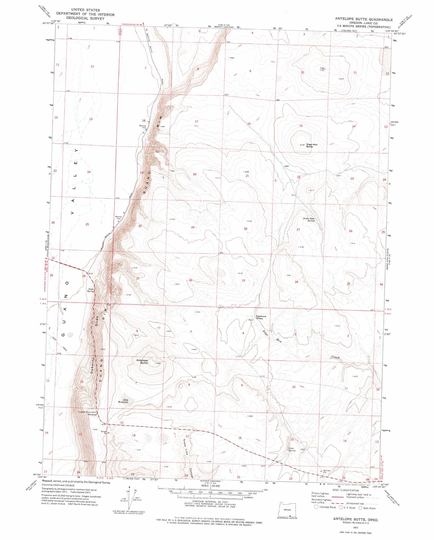
USGS Topo Quad 42119a4 - 1:24,000 scale
| Topo Map Name: | Antelope Butte |
| USGS Topo Quad ID: | 42119a4 |
| Print Size: | ca. 21 1/4" wide x 27" high |
| Southeast Coordinates: | 42° N latitude / 119.375° W longitude |
| Map Center Coordinates: | 42.0625° N latitude / 119.4375° W longitude |
| U.S. State: | OR |
| Filename: | o42119a4.jpg |
| Download Map JPG Image: | Antelope Butte topo map 1:24,000 scale |
| Map Type: | Topographic |
| Topo Series: | 7.5´ |
| Map Scale: | 1:24,000 |
| Source of Map Images: | United States Geological Survey (USGS) |
| Alternate Map Versions: |
Antelope Butte OR 1971, updated 1975 Download PDF Buy paper map Antelope Butte OR 2011 Download PDF Buy paper map Antelope Butte OR 2014 Download PDF Buy paper map |
1:24,000 Topo Quads surrounding Antelope Butte
Jacobs Reservoir |
Alger Lake |
Lone Grave Butte |
Mahogany Butte |
Surveyors Lake |
Mud Lake Reservoir |
Guano Lake |
Rocky Canyon |
Chimney Rock |
Acty Mountain Nw |
Blizzard Gap |
Piute Reservoir |
Antelope Butte |
Sage Hen Flats |
Acty Mountain |
Coleman Canyon |
Rye Creek |
Catnip Canyon |
Sage Hen Hills |
Big Spring Butte |
Calcutta Lake |
Bald Mountain |
Swan Lake |
Catnip Mountain Se |
Gooch Lake |
> Back to 42119a1 at 1:100,000 scale
> Back to 42118a1 at 1:250,000 scale
> Back to U.S. Topo Maps home
Antelope Butte topo map: Gazetteer
Antelope Butte: Cliffs
Guano Rim elevation 1827m 5994′Antelope Butte: Lakes
Slide Waterhole elevation 1874m 6148′Antelope Butte: Parks
Langslet Monument Rest Area elevation 1893m 6210′Antelope Butte: Slopes
Doherty Slide elevation 1735m 5692′Antelope Butte: Springs
Lane Spring elevation 1860m 6102′Sagebrush Spring elevation 1859m 6099′
Slide Spring elevation 1590m 5216′
Snake Eyes Spring elevation 1854m 6082′
Antelope Butte: Summits
Antelope Butte elevation 1961m 6433′Sage Butte elevation 1904m 6246′
Sage Hen Butte elevation 1879m 6164′
Antelope Butte: Valleys
State Line Canyon elevation 1611m 5285′Antelope Butte digital topo map on disk
Buy this Antelope Butte topo map showing relief, roads, GPS coordinates and other geographical features, as a high-resolution digital map file on DVD: