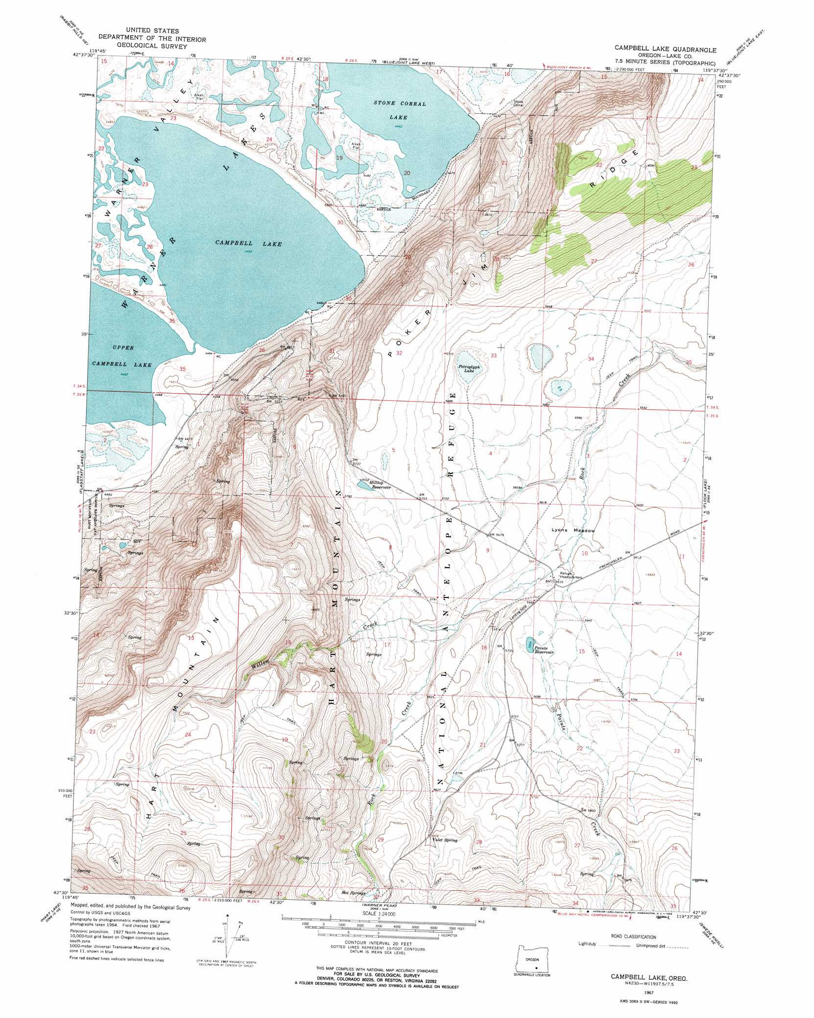
Campbell Lake Topo Map Oregon
To zoom in, hover over the map of Campbell Lake
USGS Topo Quad 42119e6 - 1:24,000 scale
| Topo Map Name: | Campbell Lake |
| USGS Topo Quad ID: | 42119e6 |
| Print Size: | ca. 21 1/4" wide x 27" high |
| Southeast Coordinates: | 42.5° N latitude / 119.625° W longitude |
| Map Center Coordinates: | 42.5625° N latitude / 119.6875° W longitude |
| U.S. State: | OR |
| Filename: | o42119e6.jpg |
| Download Map JPG Image: | Campbell Lake topo map 1:24,000 scale |
| Map Type: | Topographic |
| Topo Series: | 7.5´ |
| Map Scale: | 1:24,000 |
| Source of Map Images: | United States Geological Survey (USGS) |
| Alternate Map Versions: |
Campbell Lake OR 1967, updated 1969 Download PDF Buy paper map Campbell Lake OR 2011 Download PDF Buy paper map Campbell Lake OR 2014 Download PDF Buy paper map |
1:24,000 Topo Quads surrounding Campbell Lake
Sagebrush Knoll |
Corn Lake |
Corporation Rim |
Steamboat Point |
Orejana Canyon |
Rabbit Hills Nw |
Rabbit Hills Ne |
Bluejoint Lake West |
Bluejoint Lake East |
Sixmile Draw |
Rabbit Hills Sw |
Flagstaff Lake |
Campbell Lake |
Flook Lake |
Murphy Waterholes |
Plush |
Hart Lake |
Warner Peak |
Swede Knoll |
Beatys Butte Nw |
Priday Reservoir |
Crump Lake |
Jacobs Reservoir |
Alger Lake |
Lone Grave Butte |
> Back to 42119e1 at 1:100,000 scale
> Back to 42118a1 at 1:250,000 scale
> Back to U.S. Topo Maps home
Campbell Lake topo map: Gazetteer
Campbell Lake: Flats
Lyons Meadow elevation 1705m 5593′Campbell Lake: Lakes
Campbell Lake elevation 1361m 4465′Petroglyph Lake elevation 1716m 5629′
Stone Corral Lake elevation 1361m 4465′
Upper Campbell Lake elevation 1361m 4465′
Campbell Lake: Post Offices
Delaine Post Office (historical) elevation 1711m 5613′Campbell Lake: Reservoirs
Hilltop Reservoir elevation 1747m 5731′Paiute Reservoir elevation 1728m 5669′
Campbell Lake: Springs
Hot Springs elevation 1816m 5958′Valet Spring elevation 1795m 5889′
Campbell Lake: Streams
Bond Creek elevation 1812m 5944′Paiute Creek elevation 1706m 5597′
Willow Creek elevation 1740m 5708′
Campbell Lake digital topo map on disk
Buy this Campbell Lake topo map showing relief, roads, GPS coordinates and other geographical features, as a high-resolution digital map file on DVD: