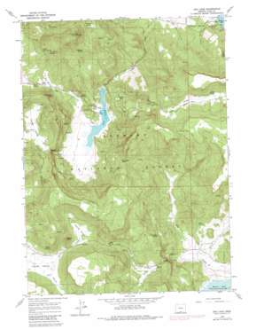
Dog Lake Topo Map Oregon
To zoom in, hover over the map of Dog Lake
USGS Topo Quad 42120a6 - 1:24,000 scale
| Topo Map Name: | Dog Lake |
| USGS Topo Quad ID: | 42120a6 |
| Print Size: | ca. 21 1/4" wide x 27" high |
| Southeast Coordinates: | 42° N latitude / 120.625° W longitude |
| Map Center Coordinates: | 42.0625° N latitude / 120.6875° W longitude |
| U.S. State: | OR |
| Filename: | o42120a6.jpg |
| Download Map JPG Image: | Dog Lake topo map 1:24,000 scale |
| Map Type: | Topographic |
| Topo Series: | 7.5´ |
| Map Scale: | 1:24,000 |
| Source of Map Images: | United States Geological Survey (USGS) |
| Alternate Map Versions: |
Dog Lake OR 1964, updated 1965 Download PDF Buy paper map Dog Lake OR 1964, updated 1980 Download PDF Buy paper map Dog Lake OR 2004, updated 2007 Download PDF Buy paper map Dog Lake OR 2011 Download PDF Buy paper map Dog Lake OR 2014 Download PDF Buy paper map |
| FStopo: | US Forest Service topo Dog Lake is available: Download FStopo PDF Download FStopo TIF |
1:24,000 Topo Quads surrounding Dog Lake
> Back to 42120a1 at 1:100,000 scale
> Back to 42120a1 at 1:250,000 scale
> Back to U.S. Topo Maps home
Dog Lake topo map: Gazetteer
Dog Lake: Gaps
Buckaroo Pass elevation 1809m 5935′Dog Lake: Lakes
Dog Lake elevation 1585m 5200′Little Lakes elevation 1647m 5403′
Dog Lake: Parks
Campground Number One (historical) elevation 1591m 5219′Campground Number Two (historical) elevation 1598m 5242′
Dog Lake: Springs
Adams Spring elevation 1893m 6210′Big Dog Spring elevation 1855m 6085′
Cold Spring elevation 1726m 5662′
Dog Lake Burn Spring elevation 1659m 5442′
Dog Lake Spring elevation 1739m 5705′
Hunter Spring elevation 1656m 5433′
Jerry Spring elevation 1621m 5318′
Kitty Spring elevation 1604m 5262′
Little Dog Spring elevation 1760m 5774′
Mine Spring elevation 1554m 5098′
Navy Spring elevation 1790m 5872′
Nick Barry Spring elevation 1780m 5839′
Scotts Cabin Spring elevation 1530m 5019′
Slash Spring elevation 1693m 5554′
Telephone Spring elevation 1880m 6167′
Upper Road Spring elevation 1688m 5538′
White Spring elevation 1643m 5390′
Dog Lake: Streams
Dog Mountain Creek elevation 1586m 5203′Fall Creek elevation 1519m 4983′
Green Creek elevation 1586m 5203′
Horseshoe Creek elevation 1540m 5052′
McCoin Creek elevation 1516m 4973′
Scotts Cabin Creek elevation 1499m 4917′
Dog Lake: Summits
Castle Rock elevation 1804m 5918′Dog Mountain elevation 2092m 6863′
Dog Lake: Valleys
Fall Valley elevation 1633m 5357′Green Valley elevation 1640m 5380′
South Arm Yokum Valley elevation 1638m 5374′
Young Valley elevation 1656m 5433′
Dog Lake digital topo map on disk
Buy this Dog Lake topo map showing relief, roads, GPS coordinates and other geographical features, as a high-resolution digital map file on DVD:


