Drake Peak Topo Map Oregon
To zoom in, hover over the map of Drake Peak
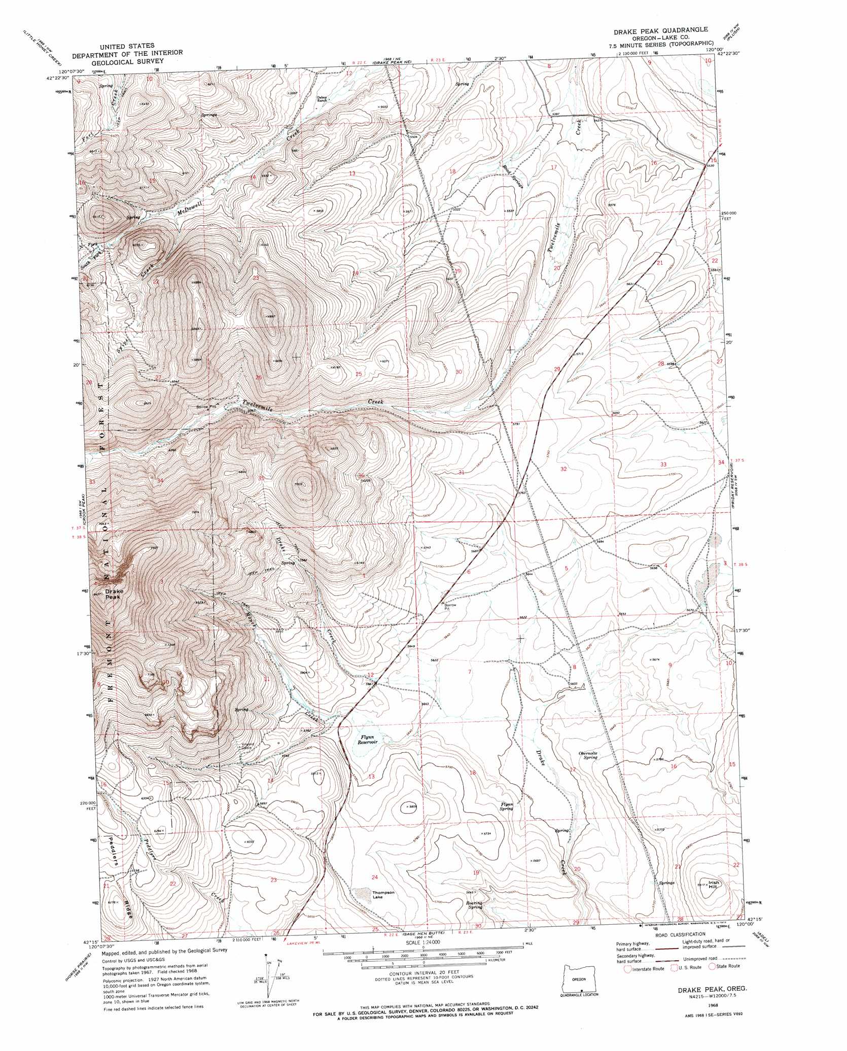
USGS Topo Quad 42120c1 - 1:24,000 scale
| Topo Map Name: | Drake Peak |
| USGS Topo Quad ID: | 42120c1 |
| Print Size: | ca. 21 1/4" wide x 27" high |
| Southeast Coordinates: | 42.25° N latitude / 120° W longitude |
| Map Center Coordinates: | 42.3125° N latitude / 120.0625° W longitude |
| U.S. State: | OR |
| Filename: | o42120c1.jpg |
| Download Map JPG Image: | Drake Peak topo map 1:24,000 scale |
| Map Type: | Topographic |
| Topo Series: | 7.5´ |
| Map Scale: | 1:24,000 |
| Source of Map Images: | United States Geological Survey (USGS) |
| Alternate Map Versions: |
Drake Peak OR 1968, updated 1972 Download PDF Buy paper map Drake Peak OR 2004, updated 2007 Download PDF Buy paper map Drake Peak OR 2011 Download PDF Buy paper map Drake Peak OR 2014 Download PDF Buy paper map |
| FStopo: | US Forest Service topo Drake Peak is available: Download FStopo PDF Download FStopo TIF |
1:24,000 Topo Quads surrounding Drake Peak
Coglan Buttes Se |
Lake Abert South |
Cooper Draw |
Rabbit Hills Sw |
Flagstaff Lake |
Valley Falls |
Little Honey Creek |
Drake Peak Ne |
Plush |
Hart Lake |
Crooked Creek Valley |
Crook Peak |
Drake Peak |
Priday Reservoir |
Crump Lake |
Lakeview |
Horse Prairie |
Sage Hen Butte |
Adel |
Calderwood Reservoir |
Crane Creek |
Crane Mountain |
Collins Rim |
May Lake |
Coleman Lake |
> Back to 42120a1 at 1:100,000 scale
> Back to 42120a1 at 1:250,000 scale
> Back to U.S. Topo Maps home
Drake Peak topo map: Gazetteer
Drake Peak: Dams
Flynn Dam elevation 1720m 5643′Drake Peak: Flats
Thompson Lake elevation 1761m 5777′Drake Peak: Reservoirs
Deboy Reservoir elevation 1707m 5600′Flynn Reservoir elevation 1720m 5643′
Game Reservoir elevation 1714m 5623′
State Game Reservoir Number Two elevation 1719m 5639′
Drake Peak: Ridges
Peddlers Ridge elevation 1912m 6272′Drake Peak: Springs
Flynn Spring elevation 1718m 5636′Obernolte Spring elevation 1731m 5679′
Road Springs elevation 1663m 5456′
Roaring Spring elevation 1695m 5561′
Drake Peak: Streams
Mapes Creek elevation 1712m 5616′North Fork McDowell Creek elevation 1795m 5889′
South Fork McDowell Creek elevation 1795m 5889′
Suipe Creek elevation 1751m 5744′
Drake Peak: Summits
Drake Peak elevation 2560m 8398′Irish Hill elevation 1802m 5912′
Drake Peak digital topo map on disk
Buy this Drake Peak topo map showing relief, roads, GPS coordinates and other geographical features, as a high-resolution digital map file on DVD: