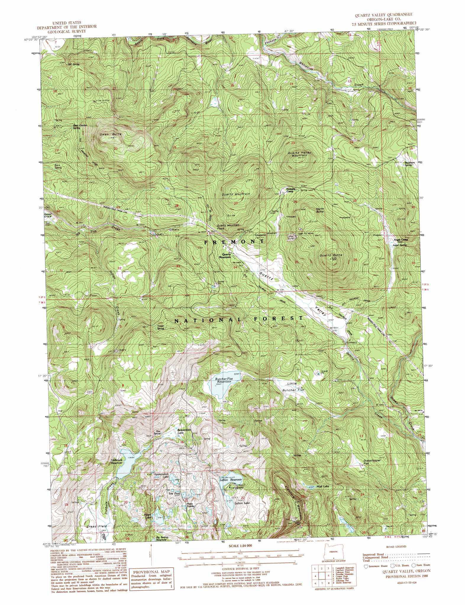
Quartz Valley Topo Map Oregon
To zoom in, hover over the map of Quartz Valley
USGS Topo Quad 42120c7 - 1:24,000 scale
| Topo Map Name: | Quartz Valley |
| USGS Topo Quad ID: | 42120c7 |
| Print Size: | ca. 21 1/4" wide x 27" high |
| Southeast Coordinates: | 42.25° N latitude / 120.75° W longitude |
| Map Center Coordinates: | 42.3125° N latitude / 120.8125° W longitude |
| U.S. State: | OR |
| Filename: | o42120c7.jpg |
| Download Map JPG Image: | Quartz Valley topo map 1:24,000 scale |
| Map Type: | Topographic |
| Topo Series: | 7.5´ |
| Map Scale: | 1:24,000 |
| Source of Map Images: | United States Geological Survey (USGS) |
| Alternate Map Versions: |
Quartz Valley OR 1988, updated 1988 Download PDF Buy paper map Quartz Valley OR 2004, updated 2007 Download PDF Buy paper map Quartz Valley OR 2011 Download PDF Buy paper map Quartz Valley OR 2014 Download PDF Buy paper map |
| FStopo: | US Forest Service topo Quartz Valley is available: Download FStopo PDF Download FStopo TIF |
1:24,000 Topo Quads surrounding Quartz Valley
Rodeo Butte |
Sandhill Crossing |
Lee Thomas Crossing |
Coffeepot Creek |
Morgan Butte |
Bly |
Campbell Reservoir |
Gearhart Mountain |
Coleman Point |
Shoestring Butte |
Horsefly Mountain |
Paradise Mountain |
Quartz Valley |
Cougar Peak |
Cox Flat |
Gerber Reservoir |
Barnes Valley |
Arkansas Flat |
Drews Reservoir |
Drews Gap |
Brady Butte |
Antler Point |
Strawberry Butte |
Dog Lake |
Fitzwater Point |
> Back to 42120a1 at 1:100,000 scale
> Back to 42120a1 at 1:250,000 scale
> Back to U.S. Topo Maps home
Quartz Valley topo map: Gazetteer
Quartz Valley: Dams
Dallas Lake Dam elevation 1695m 5561′Holbrook Dam elevation 1658m 5439′
Lofton Dam elevation 1875m 6151′
Ornoname 2 Dam elevation 1656m 5433′
Quartz Valley: Flats
Butcher Flat (historical) elevation 1702m 5583′Grasshopper Flat elevation 1678m 5505′
Little Butcher Flat elevation 1652m 5419′
Quartz Valley: Gaps
Quartz Mountain Pass elevation 1680m 5511′Quartz Valley: Lakes
Heart Lake elevation 1763m 5784′Lofton Lake elevation 1876m 6154′
Mud Lake elevation 1895m 6217′
Petes Puddle elevation 1811m 5941′
Spatterdock Lake elevation 1797m 5895′
Tule Pond elevation 1810m 5938′
Quartz Valley: Populated Places
Quartz Mountain elevation 1652m 5419′Quartz Valley: Post Offices
Quartz Mountain Post Office (historical) elevation 1652m 5419′Quartz Valley: Reservoirs
Butcher Flat Reservoir elevation 1690m 5544′Dallas Lake elevation 1695m 5561′
Holbrook Reservoir elevation 1658m 5439′
Lofton Reservoir elevation 1875m 6151′
Quartz Valley: Springs
Angel Spring elevation 1664m 5459′Beer Garden Spring elevation 1612m 5288′
Bill Spring elevation 1593m 5226′
Buckhorn Spring elevation 1824m 5984′
Doe Spring elevation 1709m 5606′
Fern Spring elevation 1545m 5068′
Tower Spring elevation 1840m 6036′
Quartz Valley: Streams
Indigo Creek elevation 1536m 5039′Quartz Creek elevation 1530m 5019′
Whitworth Creek elevation 1541m 5055′
Quartz Valley: Summits
Fishhole Mountain elevation 2154m 7066′North Butte elevation 1807m 5928′
Owen Butte elevation 1844m 6049′
Quartz Butte elevation 1913m 6276′
Quartz Mountain elevation 1844m 6049′
Quartz Valley Mountain elevation 1872m 6141′
Quartz Valley: Swamps
Beaverdam Lake elevation 1694m 5557′Quartz Valley: Valleys
Quartz Valley elevation 1612m 5288′Quartz Valley digital topo map on disk
Buy this Quartz Valley topo map showing relief, roads, GPS coordinates and other geographical features, as a high-resolution digital map file on DVD: