Valley Falls Topo Map Oregon
To zoom in, hover over the map of Valley Falls
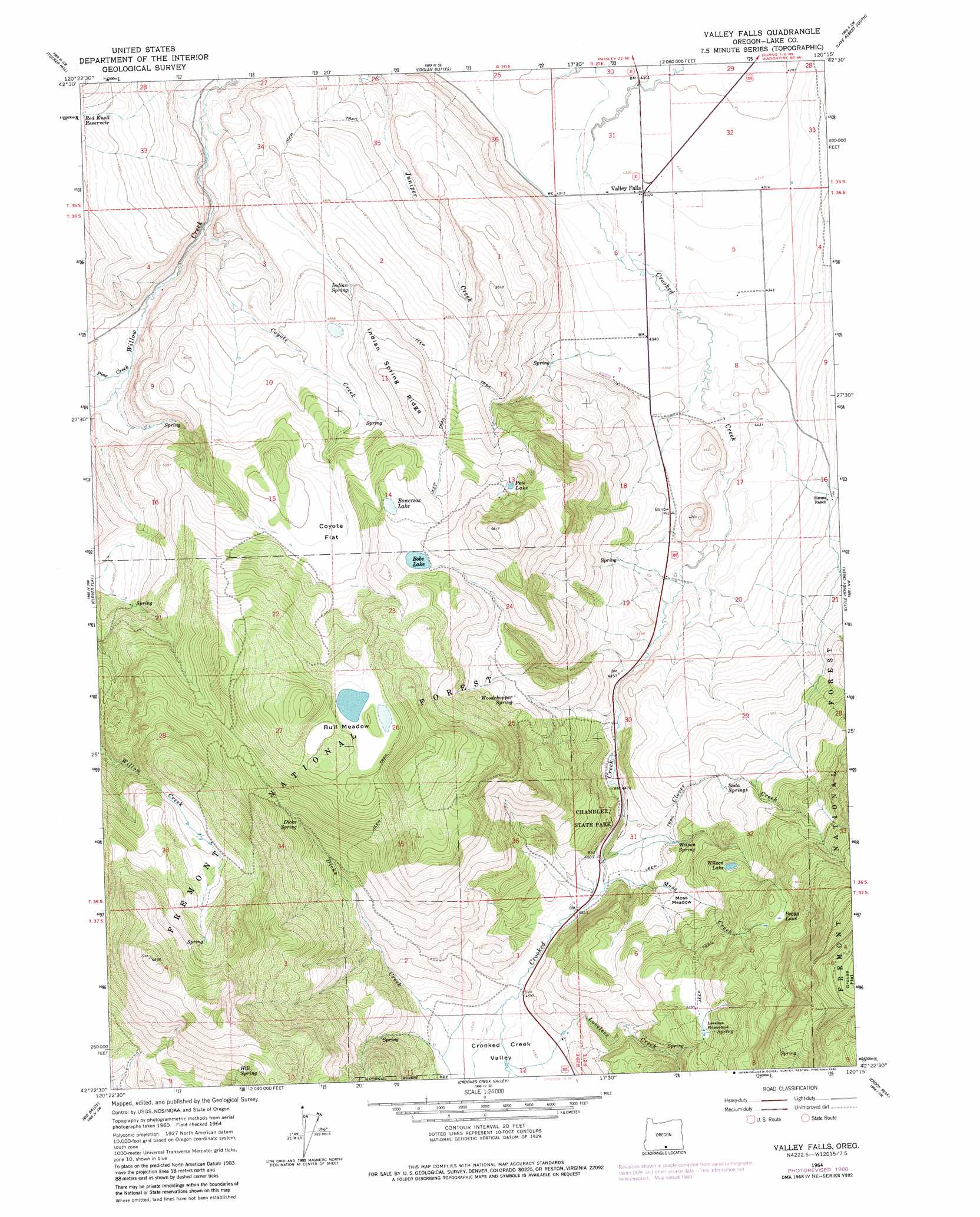
USGS Topo Quad 42120d3 - 1:24,000 scale
| Topo Map Name: | Valley Falls |
| USGS Topo Quad ID: | 42120d3 |
| Print Size: | ca. 21 1/4" wide x 27" high |
| Southeast Coordinates: | 42.375° N latitude / 120.25° W longitude |
| Map Center Coordinates: | 42.4375° N latitude / 120.3125° W longitude |
| U.S. State: | OR |
| Filename: | o42120d3.jpg |
| Download Map JPG Image: | Valley Falls topo map 1:24,000 scale |
| Map Type: | Topographic |
| Topo Series: | 7.5´ |
| Map Scale: | 1:24,000 |
| Source of Map Images: | United States Geological Survey (USGS) |
| Alternate Map Versions: |
Valley Falls OR 1964, updated 1965 Download PDF Buy paper map Valley Falls OR 1964, updated 1980 Download PDF Buy paper map Valley Falls OR 2004, updated 2007 Download PDF Buy paper map Valley Falls OR 2011 Download PDF Buy paper map Valley Falls OR 2014 Download PDF Buy paper map |
| FStopo: | US Forest Service topo Valley Falls is available: Download FStopo PDF Download FStopo TIF |
1:24,000 Topo Quads surrounding Valley Falls
Paisley |
Coglan Buttes |
Coglan Buttes Ne |
Lake Abert North |
Commodore Ridge |
Morgan Butte |
Tucker Hill |
Coglan Buttes Se |
Lake Abert South |
Cooper Draw |
Shoestring Butte |
Clover Flat |
Valley Falls |
Little Honey Creek |
Drake Peak Ne |
Cox Flat |
Big Baldy |
Crooked Creek Valley |
Crook Peak |
Drake Peak |
Drews Gap |
Lakeview Airport |
Lakeview |
Horse Prairie |
Sage Hen Butte |
> Back to 42120a1 at 1:100,000 scale
> Back to 42120a1 at 1:250,000 scale
> Back to U.S. Topo Maps home
Valley Falls topo map: Gazetteer
Valley Falls: Canals
High Line Ditch elevation 1473m 4832′Valley Falls: Flats
Bull Meadow elevation 1702m 5583′Coyote Flat elevation 1578m 5177′
Grouse Flat elevation 1996m 6548′
Moss Meadow elevation 1476m 4842′
Valley Falls: Lakes
Bobs Lake elevation 1639m 5377′Boggy Lake elevation 1670m 5479′
Bowersox Lake elevation 1622m 5321′
Mill Lake elevation 1699m 5574′
Wilson Lake elevation 1554m 5098′
Valley Falls: Parks
Chandler State Park elevation 1369m 4491′Valley Falls: Populated Places
Valley Falls elevation 1319m 4327′Valley Falls: Post Offices
Valley Falls Post Office (historical) elevation 1319m 4327′Valley Falls: Reservoirs
Coyote Flat Reservoir elevation 1492m 4895′Pete Lake elevation 1615m 5298′
Reynolds Reservoir elevation 1406m 4612′
Valley Falls: Ridges
Indian Spring Ridge elevation 1598m 5242′Valley Falls: Springs
Dicks Spring elevation 1566m 5137′Hill Spring elevation 1777m 5830′
Indian Spring elevation 1496m 4908′
Soda Springs elevation 1520m 4986′
Wilson Spring elevation 1436m 4711′
Woodchopper Spring elevation 1542m 5059′
Valley Falls: Streams
Clover Creek elevation 1368m 4488′Coyote Creek elevation 1372m 4501′
Dicks Creek elevation 1383m 4537′
Loveless Creek elevation 1387m 4550′
Moss Creek elevation 1375m 4511′
Pine Creek elevation 1386m 4547′
Valley Falls: Valleys
Crooked Creek Valley elevation 1381m 4530′Valley Falls digital topo map on disk
Buy this Valley Falls topo map showing relief, roads, GPS coordinates and other geographical features, as a high-resolution digital map file on DVD: