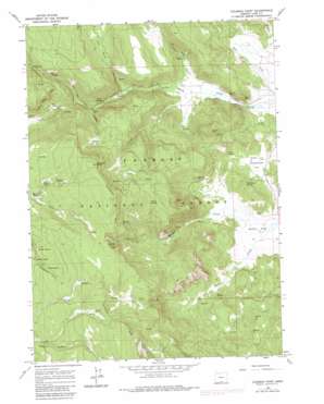
Coleman Point Topo Map Oregon
To zoom in, hover over the map of Coleman Point
USGS Topo Quad 42120d6 - 1:24,000 scale
| Topo Map Name: | Coleman Point |
| USGS Topo Quad ID: | 42120d6 |
| Print Size: | ca. 21 1/4" wide x 27" high |
| Southeast Coordinates: | 42.375° N latitude / 120.625° W longitude |
| Map Center Coordinates: | 42.4375° N latitude / 120.6875° W longitude |
| U.S. State: | OR |
| Filename: | o42120d6.jpg |
| Download Map JPG Image: | Coleman Point topo map 1:24,000 scale |
| Map Type: | Topographic |
| Topo Series: | 7.5´ |
| Map Scale: | 1:24,000 |
| Source of Map Images: | United States Geological Survey (USGS) |
| Alternate Map Versions: |
Coleman Point OR 1964, updated 1965 Download PDF Buy paper map Coleman Point OR 2004, updated 2007 Download PDF Buy paper map Coleman Point OR 2011 Download PDF Buy paper map Coleman Point OR 2014 Download PDF Buy paper map |
| FStopo: | US Forest Service topo Coleman Point is available: Download FStopo PDF Download FStopo TIF |
1:24,000 Topo Quads surrounding Coleman Point
> Back to 42120a1 at 1:100,000 scale
> Back to 42120a1 at 1:250,000 scale
> Back to U.S. Topo Maps home
Coleman Point topo map: Gazetteer
Coleman Point: Flats
Grasshopper Flat elevation 1597m 5239′Lantern Flat elevation 1948m 6391′
Picture Flat elevation 1707m 5600′
South Flat elevation 1586m 5203′
Coleman Point: Springs
Barrel Spring elevation 1842m 6043′Bean Spring elevation 1625m 5331′
Blonde Spring elevation 1907m 6256′
Brush Spring elevation 1835m 6020′
Clear Spring elevation 1658m 5439′
Cliff Spring elevation 1641m 5383′
Coleman Spring elevation 1950m 6397′
Colt Spring elevation 1829m 6000′
Eagle Spring elevation 1885m 6184′
Grasshopper Spring elevation 1623m 5324′
Morgan Spring elevation 1714m 5623′
Road Spring elevation 1910m 6266′
Round Spring elevation 1882m 6174′
Snag Spring elevation 1730m 5675′
Coleman Point: Streams
Augur Creek elevation 1591m 5219′Dead Horse Creek elevation 1790m 5872′
Deer Creek elevation 1666m 5465′
Morgan Creek elevation 1583m 5193′
North Fork Augur Creek elevation 1718m 5636′
Spring Creek elevation 1598m 5242′
Teepee Creek elevation 1654m 5426′
Coleman Point: Summits
Coleman Point elevation 2102m 6896′Dairy Point elevation 1716m 5629′
Drum Hill elevation 1921m 6302′
Coleman Point digital topo map on disk
Buy this Coleman Point topo map showing relief, roads, GPS coordinates and other geographical features, as a high-resolution digital map file on DVD:


