Tucker Hill Topo Map Oregon
To zoom in, hover over the map of Tucker Hill
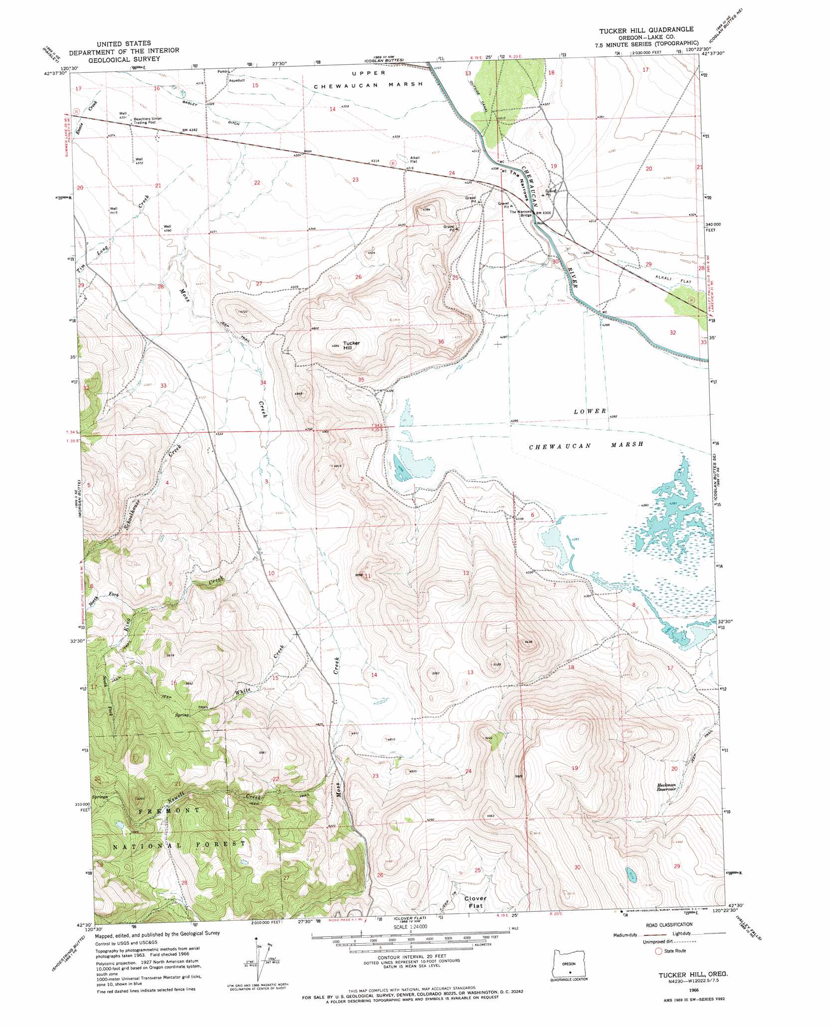
USGS Topo Quad 42120e4 - 1:24,000 scale
| Topo Map Name: | Tucker Hill |
| USGS Topo Quad ID: | 42120e4 |
| Print Size: | ca. 21 1/4" wide x 27" high |
| Southeast Coordinates: | 42.5° N latitude / 120.375° W longitude |
| Map Center Coordinates: | 42.5625° N latitude / 120.4375° W longitude |
| U.S. State: | OR |
| Filename: | o42120e4.jpg |
| Download Map JPG Image: | Tucker Hill topo map 1:24,000 scale |
| Map Type: | Topographic |
| Topo Series: | 7.5´ |
| Map Scale: | 1:24,000 |
| Source of Map Images: | United States Geological Survey (USGS) |
| Alternate Map Versions: |
Tucker Hill OR 1966, updated 1968 Download PDF Buy paper map Tucker Hill OR 2004, updated 2007 Download PDF Buy paper map Tucker Hill OR 2011 Download PDF Buy paper map Tucker Hill OR 2014 Download PDF Buy paper map |
| FStopo: | US Forest Service topo Tucker Hill is available: Download FStopo PDF Download FStopo TIF |
1:24,000 Topo Quads surrounding Tucker Hill
South Of Ana River |
Loco Lake |
Sharp Top |
Biscuit Point |
Sawed Horn |
Slide Mountain |
Paisley |
Coglan Buttes |
Coglan Buttes Ne |
Lake Abert North |
Coffeepot Creek |
Morgan Butte |
Tucker Hill |
Coglan Buttes Se |
Lake Abert South |
Coleman Point |
Shoestring Butte |
Clover Flat |
Valley Falls |
Little Honey Creek |
Cougar Peak |
Cox Flat |
Big Baldy |
Crooked Creek Valley |
Crook Peak |
> Back to 42120e1 at 1:100,000 scale
> Back to 42120a1 at 1:250,000 scale
> Back to U.S. Topo Maps home
Tucker Hill topo map: Gazetteer
Tucker Hill: Bridges
The Narrows Bridge elevation 1309m 4294′Tucker Hill: Canals
Lower Marsh Canal elevation 1307m 4288′Moss Ditch elevation 1452m 4763′
Tucker Hill: Gaps
The Narrows elevation 1313m 4307′Tucker Hill: Reservoirs
Heckman Reservoir elevation 1389m 4557′Heckman Reservoir Number One elevation 1485m 4872′
Tucker Hill: Streams
Ennis Creek elevation 1326m 4350′King Creek elevation 1374m 4507′
Moss Creek elevation 1320m 4330′
Newell Creek elevation 1479m 4852′
North Fork King Creek elevation 1553m 5095′
Schoolhouse Creek elevation 1355m 4445′
South Fork King Creek elevation 1597m 5239′
Tim Long Creek elevation 1328m 4356′
White Creek elevation 1408m 4619′
Tucker Hill: Summits
Tucker Hill elevation 1520m 4986′Tucker Hill: Swamps
Lower Chewaucan Marsh elevation 1308m 4291′Tucker Hill digital topo map on disk
Buy this Tucker Hill topo map showing relief, roads, GPS coordinates and other geographical features, as a high-resolution digital map file on DVD: