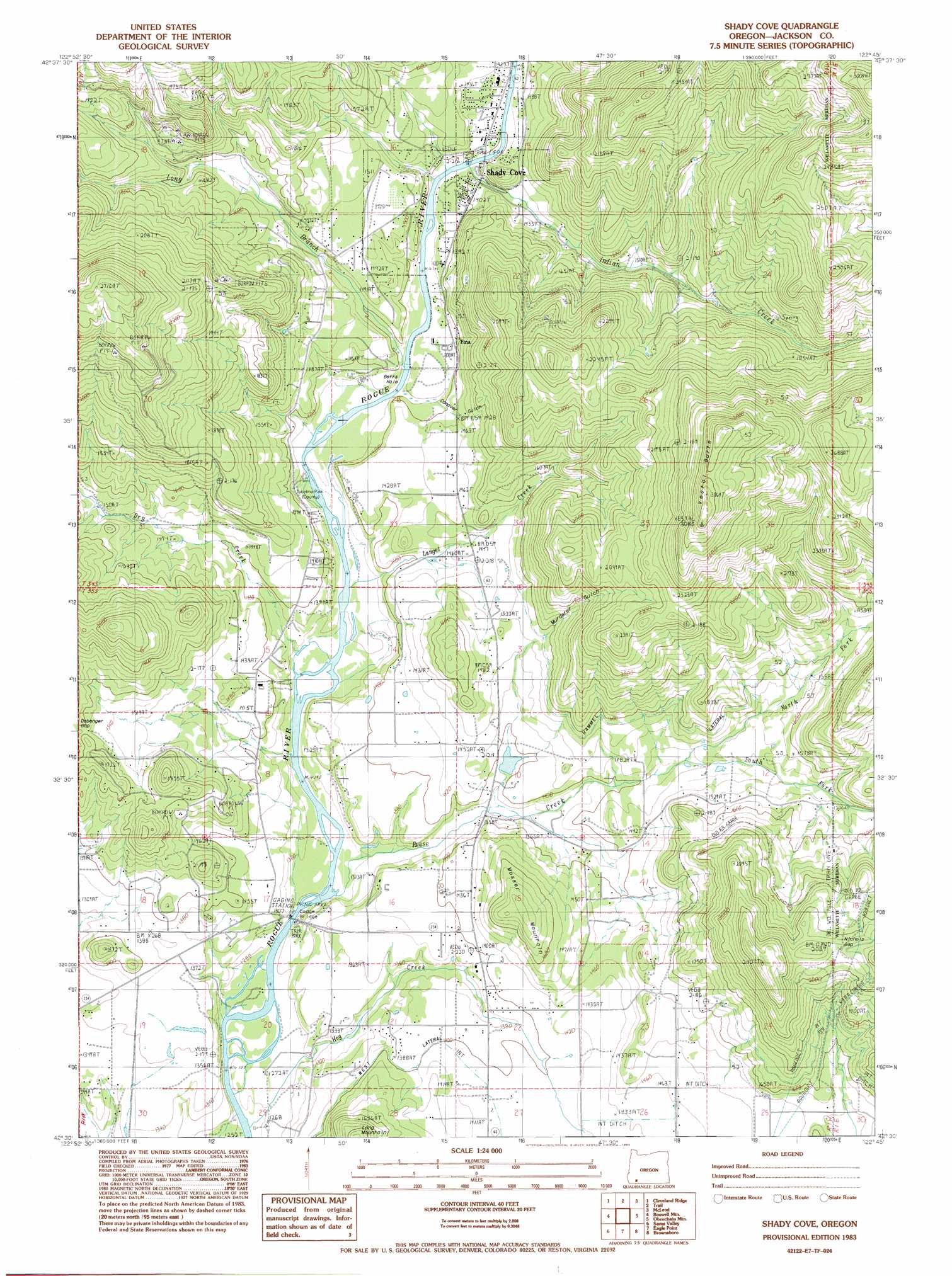
Shady Cove Topo Map Oregon
To zoom in, hover over the map of Shady Cove
USGS Topo Quad 42122e7 - 1:24,000 scale
| Topo Map Name: | Shady Cove |
| USGS Topo Quad ID: | 42122e7 |
| Print Size: | ca. 21 1/4" wide x 27" high |
| Southeast Coordinates: | 42.5° N latitude / 122.75° W longitude |
| Map Center Coordinates: | 42.5625° N latitude / 122.8125° W longitude |
| U.S. State: | OR |
| Filename: | o42122e7.jpg |
| Download Map JPG Image: | Shady Cove topo map 1:24,000 scale |
| Map Type: | Topographic |
| Topo Series: | 7.5´ |
| Map Scale: | 1:24,000 |
| Source of Map Images: | United States Geological Survey (USGS) |
| Alternate Map Versions: |
Shady Cove OR 1983, updated 1983 Download PDF Buy paper map Shady Cove OR 2011 Download PDF Buy paper map Shady Cove OR 2014 Download PDF Buy paper map |
1:24,000 Topo Quads surrounding Shady Cove
Cedar Springs Mountain |
Richter Mountain |
Ragsdale Butte |
Sugarpine Creek |
Whetstone Point |
Skeleton Mountain |
Cleveland Ridge |
Trail |
Mcleod |
Cascade Gorge |
Mcconville Peak |
Boswell Mountain |
Shady Cove |
Obenchain Mountain |
Butte Falls |
Gold Hill |
Sams Valley |
Eagle Point |
Brownsboro |
Lakecreek |
Mount Isabelle |
Medford West |
Medford East |
Rio Canyon |
Grizzly Peak |
> Back to 42122e1 at 1:100,000 scale
> Back to 42122a1 at 1:250,000 scale
> Back to U.S. Topo Maps home
Shady Cove topo map: Gazetteer
Shady Cove: Airports
Mountain View Air Park elevation 432m 1417′Rogue-Air Airport elevation 460m 1509′
Shady Cove: Bridges
Dodge Bridge elevation 390m 1279′Shady Cove: Canals
Hammel Lateral elevation 492m 1614′Pettegrew Lateral elevation 465m 1525′
Shady Cove: Channels
Betts Hole elevation 415m 1361′Shady Cove: Dams
Hamel Dam Number 2 (historical) elevation 436m 1430′Shady Cove: Gaps
Debenger Gap elevation 481m 1578′Nichols Gap elevation 637m 2089′
Shady Cove: Parks
Dodge Bridge County Park elevation 390m 1279′Shady Park elevation 432m 1417′
Takelma County Park elevation 410m 1345′
Upper Rogue Regional County Park elevation 426m 1397′
Shady Cove: Populated Places
Etna (historical) elevation 421m 1381′Shady Cove elevation 427m 1400′
Shady Cove: Post Offices
Etna Post Office (historical) elevation 421m 1381′Shady Cove Post Office elevation 427m 1400′
Shady Cove: Reservoirs
Gates Reservoir elevation 414m 1358′Hamel Reservoir Number 2 (historical) elevation 436m 1430′
Hammel Reservoir elevation 423m 1387′
Humphrey Reservoirs elevation 441m 1446′
Robinson Reservoir elevation 473m 1551′
Sims Reservoir elevation 488m 1601′
Todd Reservoir elevation 421m 1381′
Weltman Reservoir elevation 420m 1377′
Shady Cove: Springs
Ball Spring elevation 463m 1519′Shady Cove: Streams
Dry Creek elevation 403m 1322′Hog Creek elevation 382m 1253′
Indian Creek elevation 424m 1391′
Langel Creek elevation 405m 1328′
Long Branch elevation 415m 1361′
North Fork Reese Creek elevation 437m 1433′
Reese Creek elevation 396m 1299′
South Fork Reese Creek elevation 437m 1433′
Shady Cove: Summits
Mosser Mountain elevation 537m 1761′Vestal Butte elevation 931m 3054′
Shady Cove: Valleys
Conover Gulch elevation 415m 1361′Murderer Gulch elevation 459m 1505′
Shady Cove digital topo map on disk
Buy this Shady Cove topo map showing relief, roads, GPS coordinates and other geographical features, as a high-resolution digital map file on DVD: