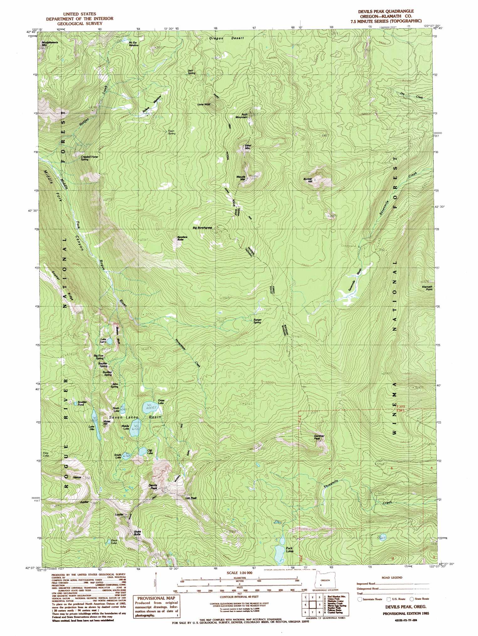
Devils Peak Topo Map Oregon
To zoom in, hover over the map of Devils Peak
USGS Topo Quad 42122f2 - 1:24,000 scale
| Topo Map Name: | Devils Peak |
| USGS Topo Quad ID: | 42122f2 |
| Print Size: | ca. 21 1/4" wide x 27" high |
| Southeast Coordinates: | 42.625° N latitude / 122.125° W longitude |
| Map Center Coordinates: | 42.6875° N latitude / 122.1875° W longitude |
| U.S. State: | OR |
| Filename: | o42122f2.jpg |
| Download Map JPG Image: | Devils Peak topo map 1:24,000 scale |
| Map Type: | Topographic |
| Topo Series: | 7.5´ |
| Map Scale: | 1:24,000 |
| Source of Map Images: | United States Geological Survey (USGS) |
| Alternate Map Versions: |
Devils Peak OR 1985, updated 1985 Download PDF Buy paper map Devils Peak OR 1998, updated 2000 Download PDF Buy paper map Devils Peak OR 2011 Download PDF Buy paper map Devils Peak OR 2014 Download PDF Buy paper map |
| FStopo: | US Forest Service topo Devils Peak is available: Download FStopo PDF Download FStopo TIF |
1:24,000 Topo Quads surrounding Devils Peak
Union Creek |
Thousand Springs |
Crater Lake West |
Crater Lake East |
Pothole Butte |
Prospect North |
Red Blanket Mountain |
Union Peak |
Maklaks Crater |
Sun Pass |
Prospect South |
Imnaha Creek |
Devils Peak |
Mares Egg Spring |
Fort Klamath |
Big Butte Springs |
Rustler Peak |
Pelican Butte |
Crystal Spring |
Agency Lake |
Willow Lake |
Mount Mcloughlin |
Lake Of The Woods North |
Pelican Bay |
Shoalwater Bay |
> Back to 42122e1 at 1:100,000 scale
> Back to 42122a1 at 1:250,000 scale
> Back to U.S. Topo Maps home
Devils Peak topo map: Gazetteer
Devils Peak: Basins
Seven Lakes Basin elevation 1867m 6125′Devils Peak: Cliffs
Boston Bluff elevation 1745m 5725′Devils Peak: Lakes
Boulder Pond elevation 2035m 6676′Cliff Lake elevation 1913m 6276′
Finch Lake elevation 2010m 6594′
Grass Lake elevation 1832m 6010′
Lake Alta elevation 2082m 6830′
Lake Ivern elevation 1743m 5718′
Middle Lake elevation 1861m 6105′
North Lake elevation 1851m 6072′
Puck Lakes elevation 1972m 6469′
South Lake elevation 1948m 6391′
Devils Peak: Parks
Alta Campground (historical) elevation 2075m 6807′Cliff Lake Campground (historical) elevation 1918m 6292′
Grass Lake Campground (historical) elevation 1833m 6013′
Grass Lake Campground Number 2 (historical) elevation 1850m 6069′
South Lake Campground (historical) elevation 1950m 6397′
Devils Peak: Plains
Oregon Desert elevation 1849m 6066′Devils Peak: Ridges
Gopher Ridge elevation 1893m 6210′Devils Peak: Springs
Crippled Horse Spring elevation 1548m 5078′Ranger Spring elevation 1730m 5675′
Devils Peak: Streams
Honeymoon Creek elevation 1615m 5298′Devils Peak: Summits
Bareface Butte elevation 1929m 6328′Big Bunchgrass elevation 2000m 6561′
Bunker Hill elevation 1976m 6482′
Devils Peak elevation 2300m 7545′
Ethel Mountain elevation 2090m 6856′
Gardner Peak elevation 2092m 6863′
Jupiter elevation 2256m 7401′
Klamath Point elevation 2192m 7191′
Lee Peak elevation 2282m 7486′
Lone Wolf elevation 1975m 6479′
Lucifer elevation 2244m 7362′
Maude Mountain elevation 2121m 6958′
Ruth Mountain elevation 2047m 6715′
Shale Butte elevation 2238m 7342′
Venus elevation 2225m 7299′
Violet Hill elevation 2091m 6860′
Devils Peak: Swamps
Sevenmile Marsh elevation 1703m 5587′Devils Peak: Trails
Alta Lake Trail elevation 1924m 6312′Dry Creek Trail elevation 1723m 5652′
Halifax Trail elevation 1637m 5370′
Moude Mountain Trail elevation 1788m 5866′
Sevenmile Trail elevation 1720m 5643′
Devils Peak digital topo map on disk
Buy this Devils Peak topo map showing relief, roads, GPS coordinates and other geographical features, as a high-resolution digital map file on DVD: