Prospect South Topo Map Oregon
To zoom in, hover over the map of Prospect South
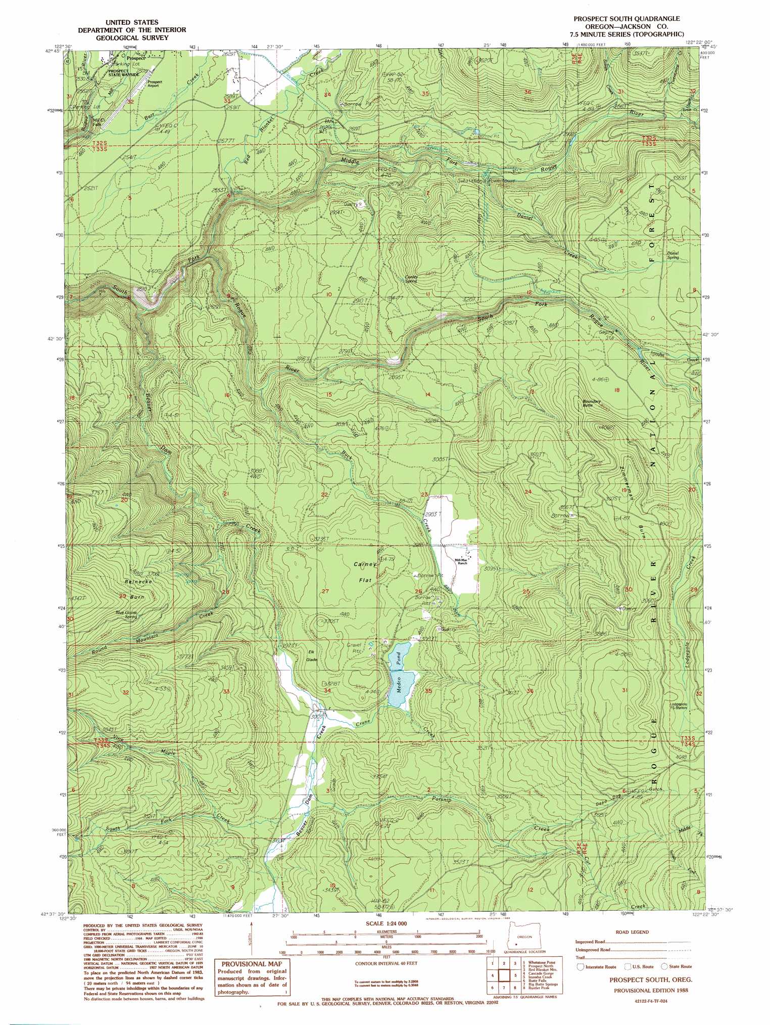
USGS Topo Quad 42122f4 - 1:24,000 scale
| Topo Map Name: | Prospect South |
| USGS Topo Quad ID: | 42122f4 |
| Print Size: | ca. 21 1/4" wide x 27" high |
| Southeast Coordinates: | 42.625° N latitude / 122.375° W longitude |
| Map Center Coordinates: | 42.6875° N latitude / 122.4375° W longitude |
| U.S. State: | OR |
| Filename: | o42122f4.jpg |
| Download Map JPG Image: | Prospect South topo map 1:24,000 scale |
| Map Type: | Topographic |
| Topo Series: | 7.5´ |
| Map Scale: | 1:24,000 |
| Source of Map Images: | United States Geological Survey (USGS) |
| Alternate Map Versions: |
Prospect South OR 1988, updated 1988 Download PDF Buy paper map Prospect South OR 1997, updated 2000 Download PDF Buy paper map Prospect South OR 2011 Download PDF Buy paper map Prospect South OR 2014 Download PDF Buy paper map |
| FStopo: | US Forest Service topo Prospect South is available: Download FStopo PDF Download FStopo TIF |
1:24,000 Topo Quads surrounding Prospect South
Butler Butte |
Abbott Butte |
Union Creek |
Thousand Springs |
Crater Lake West |
Sugarpine Creek |
Whetstone Point |
Prospect North |
Red Blanket Mountain |
Union Peak |
Mcleod |
Cascade Gorge |
Prospect South |
Imnaha Creek |
Devils Peak |
Obenchain Mountain |
Butte Falls |
Big Butte Springs |
Rustler Peak |
Pelican Butte |
Brownsboro |
Lakecreek |
Willow Lake |
Mount Mcloughlin |
Lake Of The Woods North |
> Back to 42122e1 at 1:100,000 scale
> Back to 42122a1 at 1:250,000 scale
> Back to U.S. Topo Maps home
Prospect South topo map: Gazetteer
Prospect South: Areas
Reinecke Burn elevation 1221m 4005′Zimmerman Burn elevation 1232m 4041′
Prospect South: Dams
Dailey Dam elevation 931m 3054′South Fork Dam elevation 1037m 3402′
Prospect South: Falls
Barr Creek Falls elevation 772m 2532′Mill Creek Falls elevation 746m 2447′
Prospect South: Flats
Carney Flat elevation 968m 3175′Elk Glade elevation 957m 3139′
Prospect South: Lakes
Medco Pond elevation 931m 3054′Prospect South: Parks
Aiken County Park elevation 742m 2434′Prospect State Park elevation 784m 2572′
Prospect South: Springs
Blue Goose Spring elevation 1154m 3786′Conley Spring elevation 943m 3093′
Daniel Spring elevation 1080m 3543′
Prospect South: Streams
Ash Creek elevation 613m 2011′Barr Creek elevation 679m 2227′
Beaver Dam Creek elevation 623m 2043′
Bessie Creek elevation 892m 2926′
Buck Creek elevation 761m 2496′
Cod Creek elevation 771m 2529′
Crane Creek elevation 917m 3008′
Cur Creek elevation 1036m 3398′
Daniel Creek elevation 780m 2559′
Geppert Creek elevation 913m 2995′
Gyppo Creek elevation 851m 2791′
Imnaha Creek elevation 1024m 3359′
Middle Fork Parsnip Creek elevation 1238m 4061′
Middle Fork Rogue River elevation 666m 2185′
Mill Creek elevation 721m 2365′
Parsnip Creek elevation 927m 3041′
Red Blanket Creek elevation 704m 2309′
Round Mountain Creek elevation 837m 2746′
South Fork Parsnip Creek elevation 1241m 4071′
South Fork Vine Maple Creek elevation 989m 3244′
Svinth Creek elevation 824m 2703′
Twentynine Creek elevation 851m 2791′
Vine Maple Creek elevation 932m 3057′
Prospect South: Summits
Boundary Butte elevation 1174m 3851′Prospect South: Valleys
Dead Dog Gulch elevation 1114m 3654′Prospect South digital topo map on disk
Buy this Prospect South topo map showing relief, roads, GPS coordinates and other geographical features, as a high-resolution digital map file on DVD: