Trail Topo Map Oregon
To zoom in, hover over the map of Trail
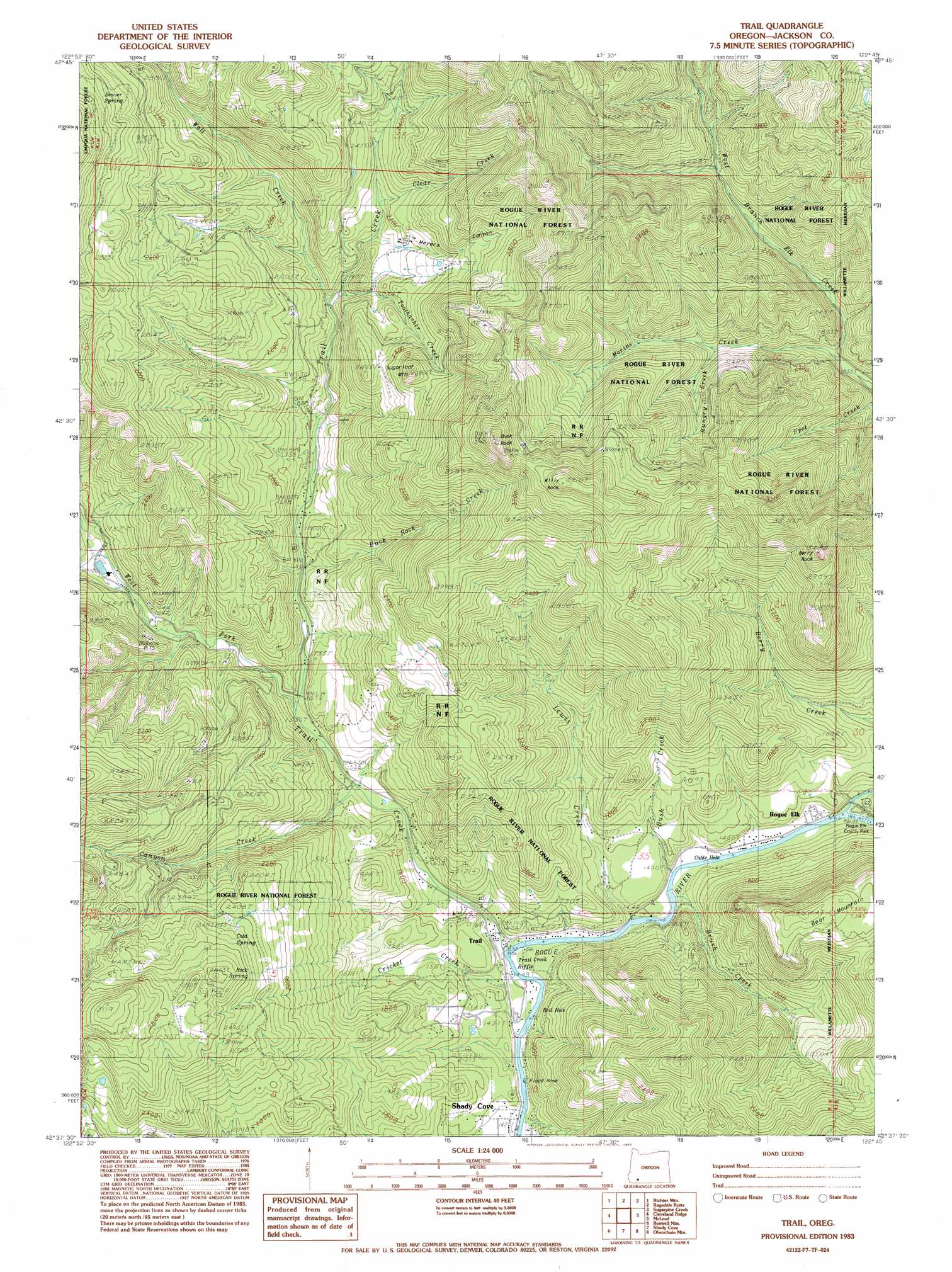
USGS Topo Quad 42122f7 - 1:24,000 scale
| Topo Map Name: | Trail |
| USGS Topo Quad ID: | 42122f7 |
| Print Size: | ca. 21 1/4" wide x 27" high |
| Southeast Coordinates: | 42.625° N latitude / 122.75° W longitude |
| Map Center Coordinates: | 42.6875° N latitude / 122.8125° W longitude |
| U.S. State: | OR |
| Filename: | o42122f7.jpg |
| Download Map JPG Image: | Trail topo map 1:24,000 scale |
| Map Type: | Topographic |
| Topo Series: | 7.5´ |
| Map Scale: | 1:24,000 |
| Source of Map Images: | United States Geological Survey (USGS) |
| Alternate Map Versions: |
Trail OR 1983, updated 1983 Download PDF Buy paper map Trail OR 1997, updated 2000 Download PDF Buy paper map Trail OR 2011 Download PDF Buy paper map Trail OR 2014 Download PDF Buy paper map |
| FStopo: | US Forest Service topo Trail is available: Download FStopo PDF Download FStopo TIF |
1:24,000 Topo Quads surrounding Trail
Milo |
Tiller |
Pickett Butte |
Butler Butte |
Abbott Butte |
Cedar Springs Mountain |
Richter Mountain |
Ragsdale Butte |
Sugarpine Creek |
Whetstone Point |
Skeleton Mountain |
Cleveland Ridge |
Trail |
Mcleod |
Cascade Gorge |
Mcconville Peak |
Boswell Mountain |
Shady Cove |
Obenchain Mountain |
Butte Falls |
Gold Hill |
Sams Valley |
Eagle Point |
Brownsboro |
Lakecreek |
> Back to 42122e1 at 1:100,000 scale
> Back to 42122a1 at 1:250,000 scale
> Back to U.S. Topo Maps home
Trail topo map: Gazetteer
Trail: Channels
Boil Hole elevation 439m 1440′Cable Hole elevation 448m 1469′
Trail: Parks
Rogue Elk County Park elevation 488m 1601′Trail: Pillars
Berry Rock elevation 1015m 3330′Buck Rock elevation 1163m 3815′
Flood Rock elevation 439m 1440′
Trail: Populated Places
Rogue Elk elevation 451m 1479′Trail elevation 439m 1440′
Trail: Post Offices
Trail Post Office elevation 439m 1440′Trail: Rapids
Trail Creek Riffle elevation 439m 1440′Trail: Springs
Beaver Spring elevation 874m 2867′Cold Spring elevation 748m 2454′
Rock Spring elevation 780m 2559′
Trail: Streams
Brush Creek elevation 441m 1446′Buck Rock Creek elevation 508m 1666′
Canyon Creek elevation 465m 1525′
Clear Creek elevation 663m 2175′
Cricket Creek elevation 439m 1440′
Cusick Creek elevation 440m 1443′
Elk Creek elevation 445m 1459′
Flat Creek elevation 477m 1564′
Hill Creek elevation 467m 1532′
Hungry Creek elevation 642m 2106′
Kendale Creek elevation 487m 1597′
Lewis Creek elevation 439m 1440′
Morine Creek elevation 564m 1850′
Paradise Creek elevation 509m 1669′
Toothacher Creek elevation 598m 1961′
Trail Creek elevation 439m 1440′
Wall Creek elevation 581m 1906′
West Fork Trail Creek elevation 477m 1564′
Trail: Summits
Bear Mountain elevation 818m 2683′Sugarloaf Mountain elevation 821m 2693′
Willy Rock elevation 1190m 3904′
Trail: Valleys
Myers Canyon elevation 643m 2109′Trail digital topo map on disk
Buy this Trail topo map showing relief, roads, GPS coordinates and other geographical features, as a high-resolution digital map file on DVD: