Crater Lake East Topo Map Oregon
To zoom in, hover over the map of Crater Lake East
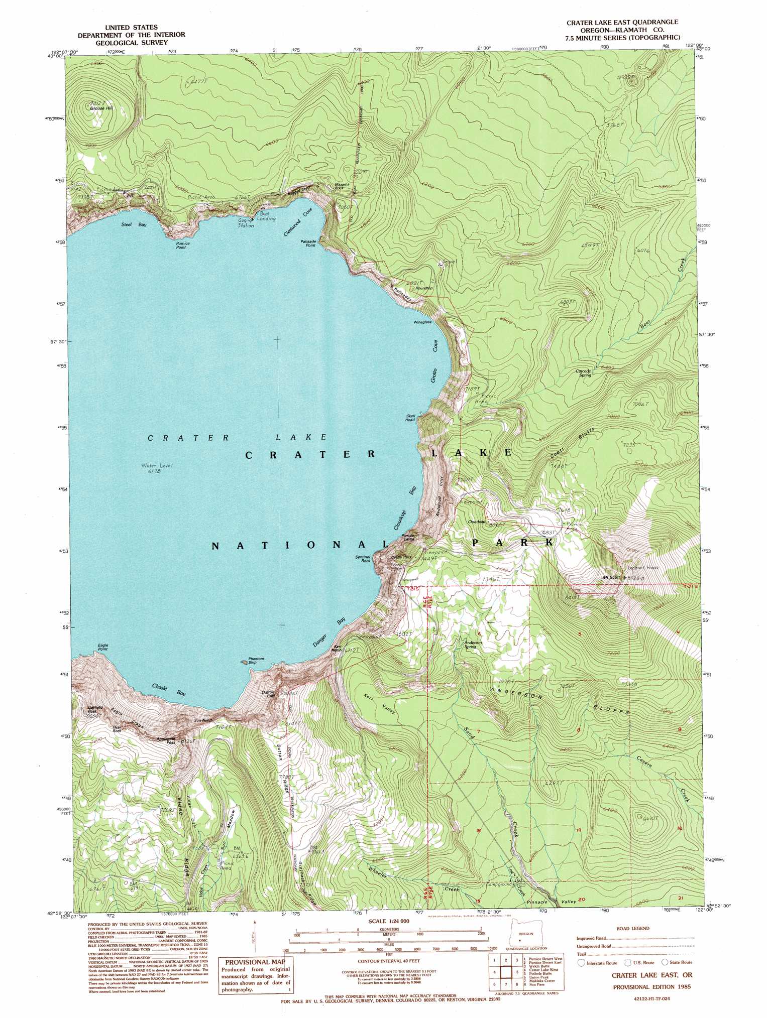
USGS Topo Quad 42122h1 - 1:24,000 scale
| Topo Map Name: | Crater Lake East |
| USGS Topo Quad ID: | 42122h1 |
| Print Size: | ca. 21 1/4" wide x 27" high |
| Southeast Coordinates: | 42.875° N latitude / 122° W longitude |
| Map Center Coordinates: | 42.9375° N latitude / 122.0625° W longitude |
| U.S. State: | OR |
| Filename: | o42122h1.jpg |
| Download Map JPG Image: | Crater Lake East topo map 1:24,000 scale |
| Map Type: | Topographic |
| Topo Series: | 7.5´ |
| Map Scale: | 1:24,000 |
| Source of Map Images: | United States Geological Survey (USGS) |
| Alternate Map Versions: |
Crater Lake East OR 1985, updated 1985 Download PDF Buy paper map Crater Lake East OR 1985, updated 1995 Download PDF Buy paper map Crater Lake East OR 1999, updated 2002 Download PDF Buy paper map Crater Lake East OR 2011 Download PDF Buy paper map Crater Lake East OR 2014 Download PDF Buy paper map |
| FStopo: | US Forest Service topo Crater Lake East is available: Download FStopo PDF Download FStopo TIF |
1:24,000 Topo Quads surrounding Crater Lake East
Garwood Butte |
Diamond Lake |
Mount Thielsen |
Miller Lake |
Chemult |
Hamaker Butte |
Pumice Desert West |
Pumice Desert East |
Welch Butte |
Mazama |
Thousand Springs |
Crater Lake West |
Crater Lake East |
Pothole Butte |
Lenz |
Red Blanket Mountain |
Union Peak |
Maklaks Crater |
Sun Pass |
Fuego |
Imnaha Creek |
Devils Peak |
Mares Egg Spring |
Fort Klamath |
Soloman Butte |
> Back to 42122e1 at 1:100,000 scale
> Back to 42122a1 at 1:250,000 scale
> Back to U.S. Topo Maps home
Crater Lake East topo map: Gazetteer
Crater Lake East: Areas
Base of Mount Mazama elevation 2009m 6591′Crater Lake East: Bays
Chaski Bay elevation 1885m 6184′Cleetwood Cove elevation 1885m 6184′
Cloudcap Bay elevation 1885m 6184′
Danger Bay elevation 1885m 6184′
Grotto Cove elevation 1885m 6184′
Steel Bay elevation 1885m 6184′
Crater Lake East: Capes
Eagle Point elevation 1963m 6440′Palisade Point elevation 1894m 6213′
Pumice Point elevation 1885m 6184′
Crater Lake East: Cliffs
Anderson Bluffs elevation 2055m 6742′Dutton Cliff elevation 2368m 7769′
Palisades elevation 1968m 6456′
Pumice Castle elevation 2124m 6968′
Redcloud Cliff elevation 2361m 7746′
Rugged Crest Palisades elevation 2003m 6571′
Scott Bluffs elevation 2200m 7217′
Skell Head elevation 1913m 6276′
Victor View elevation 2249m 7378′
Vidae Cliff elevation 2192m 7191′
Wineglass elevation 1944m 6377′
Crater Lake East: Flats
Sun Meadows elevation 2006m 6581′Crater Lake East: Gaps
Kerr Notch elevation 2037m 6683′Sun Notch elevation 2174m 7132′
Crater Lake East: Islands
Phantom Ship elevation 1885m 6184′Crater Lake East: Lakes
Crater Lake elevation 1885m 6184′Crater Lake East: Pillars
Castle Rock elevation 1885m 6184′Dyar Rock elevation 2371m 7778′
Sentinel Rock elevation 1959m 6427′
Crater Lake East: Ridges
Dutton Ridge elevation 2336m 7664′Rugged Crest elevation 2095m 6873′
Vidae Ridge elevation 2101m 6893′
Crater Lake East: Springs
Anderson Spring elevation 2105m 6906′Cascade Spring elevation 1987m 6519′
Lost Creek Spring elevation 1842m 6043′
Crater Lake East: Summits
Applegate Peak elevation 2450m 8038′Cloudcap elevation 2444m 8018′
Eagle Crags elevation 2060m 6758′
Garfield Peak elevation 2454m 8051′
Grouse Hill elevation 2256m 7401′
Mazama Rock elevation 2084m 6837′
Mount Mazama elevation 1885m 6184′
Mount Scott elevation 2636m 8648′
Roundtop elevation 2109m 6919′
Crater Lake East: Trails
Bear Creek Trail elevation 1974m 6476′Garfield Peak Trail elevation 2222m 7290′
Mount Scott Trail elevation 2305m 7562′
Sun Notch Trail elevation 2004m 6574′
Crater Lake East: Valleys
Kerr Valley elevation 1891m 6204′Crater Lake East digital topo map on disk
Buy this Crater Lake East topo map showing relief, roads, GPS coordinates and other geographical features, as a high-resolution digital map file on DVD: