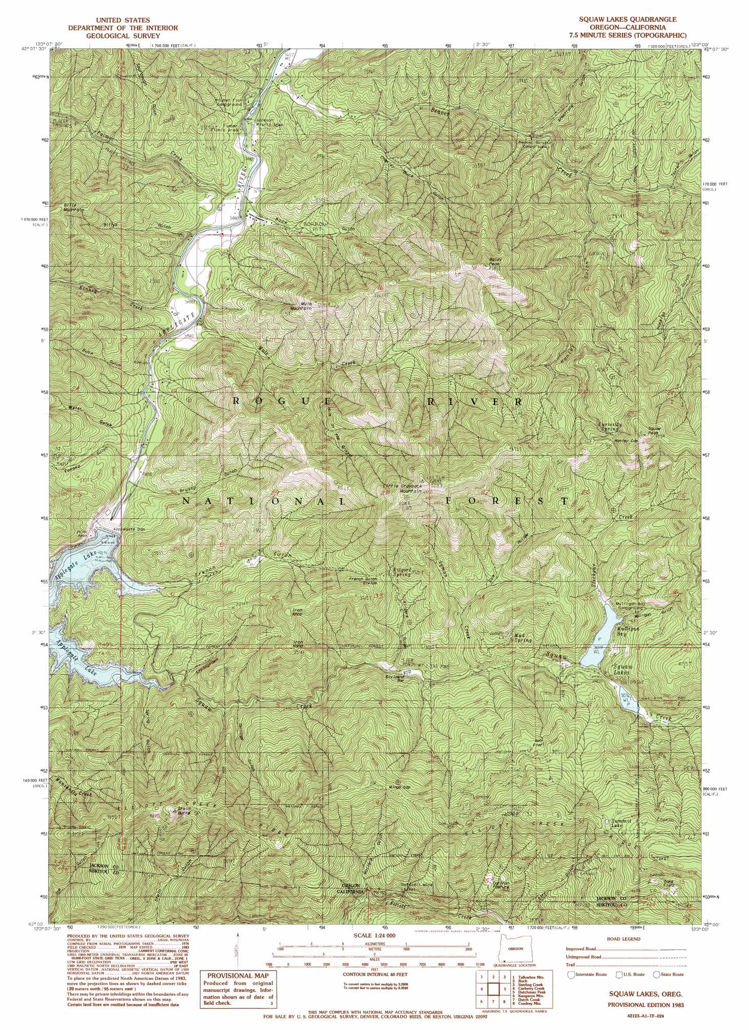
Squaw Lakes Topo Map Oregon
To zoom in, hover over the map of Squaw Lakes
USGS Topo Quad 42123a1 - 1:24,000 scale
| Topo Map Name: | Squaw Lakes |
| USGS Topo Quad ID: | 42123a1 |
| Print Size: | ca. 21 1/4" wide x 27" high |
| Southeast Coordinates: | 42° N latitude / 123° W longitude |
| Map Center Coordinates: | 42.0625° N latitude / 123.0625° W longitude |
| U.S. States: | OR, CA |
| Filename: | o42123a1.jpg |
| Download Map JPG Image: | Squaw Lakes topo map 1:24,000 scale |
| Map Type: | Topographic |
| Topo Series: | 7.5´ |
| Map Scale: | 1:24,000 |
| Source of Map Images: | United States Geological Survey (USGS) |
| Alternate Map Versions: |
Squaw Lakes OR 1983, updated 1983 Download PDF Buy paper map Squaw Lakes OR 1996, updated 1998 Download PDF Buy paper map Squaw Lakes OR 2011 Download PDF Buy paper map Squaw Lakes OR 2014 Download PDF Buy paper map |
| FStopo: | US Forest Service topo Squaw Lakes is available: Download FStopo PDF Download FStopo TIF |
1:24,000 Topo Quads surrounding Squaw Lakes
Murphy |
Applegate |
Mount Isabelle |
Medford West |
Medford East |
Williams |
Tallowbox Mountain |
Ruch |
Sterling Creek |
Talent |
Grayback Mountain |
Carberry Creek |
Squaw Lakes |
Dutchman Peak |
Siskiyou Peak |
Figurehead Mountain |
Kangaroo Mountain |
Dutch Creek |
Condrey Mountain |
Buckhorn Bally |
Slater Butte |
Seiad Valley |
Hamburg |
Horse Creek |
Mckinley Mountain |
> Back to 42123a1 at 1:100,000 scale
> Back to 42122a1 at 1:250,000 scale
> Back to U.S. Topo Maps home
Squaw Lakes topo map: Gazetteer
Squaw Lakes: Bays
Mulligan Bay elevation 962m 3156′Squaw Lakes: Dams
Applegate Dam elevation 594m 1948′Squaw Lakes Dam elevation 921m 3021′
Squaw Lakes: Flats
Ash Flat elevation 1188m 3897′Carlton Pasture elevation 1025m 3362′
Oak Flats elevation 1466m 4809′
Squaw Lakes: Gaps
French Gulch Divide elevation 993m 3257′Hanley Gap elevation 1302m 4271′
Mingo Gap elevation 1267m 4156′
Squaw Lakes: Lakes
Squaw Lakes elevation 921m 3021′Summit Lake elevation 1445m 4740′
Squaw Lakes: Mines
Daffodil Mine elevation 833m 2732′Daffodil Mine elevation 788m 2585′
Placer Mine elevation 569m 1866′
Squaw Lakes: Post Offices
Wright Post Office (historical) elevation 543m 1781′Squaw Lakes: Reservoirs
Applegate Lake elevation 594m 1948′Squaw Lakes: Ridges
Elliott Creek Ridge elevation 1375m 4511′Squaw Lakes: Springs
Curiosity Spring elevation 1288m 4225′Kilgore Spring elevation 930m 3051′
Mud Spring elevation 949m 3113′
Squaw Lakes: Streams
Beaver Creek elevation 504m 1653′Kinney Creek elevation 550m 1804′
Lyman Creek elevation 796m 2611′
Mule Creek elevation 526m 1725′
Palmer Creek elevation 514m 1686′
Slickear Creek elevation 921m 3021′
Squaw Creek elevation 601m 1971′
Squaw Lakes: Summits
Baldy Peak elevation 1407m 4616′Iron Hand elevation 1066m 3497′
Iron Knob elevation 1090m 3576′
Little Grayback Mountain elevation 1547m 5075′
Mule Mountain elevation 1052m 3451′
Squaw Peak elevation 1507m 4944′
Stein Butte elevation 1313m 4307′
Squaw Lakes: Trails
Calsh Trail elevation 719m 2358′Squaw Lakes: Valleys
Armstrong Gulch elevation 638m 2093′Billys Gulch elevation 577m 1893′
Black Gulch elevation 611m 2004′
Brushy Gulch elevation 558m 1830′
Charlie Buck Gulch elevation 598m 1961′
Collings Gulch elevation 659m 2162′
Doe Hollow elevation 902m 2959′
French Gulch elevation 594m 1948′
Hanley Gulch elevation 713m 2339′
Hole in the Ground elevation 683m 2240′
Kanaka Gulch elevation 610m 2001′
Kilgore Gulch elevation 765m 2509′
Mallard Gulch elevation 756m 2480′
Mulligan Gulch elevation 944m 3097′
Rock Gulch elevation 542m 1778′
Sourdough Gulch elevation 613m 2011′
Spring Gulch elevation 604m 1981′
Stein Gulch elevation 699m 2293′
Stringtown Gulch elevation 627m 2057′
Texter Gulch elevation 740m 2427′
Water Gulch elevation 608m 1994′
Squaw Lakes digital topo map on disk
Buy this Squaw Lakes topo map showing relief, roads, GPS coordinates and other geographical features, as a high-resolution digital map file on DVD: