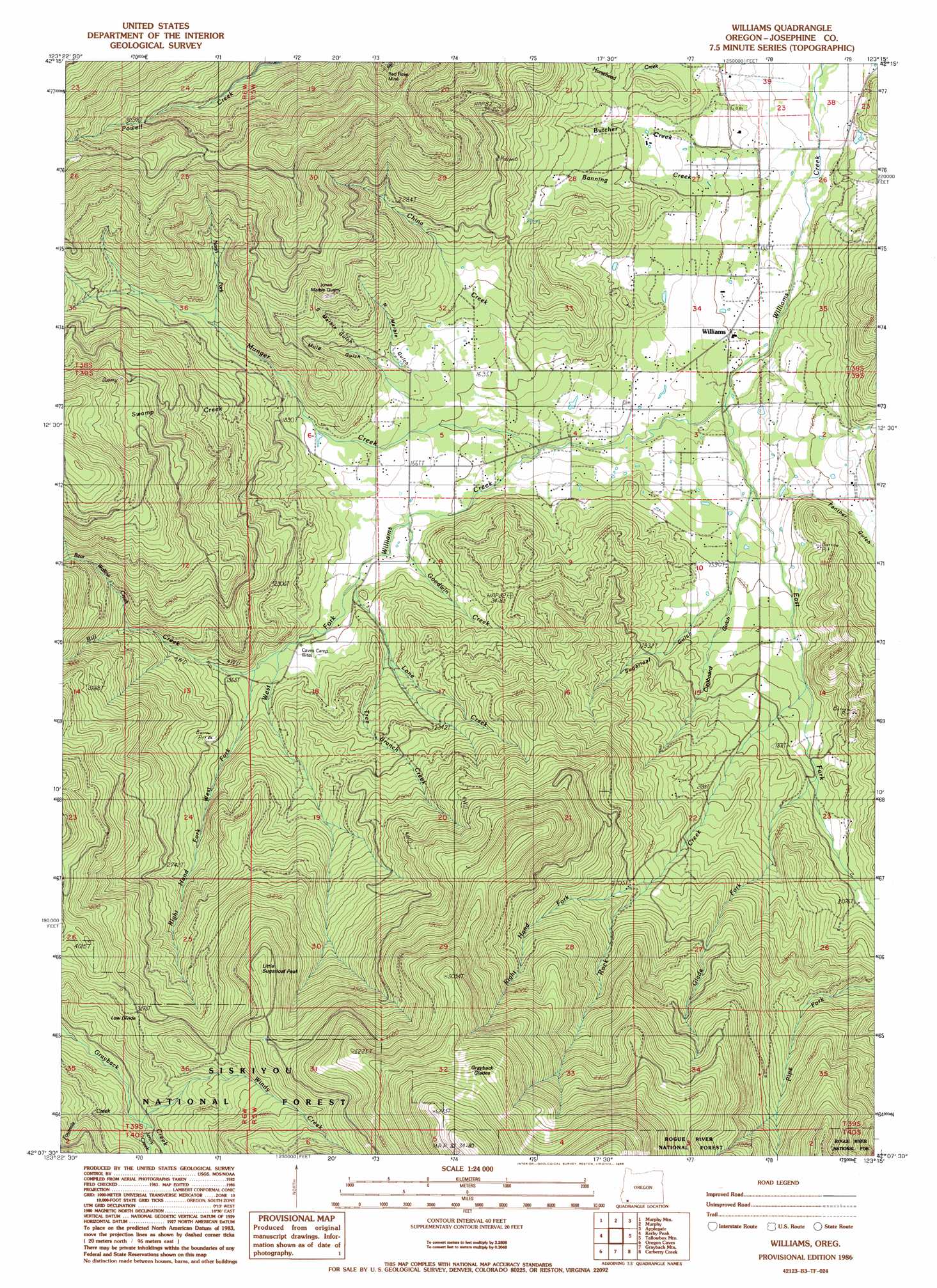
Williams Topo Map Oregon
To zoom in, hover over the map of Williams
USGS Topo Quad 42123b3 - 1:24,000 scale
| Topo Map Name: | Williams |
| USGS Topo Quad ID: | 42123b3 |
| Print Size: | ca. 21 1/4" wide x 27" high |
| Southeast Coordinates: | 42.125° N latitude / 123.25° W longitude |
| Map Center Coordinates: | 42.1875° N latitude / 123.3125° W longitude |
| U.S. State: | OR |
| Filename: | o42123b3.jpg |
| Download Map JPG Image: | Williams topo map 1:24,000 scale |
| Map Type: | Topographic |
| Topo Series: | 7.5´ |
| Map Scale: | 1:24,000 |
| Source of Map Images: | United States Geological Survey (USGS) |
| Alternate Map Versions: |
Williams OR 1986, updated 1986 Download PDF Buy paper map Williams OR 1996, updated 1999 Download PDF Buy paper map Williams OR 2011 Download PDF Buy paper map Williams OR 2014 Download PDF Buy paper map |
| FStopo: | US Forest Service topo Williams is available: Download FStopo PDF Download FStopo TIF |
1:24,000 Topo Quads surrounding Williams
Onion Mountain |
Wilderville |
Grants Pass |
Rogue River |
Gold Hill |
Selma |
Murphy Mountain |
Murphy |
Applegate |
Mount Isabelle |
Holland |
Kerby Peak |
Williams |
Tallowbox Mountain |
Ruch |
Takilma |
Oregon Caves |
Grayback Mountain |
Carberry Creek |
Squaw Lakes |
Polar Bear Mountain |
Deadman Point |
Figurehead Mountain |
Kangaroo Mountain |
Dutch Creek |
> Back to 42123a1 at 1:100,000 scale
> Back to 42122a1 at 1:250,000 scale
> Back to U.S. Topo Maps home
Williams topo map: Gazetteer
Williams: Canals
Baltimore Ditch elevation 456m 1496′Williams: Flats
Grayback Glades elevation 1694m 5557′Williams: Gaps
Low Divide elevation 1096m 3595′Williams: Mines
Bear Mine elevation 664m 2178′Bristol Quarry elevation 778m 2552′
Brown Owl Mine elevation 823m 2700′
Jones Marble Quarry elevation 798m 2618′
Red Rose Mine elevation 922m 3024′
Silver Tip Mine elevation 1097m 3599′
Watts Mine elevation 516m 1692′
Williams: Populated Places
Williams elevation 428m 1404′Williamsburg (historical) elevation 403m 1322′
Williams: Post Offices
Williams Post Office elevation 428m 1404′Williamsburg Post Office (historical) elevation 403m 1322′
Williams: Reservoirs
Brown Res elevation 563m 1847′Cedar Pond elevation 426m 1397′
Dunlop Reservoir elevation 536m 1758′
Ferber Reservoir elevation 502m 1646′
Graves Reservoir elevation 507m 1663′
Hartley Reservoir elevation 465m 1525′
Holzhauser Reservoir elevation 416m 1364′
Katzenbach Reservoir elevation 398m 1305′
Kings Reservoir elevation 420m 1377′
Miller Reservoir elevation 464m 1522′
Remey Reservoir elevation 459m 1505′
Trader Reservoir elevation 443m 1453′
Whittier Reservoir elevation 468m 1535′
Williams: Springs
Dugout Spring elevation 430m 1410′Williams: Streams
Banning Creek elevation 399m 1309′Bear Wallow Creek elevation 743m 2437′
Bill Creek elevation 604m 1981′
Blue Jay Creek elevation 408m 1338′
Butcher Creek elevation 416m 1364′
China Creek elevation 454m 1489′
East Fork Williams Creek elevation 434m 1423′
Fourmile Creek elevation 998m 3274′
Glade Fork elevation 570m 1870′
Goodwin Creek elevation 501m 1643′
Horsehead Creek elevation 439m 1440′
Horsetail Creek elevation 611m 2004′
Jenny Creek elevation 1009m 3310′
Lone Creek elevation 527m 1729′
Munger Creek elevation 462m 1515′
North Fork Munger Creek elevation 618m 2027′
Pipe Fork elevation 748m 2454′
Right Hand Fork Rock Creek elevation 773m 2536′
Right Hand Fork West Fork Williams Creek elevation 591m 1938′
Rock Creek elevation 523m 1715′
Swamp Creek elevation 551m 1807′
Tree Branch Creek elevation 612m 2007′
West Fork Williams Creek elevation 434m 1423′
Wildcat Creek elevation 534m 1751′
Windy Creek elevation 976m 3202′
Williams: Summits
Little Sugarloaf Peak elevation 1309m 4294′Williams: Trails
Grayback Clapboard Trail elevation 1797m 5895′Williams: Valleys
Bamboo Gulch elevation 405m 1328′Cherry Gulch elevation 512m 1679′
Clapboard Gulch elevation 484m 1587′
Davidson Gulch elevation 479m 1571′
Elder Gulch elevation 523m 1715′
Fiddlers Gulch elevation 510m 1673′
Maple Springs Gulch elevation 428m 1404′
Mule Gulch elevation 514m 1686′
North Marble Gulch elevation 504m 1653′
Panther Gulch elevation 477m 1564′
South Marble Gulch elevation 568m 1863′
Sugarloaf Gulch elevation 487m 1597′
Sunflower Gulch elevation 549m 1801′
Yew Wood Gulch elevation 471m 1545′
Williams digital topo map on disk
Buy this Williams topo map showing relief, roads, GPS coordinates and other geographical features, as a high-resolution digital map file on DVD: