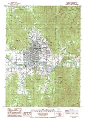
Grants Pass Topo Map Oregon
To zoom in, hover over the map of Grants Pass
USGS Topo Quad 42123d3 - 1:24,000 scale
| Topo Map Name: | Grants Pass |
| USGS Topo Quad ID: | 42123d3 |
| Print Size: | ca. 21 1/4" wide x 27" high |
| Southeast Coordinates: | 42.375° N latitude / 123.25° W longitude |
| Map Center Coordinates: | 42.4375° N latitude / 123.3125° W longitude |
| U.S. State: | OR |
| Filename: | o42123d3.jpg |
| Download Map JPG Image: | Grants Pass topo map 1:24,000 scale |
| Map Type: | Topographic |
| Topo Series: | 7.5´ |
| Map Scale: | 1:24,000 |
| Source of Map Images: | United States Geological Survey (USGS) |
| Alternate Map Versions: |
Grants Pass NE OR 1974, updated 1979 Download PDF Buy paper map Grants Pass NE OR 1974, updated 1979 Download PDF Buy paper map Grants Pass OR 1986, updated 1986 Download PDF Buy paper map Grants Pass OR 1996, updated 1999 Download PDF Buy paper map Grants Pass OR 2011 Download PDF Buy paper map Grants Pass OR 2014 Download PDF Buy paper map |
| FStopo: | US Forest Service topo Grants Pass is available: Download FStopo PDF Download FStopo TIF |
1:24,000 Topo Quads surrounding Grants Pass
> Back to 42123a1 at 1:100,000 scale
> Back to 42122a1 at 1:250,000 scale
> Back to U.S. Topo Maps home
Grants Pass topo map: Gazetteer
Grants Pass: Airports
Inland Helicopters Heliport elevation 359m 1177′Josephine Memorial Hospital Emergency Heliport elevation 308m 1010′
Roseburg Lumber Company Airstrip elevation 288m 944′
Grants Pass: Bridges
Caveman Bridge elevation 271m 889′Grants Pass: Canals
Highline Canal elevation 314m 1030′South Highline Canal elevation 319m 1046′
South Main Canal elevation 293m 961′
Tokay Canal elevation 338m 1108′
Grants Pass: Cliffs
Devils Slide elevation 329m 1079′Grants Pass: Mines
Columbia Mine elevation 637m 2089′Granite Hill Mine elevation 640m 2099′
Ida Mine elevation 675m 2214′
Jewett Mine elevation 664m 2178′
Redjacket Mine elevation 700m 2296′
Grants Pass: Parks
Cathedral Hills County Park elevation 407m 1335′Chinook County Park elevation 288m 944′
Croxton Pioneer Memorial Park elevation 308m 1010′
George H Eckstein Park elevation 287m 941′
Lawnridge Park elevation 304m 997′
Riverside Park elevation 280m 918′
Tom Pearce County Park elevation 429m 1407′
Tussing Park elevation 268m 879′
Westholm Park elevation 287m 941′
Grants Pass: Populated Places
Fruitdale elevation 283m 928′Grants Pass elevation 288m 944′
Grants Pass: Post Offices
Granite Hill Post Office (historical) elevation 613m 2011′Grants Pass Post Office elevation 310m 1017′
Grants Pass: Rapids
Winterbottom Riffle elevation 286m 938′Grants Pass: Reservoirs
Spaulding Reservoir elevation 290m 951′Grants Pass: Ridges
Luther Divide elevation 573m 1879′Grants Pass: Springs
Gaughan Spring elevation 403m 1322′Grants Pass: Streams
Allen Creek elevation 269m 882′Bloody Run Creek elevation 296m 971′
Carl Creek elevation 319m 1046′
East Fork Gilbert Creek elevation 360m 1181′
East Fork Jones Creek elevation 334m 1095′
East Gold Brook elevation 455m 1492′
Fruitdale Creek elevation 278m 912′
Gilbert Creek elevation 271m 889′
Greens Creek elevation 317m 1040′
Jewett Creek elevation 365m 1197′
Jones Creek elevation 284m 931′
North Fork Louse Creek elevation 600m 1968′
Owl Creek elevation 379m 1243′
Rock Creek elevation 417m 1368′
Skunk Creek elevation 282m 925′
Soldier Creek elevation 369m 1210′
South Fork Louse Creek elevation 609m 1998′
Walker Creek elevation 298m 977′
West Fork Gilbert Creek elevation 358m 1174′
West Fork Jones Creek elevation 334m 1095′
West Gold Brook elevation 438m 1437′
Grants Pass: Summits
Bald Mountain elevation 816m 2677′Beacon Hill elevation 635m 2083′
Dollar Mountain elevation 534m 1751′
Grants Pass Peak elevation 1161m 3809′
Pickett Mountain elevation 832m 2729′
Grants Pass: Valleys
Blue Gulch elevation 328m 1076′Hamlin Gulch elevation 332m 1089′
KirKirs Canyon elevation 395m 1295′
Rich Gulch elevation 295m 967′
Grants Pass digital topo map on disk
Buy this Grants Pass topo map showing relief, roads, GPS coordinates and other geographical features, as a high-resolution digital map file on DVD:


