Onion Mountain Topo Map Oregon
To zoom in, hover over the map of Onion Mountain
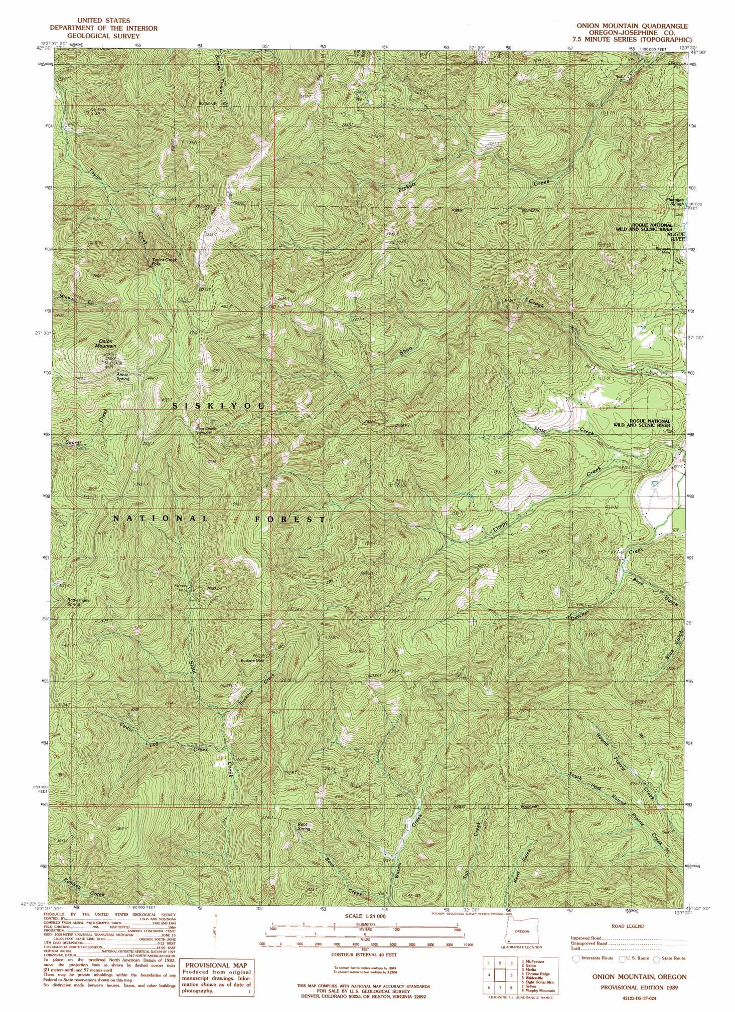
USGS Topo Quad 42123d5 - 1:24,000 scale
| Topo Map Name: | Onion Mountain |
| USGS Topo Quad ID: | 42123d5 |
| Print Size: | ca. 21 1/4" wide x 27" high |
| Southeast Coordinates: | 42.375° N latitude / 123.5° W longitude |
| Map Center Coordinates: | 42.4375° N latitude / 123.5625° W longitude |
| U.S. State: | OR |
| Filename: | o42123d5.jpg |
| Download Map JPG Image: | Onion Mountain topo map 1:24,000 scale |
| Map Type: | Topographic |
| Topo Series: | 7.5´ |
| Map Scale: | 1:24,000 |
| Source of Map Images: | United States Geological Survey (USGS) |
| Alternate Map Versions: |
Onion Mountain OR 1989, updated 1989 Download PDF Buy paper map Onion Mountain OR 1996, updated 1999 Download PDF Buy paper map Onion Mountain OR 2011 Download PDF Buy paper map Onion Mountain OR 2014 Download PDF Buy paper map |
| FStopo: | US Forest Service topo Onion Mountain is available: Download FStopo PDF Download FStopo TIF |
1:24,000 Topo Quads surrounding Onion Mountain
Kelsey Peak |
Bunker Creek |
Mount Reuben |
Glendale |
Golden |
Hobson Horn |
Mount Peavine |
Galice |
Merlin |
Sexton Mountain |
York Butte |
Chrome Ridge |
Onion Mountain |
Wilderville |
Grants Pass |
Pearsoll Peak |
Eight Dollar Mountain |
Selma |
Murphy Mountain |
Murphy |
Josephine Mountain |
Cave Junction |
Holland |
Kerby Peak |
Williams |
> Back to 42123a1 at 1:100,000 scale
> Back to 42122a1 at 1:250,000 scale
> Back to U.S. Topo Maps home
Onion Mountain topo map: Gazetteer
Onion Mountain: Airports
Wonder Airstrip (historical) elevation 629m 2063′Onion Mountain: Falls
Taylor Creek Falls elevation 994m 3261′Onion Mountain: Lakes
Flanagan Slough elevation 257m 843′Onion Mountain: Mines
Buckeye Mine elevation 822m 2696′Flanagan Mine elevation 251m 823′
Murry Mine elevation 1137m 3730′
Ramsey Mine elevation 760m 2493′
Onion Mountain: Post Offices
Trask Post Office (historical) elevation 1178m 3864′Onion Mountain: Springs
Annie Spring elevation 1256m 4120′Root Spring elevation 639m 2096′
Onion Mountain: Streams
Bear Creek elevation 391m 1282′Buckeye Creek elevation 641m 2103′
Cedar Log Creek elevation 577m 1893′
China Creek elevation 282m 925′
Dutcher Creek elevation 258m 846′
Limpy Creek elevation 254m 833′
Slate Creek elevation 289m 948′
Onion Mountain: Summits
Onion Mountain elevation 1306m 4284′Onion Mountain: Valleys
Blue Gulch elevation 336m 1102′Midnight Gulch elevation 369m 1210′
Panther Gulch elevation 298m 977′
Onion Mountain digital topo map on disk
Buy this Onion Mountain topo map showing relief, roads, GPS coordinates and other geographical features, as a high-resolution digital map file on DVD: