Chrome Ridge Topo Map Oregon
To zoom in, hover over the map of Chrome Ridge
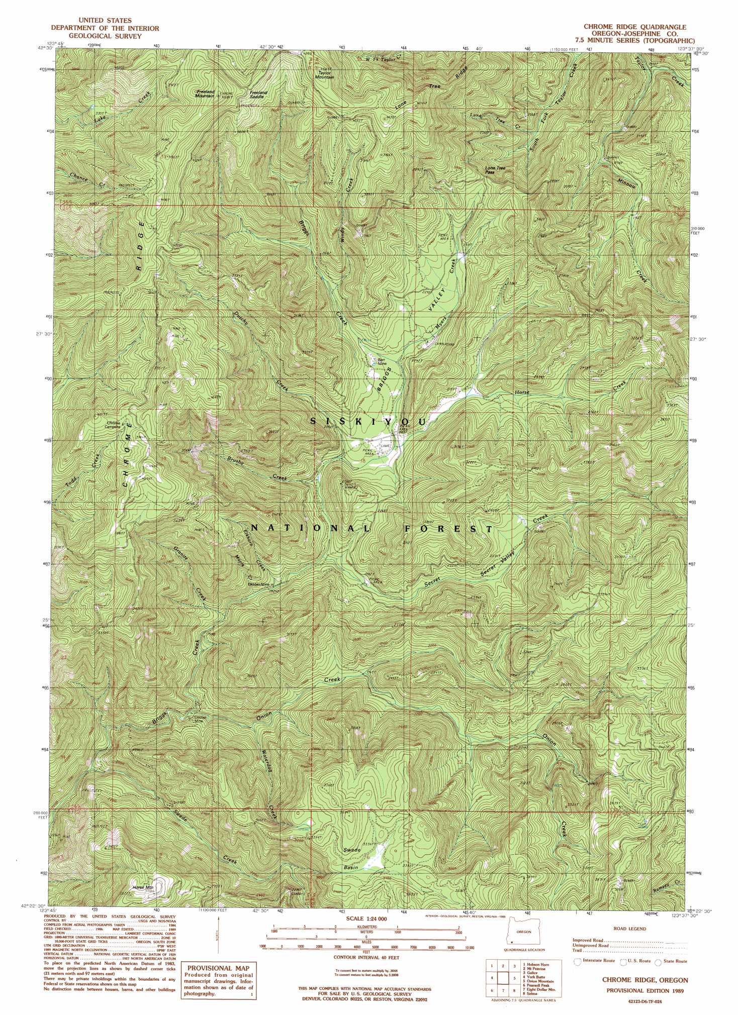
USGS Topo Quad 42123d6 - 1:24,000 scale
| Topo Map Name: | Chrome Ridge |
| USGS Topo Quad ID: | 42123d6 |
| Print Size: | ca. 21 1/4" wide x 27" high |
| Southeast Coordinates: | 42.375° N latitude / 123.625° W longitude |
| Map Center Coordinates: | 42.4375° N latitude / 123.6875° W longitude |
| U.S. State: | OR |
| Filename: | o42123d6.jpg |
| Download Map JPG Image: | Chrome Ridge topo map 1:24,000 scale |
| Map Type: | Topographic |
| Topo Series: | 7.5´ |
| Map Scale: | 1:24,000 |
| Source of Map Images: | United States Geological Survey (USGS) |
| Alternate Map Versions: |
Chrome Ridge OR 1989, updated 1989 Download PDF Buy paper map Chrome Ridge OR 1996, updated 1999 Download PDF Buy paper map Chrome Ridge OR 2011 Download PDF Buy paper map Chrome Ridge OR 2014 Download PDF Buy paper map |
| FStopo: | US Forest Service topo Chrome Ridge is available: Download FStopo PDF Download FStopo TIF |
1:24,000 Topo Quads surrounding Chrome Ridge
Marial |
Kelsey Peak |
Bunker Creek |
Mount Reuben |
Glendale |
Brandy Peak |
Hobson Horn |
Mount Peavine |
Galice |
Merlin |
Silver Peak |
York Butte |
Chrome Ridge |
Onion Mountain |
Wilderville |
Tincup Peak |
Pearsoll Peak |
Eight Dollar Mountain |
Selma |
Murphy Mountain |
Chetco Peak |
Josephine Mountain |
Cave Junction |
Holland |
Kerby Peak |
> Back to 42123a1 at 1:100,000 scale
> Back to 42122a1 at 1:250,000 scale
> Back to U.S. Topo Maps home
Chrome Ridge topo map: Gazetteer
Chrome Ridge: Basins
Swede Basin elevation 1035m 3395′Chrome Ridge: Gaps
Freeland Saddle elevation 1273m 4176′Lone Tree Pass elevation 784m 2572′
Chrome Ridge: Mines
Barr Mine elevation 660m 2165′Courier Mine elevation 525m 1722′
Elkhorn Mine elevation 601m 1971′
Chrome Ridge: Ridges
Chrome Ridge elevation 1135m 3723′Lone Tree Ridge elevation 1126m 3694′
Chrome Ridge: Springs
Rattlesnake Spring elevation 1107m 3631′Chrome Ridge: Streams
Brushy Creek elevation 597m 1958′Dutchy Creek elevation 605m 1984′
Elkhorn Creek elevation 593m 1945′
Granite Creek elevation 596m 1955′
Horse Creek elevation 591m 1938′
Lone Tree Creek elevation 552m 1811′
Maple Creek elevation 569m 1866′
Minnow Creek elevation 489m 1604′
Myers Creek elevation 648m 2125′
Onion Creek elevation 520m 1706′
Secret Creek elevation 587m 1925′
South Fork Taylor Creek elevation 481m 1578′
Swede Creek elevation 493m 1617′
Valley Creek elevation 665m 2181′
Waterdog Creek elevation 553m 1814′
Windy Creek elevation 712m 2335′
Chrome Ridge: Summits
Freeland Mountain elevation 1377m 4517′Horse Mountain elevation 1065m 3494′
Taylor Mountain elevation 1324m 4343′
Chrome Ridge: Valleys
Briggs Valley elevation 630m 2066′Secret Valley elevation 643m 2109′
Whiskey Gulch elevation 625m 2050′
Chrome Ridge digital topo map on disk
Buy this Chrome Ridge topo map showing relief, roads, GPS coordinates and other geographical features, as a high-resolution digital map file on DVD: