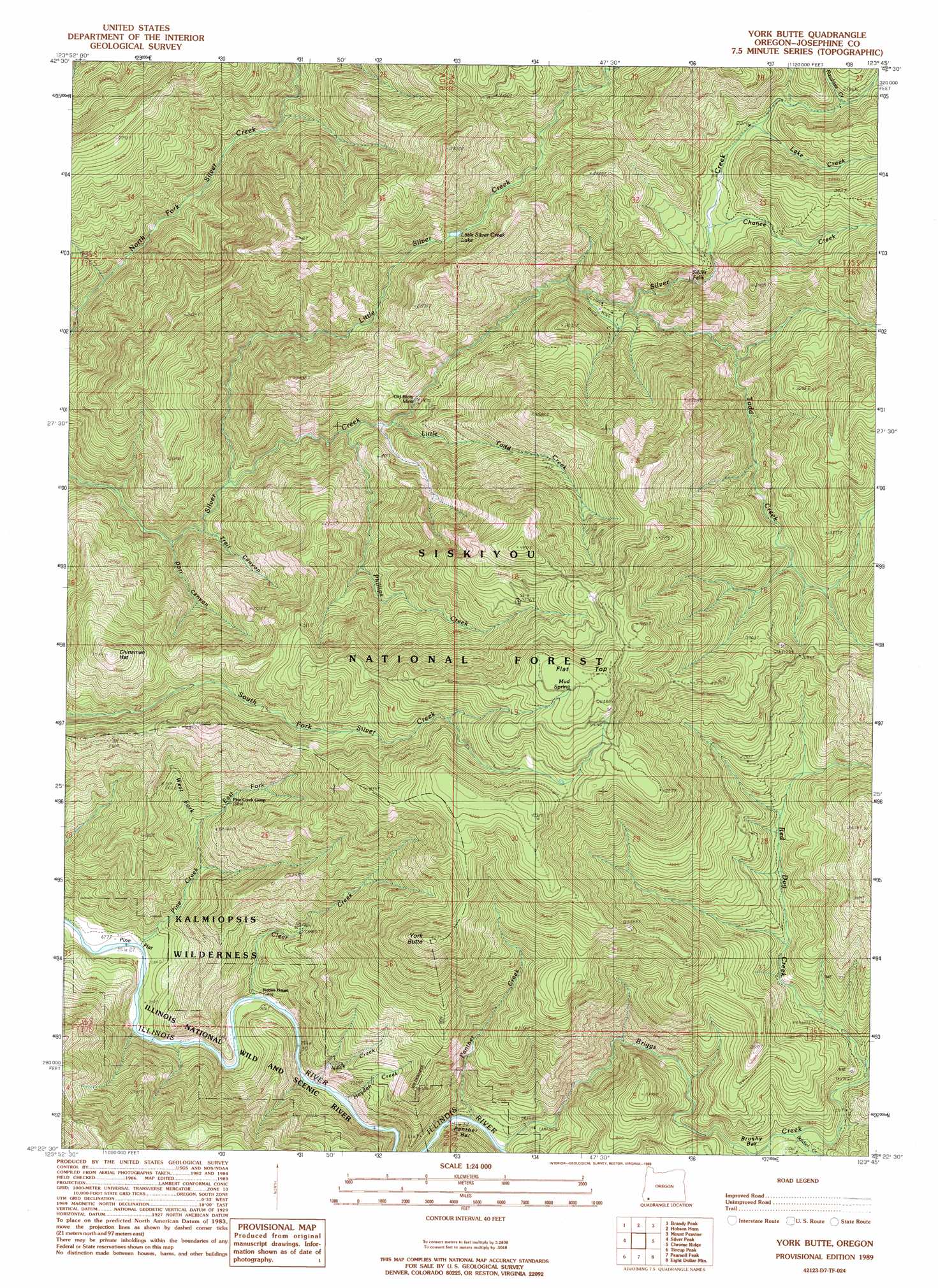
York Butte Topo Map Oregon
To zoom in, hover over the map of York Butte
USGS Topo Quad 42123d7 - 1:24,000 scale
| Topo Map Name: | York Butte |
| USGS Topo Quad ID: | 42123d7 |
| Print Size: | ca. 21 1/4" wide x 27" high |
| Southeast Coordinates: | 42.375° N latitude / 123.75° W longitude |
| Map Center Coordinates: | 42.4375° N latitude / 123.8125° W longitude |
| U.S. State: | OR |
| Filename: | o42123d7.jpg |
| Download Map JPG Image: | York Butte topo map 1:24,000 scale |
| Map Type: | Topographic |
| Topo Series: | 7.5´ |
| Map Scale: | 1:24,000 |
| Source of Map Images: | United States Geological Survey (USGS) |
| Alternate Map Versions: |
York Butte OR 1989, updated 1989 Download PDF Buy paper map York Butte OR 1998, updated 2001 Download PDF Buy paper map York Butte OR 2011 Download PDF Buy paper map York Butte OR 2014 Download PDF Buy paper map |
| FStopo: | US Forest Service topo York Butte is available: Download FStopo PDF Download FStopo TIF |
1:24,000 Topo Quads surrounding York Butte
Illahe |
Marial |
Kelsey Peak |
Bunker Creek |
Mount Reuben |
Agness |
Brandy Peak |
Hobson Horn |
Mount Peavine |
Galice |
Horse Sign Butte |
Silver Peak |
York Butte |
Chrome Ridge |
Onion Mountain |
Big Craggies |
Tincup Peak |
Pearsoll Peak |
Eight Dollar Mountain |
Selma |
Quail Prairie Mountain |
Chetco Peak |
Josephine Mountain |
Cave Junction |
Holland |
> Back to 42123a1 at 1:100,000 scale
> Back to 42122a1 at 1:250,000 scale
> Back to U.S. Topo Maps home
York Butte topo map: Gazetteer
York Butte: Areas
Dasher Meadow elevation 447m 1466′York Creek Botanical Area elevation 759m 2490′
York Butte: Bars
Brushy Bar elevation 461m 1512′Panther Bar elevation 307m 1007′
York Butte: Falls
Silver Falls elevation 537m 1761′York Butte: Flats
Pine Flat elevation 217m 711′York Butte: Lakes
Little Silver Creek Lake elevation 680m 2230′York Butte: Mines
Old Glory Mine elevation 428m 1404′York Butte: Parks
Nobles House elevation 240m 787′York Butte: Springs
Mud Springs elevation 1329m 4360′York Butte: Streams
Briggs Creek elevation 258m 846′Chance Creek elevation 678m 2224′
Clear Creek elevation 259m 849′
East Fork Pine Creek elevation 481m 1578′
Hayden Creek elevation 236m 774′
Lake Creek elevation 711m 2332′
Little Silver Creek elevation 404m 1325′
Little Todd Creek elevation 409m 1341′
Moon Creek elevation 416m 1364′
Panther Creek elevation 251m 823′
Phillips Creek elevation 396m 1299′
Pine Creek elevation 207m 679′
Rawhide Creek elevation 750m 2460′
Red Dog Creek elevation 462m 1515′
Soldier Creek elevation 448m 1469′
Todd Creek elevation 602m 1975′
West Fork Pine Creek elevation 469m 1538′
York Creek elevation 286m 938′
York Butte: Summits
Chinaman Hat elevation 990m 3248′Flat Top elevation 1377m 4517′
York Butte elevation 1286m 4219′
York Butte: Valleys
Dorr Canyon elevation 370m 1213′Trail Canyon elevation 334m 1095′
York Butte digital topo map on disk
Buy this York Butte topo map showing relief, roads, GPS coordinates and other geographical features, as a high-resolution digital map file on DVD: