Wimer Topo Map Oregon
To zoom in, hover over the map of Wimer
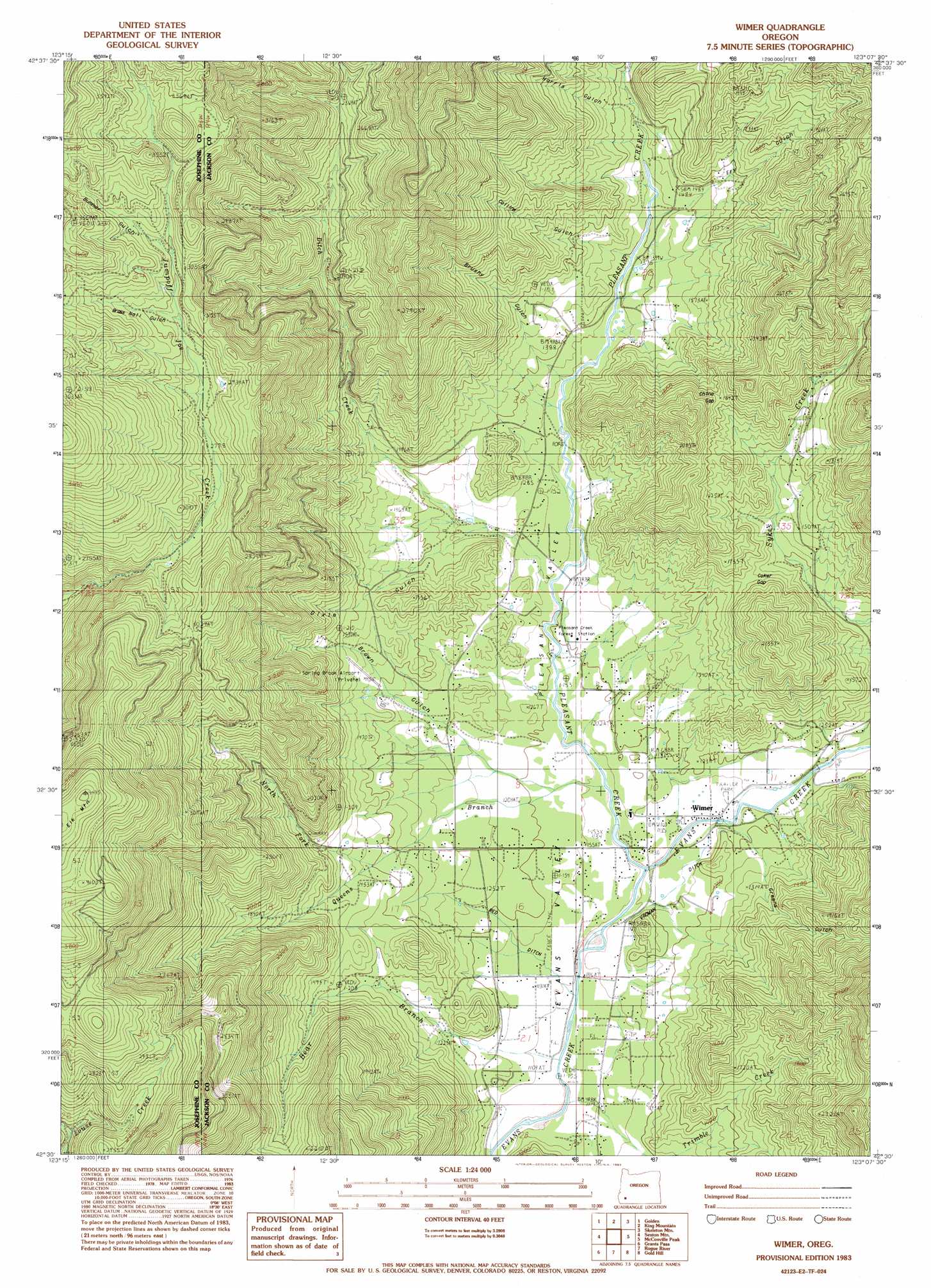
USGS Topo Quad 42123e2 - 1:24,000 scale
| Topo Map Name: | Wimer |
| USGS Topo Quad ID: | 42123e2 |
| Print Size: | ca. 21 1/4" wide x 27" high |
| Southeast Coordinates: | 42.5° N latitude / 123.125° W longitude |
| Map Center Coordinates: | 42.5625° N latitude / 123.1875° W longitude |
| U.S. State: | OR |
| Filename: | o42123e2.jpg |
| Download Map JPG Image: | Wimer topo map 1:24,000 scale |
| Map Type: | Topographic |
| Topo Series: | 7.5´ |
| Map Scale: | 1:24,000 |
| Source of Map Images: | United States Geological Survey (USGS) |
| Alternate Map Versions: |
Wimer OR 1983, updated 1983 Download PDF Buy paper map Wimer OR 1996, updated 1999 Download PDF Buy paper map Wimer OR 2011 Download PDF Buy paper map Wimer OR 2014 Download PDF Buy paper map |
| FStopo: | US Forest Service topo Wimer is available: Download FStopo PDF Download FStopo TIF |
1:24,000 Topo Quads surrounding Wimer
Mccullough Creek |
Quines Creek |
Starvout Creek |
Cedar Springs Mountain |
Richter Mountain |
Glendale |
Golden |
King Mountain |
Skeleton Mountain |
Cleveland Ridge |
Merlin |
Sexton Mountain |
Wimer |
Mcconville Peak |
Boswell Mountain |
Wilderville |
Grants Pass |
Rogue River |
Gold Hill |
Sams Valley |
Murphy Mountain |
Murphy |
Applegate |
Mount Isabelle |
Medford West |
> Back to 42123e1 at 1:100,000 scale
> Back to 42122a1 at 1:250,000 scale
> Back to U.S. Topo Maps home
Wimer topo map: Gazetteer
Wimer: Airports
Spring Brook Airstrip elevation 453m 1486′Wimer: Canals
Red Ditch elevation 333m 1092′Vroman Ditch elevation 350m 1148′
Williams and Whalen Ditch elevation 368m 1207′
Wimer: Gaps
China Gap elevation 570m 1870′Coker Gap elevation 473m 1551′
Wimer: Mines
Penny Ante Mine elevation 624m 2047′Wimer: Populated Places
Wimer elevation 343m 1125′Wimer: Post Offices
Wimer Post Office (historical) elevation 343m 1125′Wimer: Reservoirs
Badcock Reservoir elevation 350m 1148′Jackson Reservoir elevation 462m 1515′
Standard Basin Reservoir elevation 436m 1430′
Zwan Reservoir elevation 407m 1335′
Wimer: Streams
Bear Branch elevation 333m 1092′Ditch Creek elevation 378m 1240′
Ladies Creek elevation 406m 1332′
North Fork Queens Branch elevation 428m 1404′
Pleasant Creek elevation 341m 1118′
Potter Creek elevation 367m 1204′
Queens Branch elevation 350m 1148′
Saddle Creek elevation 343m 1125′
Wimer: Summits
Elk Mountain elevation 1342m 4402′Wimer: Valleys
A K Gulch elevation 468m 1535′Brass Nail Gulch elevation 891m 2923′
Brown Gulch elevation 368m 1207′
Brushy Gulch elevation 420m 1377′
Bummer Gulch elevation 910m 2985′
Collins Gulch elevation 422m 1384′
Dixie Gulch elevation 408m 1338′
Evans Gulch elevation 445m 1459′
Evans Valley elevation 327m 1072′
French Gulch elevation 481m 1578′
Fry Gulch elevation 435m 1427′
Greens Gulch elevation 368m 1207′
Harris Gulch elevation 470m 1541′
Pleasant Valley elevation 348m 1141′
Rocky Gulch elevation 534m 1751′
Wimer digital topo map on disk
Buy this Wimer topo map showing relief, roads, GPS coordinates and other geographical features, as a high-resolution digital map file on DVD: