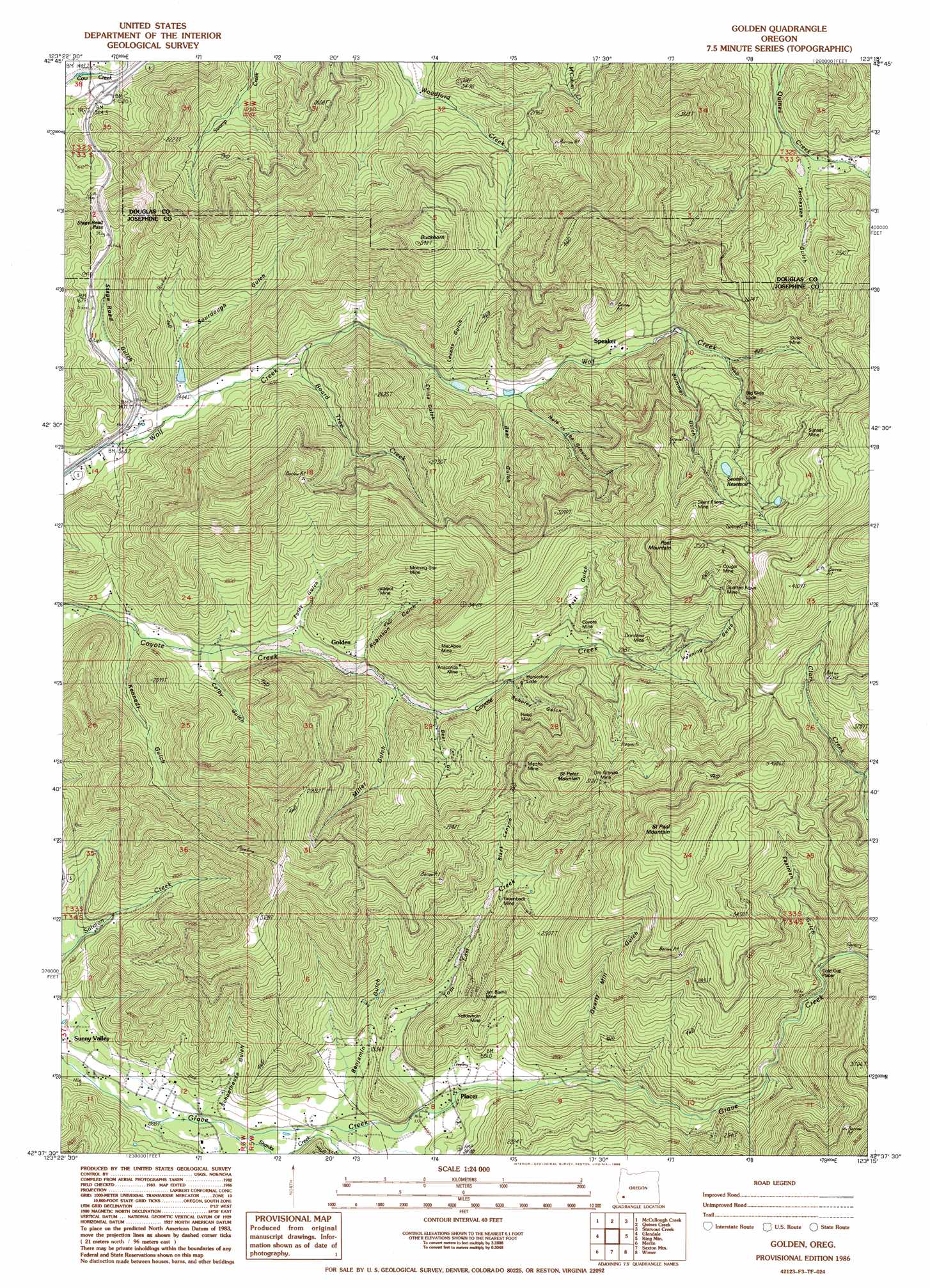
Golden Topo Map Oregon
To zoom in, hover over the map of Golden
USGS Topo Quad 42123f3 - 1:24,000 scale
| Topo Map Name: | Golden |
| USGS Topo Quad ID: | 42123f3 |
| Print Size: | ca. 21 1/4" wide x 27" high |
| Southeast Coordinates: | 42.625° N latitude / 123.25° W longitude |
| Map Center Coordinates: | 42.6875° N latitude / 123.3125° W longitude |
| U.S. State: | OR |
| Filename: | o42123f3.jpg |
| Download Map JPG Image: | Golden topo map 1:24,000 scale |
| Map Type: | Topographic |
| Topo Series: | 7.5´ |
| Map Scale: | 1:24,000 |
| Source of Map Images: | United States Geological Survey (USGS) |
| Alternate Map Versions: |
Golden OR 1986, updated 1986 Download PDF Buy paper map Golden OR 1996, updated 1999 Download PDF Buy paper map Golden OR 2011 Download PDF Buy paper map Golden OR 2014 Download PDF Buy paper map |
| FStopo: | US Forest Service topo Golden is available: Download FStopo PDF Download FStopo TIF |
1:24,000 Topo Quads surrounding Golden
Live Oak Mountain |
Nickel Mountain |
Canyonville |
Days Creek |
Milo |
Rabbit Mountain |
Mccullough Creek |
Quines Creek |
Starvout Creek |
Cedar Springs Mountain |
Mount Reuben |
Glendale |
Golden |
King Mountain |
Skeleton Mountain |
Galice |
Merlin |
Sexton Mountain |
Wimer |
Mcconville Peak |
Onion Mountain |
Wilderville |
Grants Pass |
Rogue River |
Gold Hill |
> Back to 42123e1 at 1:100,000 scale
> Back to 42122a1 at 1:250,000 scale
> Back to U.S. Topo Maps home
Golden topo map: Gazetteer
Golden: Dams
Strong Dam elevation 485m 1591′Golden: Gaps
Stage Road Pass elevation 553m 1814′Golden: Mines
Anaconda Mine elevation 661m 2168′Big Slide Lode elevation 714m 2342′
Blue Channel Placer elevation 459m 1505′
Columbia Placer elevation 512m 1679′
Cougar Mine elevation 970m 3182′
Coyote Mine elevation 651m 2135′
Dorothea Mine elevation 752m 2467′
Fandora Mine elevation 783m 2568′
Florene Mine elevation 673m 2208′
Gold Cup Placer elevation 677m 2221′
Golden Ring Mine elevation 1002m 3287′
Greenback Mine elevation 661m 2168′
Horseshoe Lode elevation 612m 2007′
Jackpot Mine elevation 628m 2060′
Jim Blaine Mine elevation 627m 2057′
MacAbee Mine elevation 747m 2450′
Martha Mine elevation 780m 2559′
Morning Mine elevation 676m 2217′
Oro Grande Mine elevation 947m 3106′
Payne Placer elevation 462m 1515′
Reed Mine elevation 687m 2253′
Shot Mine elevation 874m 2867′
Silent Friend Mine elevation 996m 3267′
Sluter Mine elevation 719m 2358′
Speaker Placer elevation 527m 1729′
Spotted Fawn Mine elevation 942m 3090′
Star Mine elevation 458m 1502′
Sunset Mine elevation 951m 3120′
Victor Mine elevation 535m 1755′
Yellowhorn Mine elevation 531m 1742′
Golden: Parks
Stage Coach Forest State Park elevation 553m 1814′Golden: Populated Places
Golden elevation 499m 1637′Greenback (historical) elevation 582m 1909′
Placer elevation 438m 1437′
Speaker elevation 597m 1958′
Golden: Post Offices
Golden Post Office (historical) elevation 499m 1637′Greenback Post Office (historical) elevation 582m 1909′
Placer Post Office (historical) elevation 438m 1437′
Speaker Post Office (historical) elevation 597m 1958′
Golden: Reservoirs
Lehman Reservoir elevation 691m 2267′Secesh Reservoir elevation 871m 2857′
Strong Reservoir elevation 453m 1486′
Golden: Springs
Big Spring elevation 512m 1679′Browning Spring elevation 503m 1650′
Cougar Spring elevation 1032m 3385′
Mountain Spring elevation 535m 1755′
Mountain Spring elevation 577m 1893′
Poe Spring elevation 525m 1722′
Golden: Streams
Board Tree Creek elevation 458m 1502′McCourtney Creek elevation 561m 1840′
Shanks Creek elevation 393m 1289′
Slagle Creek elevation 441m 1446′
Still Creek elevation 382m 1253′
Tom East Creek elevation 427m 1400′
Whiskey Bottle Creek elevation 561m 1840′
Golden: Summits
Buckhorn elevation 1029m 3375′Post Mountain elevation 1147m 3763′
Saint Paul Mountain elevation 1299m 4261′
Saint Peter Mountain elevation 1076m 3530′
Golden: Trails
King Mountain Truck Trail elevation 1066m 3497′Golden: Valleys
Bear Gulch elevation 518m 1699′Bear Gulch elevation 543m 1781′
Benjamin Gulch elevation 419m 1374′
Benson Gulch elevation 608m 1994′
Black Canyon elevation 617m 2024′
Brown Gulch elevation 518m 1699′
Bummer Gulch elevation 634m 2080′
China Gulch elevation 523m 1715′
Colby Gulch elevation 447m 1466′
Eastman Gulch elevation 691m 2267′
Foley Gulch elevation 473m 1551′
Grandpa Gulch elevation 560m 1837′
Hole in the Ground elevation 552m 1811′
Kennedy Gulch elevation 435m 1427′
Levens Gulch elevation 537m 1761′
Miller Gulch elevation 504m 1653′
Panning Gulch elevation 696m 2283′
Post Gulch elevation 620m 2034′
Quartz Mill Gulch elevation 538m 1765′
Robinson Gulch elevation 505m 1656′
Scholey Gulch elevation 587m 1925′
Schoolhouse Gulch elevation 407m 1335′
Secesh Gulch elevation 699m 2293′
Sourdough Gulch elevation 457m 1499′
Stage Road Gulch elevation 444m 1456′
Tennessee Gulch elevation 592m 1942′
Golden digital topo map on disk
Buy this Golden topo map showing relief, roads, GPS coordinates and other geographical features, as a high-resolution digital map file on DVD: