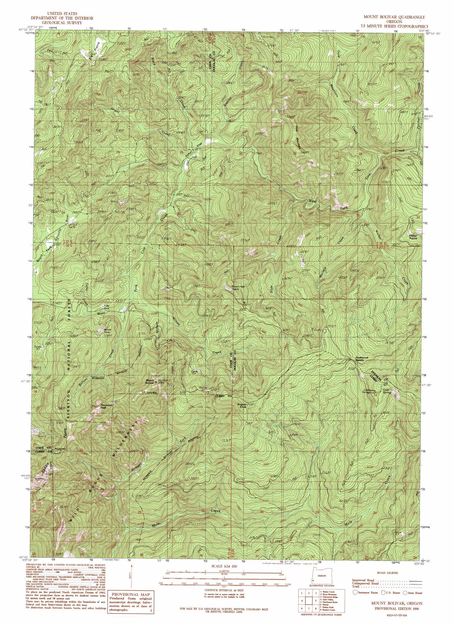
Mount Bolivar Topo Map Oregon
To zoom in, hover over the map of Mount Bolivar
USGS Topo Quad 42123g7 - 1:24,000 scale
| Topo Map Name: | Mount Bolivar |
| USGS Topo Quad ID: | 42123g7 |
| Print Size: | ca. 21 1/4" wide x 27" high |
| Southeast Coordinates: | 42.75° N latitude / 123.75° W longitude |
| Map Center Coordinates: | 42.8125° N latitude / 123.8125° W longitude |
| U.S. State: | OR |
| Filename: | o42123g7.jpg |
| Download Map JPG Image: | Mount Bolivar topo map 1:24,000 scale |
| Map Type: | Topographic |
| Topo Series: | 7.5´ |
| Map Scale: | 1:24,000 |
| Source of Map Images: | United States Geological Survey (USGS) |
| Alternate Map Versions: |
Mount Bolivar OR 1990, updated 1990 Download PDF Buy paper map Mount Bolivar OR 1998, updated 2001 Download PDF Buy paper map Mount Bolivar OR 2011 Download PDF Buy paper map Mount Bolivar OR 2014 Download PDF Buy paper map |
| FStopo: | US Forest Service topo Mount Bolivar is available: Download FStopo PDF Download FStopo TIF |
1:24,000 Topo Quads surrounding Mount Bolivar
Bridge |
Remote |
Kenyon Mountain |
Camas Valley |
Tenmile |
Powers |
Rasler Creek |
Bone Mountain |
Chipmunk Ridge |
Live Oak Mountain |
China Flat |
Eden Ridge Valley |
Mount Bolivar |
Dutchman Butte |
Rabbit Mountain |
Illahe |
Marial |
Kelsey Peak |
Bunker Creek |
Mount Reuben |
Agness |
Brandy Peak |
Hobson Horn |
Mount Peavine |
Galice |
> Back to 42123e1 at 1:100,000 scale
> Back to 42122a1 at 1:250,000 scale
> Back to U.S. Topo Maps home
Mount Bolivar topo map: Gazetteer
Mount Bolivar: Flats
Ashur Flat elevation 613m 2011′Big Prairie elevation 1069m 3507′
Mount Bolivar: Gaps
Anaktuvuk Saddle elevation 1006m 3300′Mount Bolivar: Mines
Bolivar Mine elevation 835m 2739′Fuller Mine elevation 645m 2116′
Mount Bolivar: Springs
Bolivar Spring elevation 923m 3028′Cold Spring elevation 1130m 3707′
Porphyry Spring elevation 921m 3021′
Mount Bolivar: Streams
Arrastra Fork Mule Creek elevation 546m 1791′Bear Creek elevation 586m 1922′
Black Creek elevation 572m 1876′
Bolivar Creek elevation 640m 2099′
East Fork of West Fork Cow Creek elevation 1067m 3500′
Fuller Creek elevation 658m 2158′
Gold Mountain Creek elevation 485m 1591′
Grant Creek elevation 570m 1870′
Lipp Creek elevation 625m 2050′
Mule Creek elevation 327m 1072′
Panther Creek elevation 461m 1512′
Slide Creek elevation 527m 1729′
Stanley Creek elevation 556m 1824′
Walker Creek elevation 487m 1597′
Wallace Creek elevation 505m 1656′
Wilson Creek elevation 618m 2027′
Mount Bolivar: Summits
August Knob elevation 1173m 3848′Diamond Peak elevation 1192m 3910′
Gold Mountain elevation 992m 3254′
Mount Bolivar elevation 1299m 4261′
Saddle Peaks elevation 1005m 3297′
Mount Bolivar digital topo map on disk
Buy this Mount Bolivar topo map showing relief, roads, GPS coordinates and other geographical features, as a high-resolution digital map file on DVD: