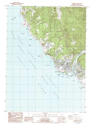
Brookings Topo Map Oregon
To zoom in, hover over the map of Brookings
USGS Topo Quad 42124a3 - 1:24,000 scale
| Topo Map Name: | Brookings |
| USGS Topo Quad ID: | 42124a3 |
| Print Size: | ca. 21 1/4" wide x 27" high |
| Southeast Coordinates: | 42° N latitude / 124.25° W longitude |
| Map Center Coordinates: | 42.0625° N latitude / 124.3125° W longitude |
| U.S. State: | OR |
| Filename: | o42124a3.jpg |
| Download Map JPG Image: | Brookings topo map 1:24,000 scale |
| Map Type: | Topographic |
| Topo Series: | 7.5´ |
| Map Scale: | 1:24,000 |
| Source of Map Images: | United States Geological Survey (USGS) |
| Alternate Map Versions: |
Brookings OR 1986, updated 1986 Download PDF Buy paper map Brookings OR 2011 Download PDF Buy paper map Brookings OR 2014 Download PDF Buy paper map |
| FStopo: | US Forest Service topo Brookings is available: Download FStopo PDF Download FStopo TIF |
1:24,000 Topo Quads surrounding Brookings
> Back to 42124a1 at 1:100,000 scale
> Back to 42124a1 at 1:250,000 scale
> Back to U.S. Topo Maps home
Brookings topo map: Gazetteer
Brookings: Airports
Brookings State Airport elevation 140m 459′Garvins Airfield elevation 89m 291′
Brookings: Bays
Chetco Cove elevation 0m 0′Macklyn Cove elevation 0m 0′
Brookings: Beaches
Harris Beach elevation 8m 26′Lone Ranch Beach elevation 1m 3′
Brookings: Capes
Cape Ferrelo elevation 0m 0′Chetco Point elevation 12m 39′
Tanbark Point elevation 0m 0′
Brookings: Channels
Morrison Hole elevation 9m 29′Brookings: Cliffs
Black Point elevation 41m 134′Rainbow Rock elevation 34m 111′
Red Point elevation 21m 68′
Brookings: Dams
Brookings Log Pond Dam elevation 31m 101′Ferry Creek Dam elevation 111m 364′
Brookings: Flats
Gray Flat elevation 71m 232′Brookings: Harbors
Port of Brookings elevation 0m 0′Brookings: Islands
Arch Rock elevation 0m 0′Barnacle Rock elevation 0m 0′
Bell Rock elevation 3m 9′
Brothers elevation 0m 0′
Brown Rock elevation 0m 0′
Cluster elevation 0m 0′
Couplets elevation 0m 0′
Cousins elevation 0m 0′
Diver Rock elevation 4m 13′
Fountain Rock elevation 0m 0′
Goat Island elevation 37m 121′
Green Rock elevation 5m 16′
Guano Rock elevation 0m 0′
Gull Rocks elevation 0m 0′
House Rock elevation 0m 0′
Hump Rock elevation 0m 0′
Lone Rock elevation 0m 0′
Long Rock elevation 0m 0′
Mussel Rock elevation 0m 0′
Pelican Rock elevation 0m 0′
Rainbow Island elevation 0m 0′
Red Rock elevation 15m 49′
Sisters elevation 0m 0′
Square Rock elevation 0m 0′
Square Rock elevation 0m 0′
Table Rock elevation 9m 29′
Twin Rocks elevation 0m 0′
Twons elevation 0m 0′
Walrus Rocks elevation 0m 0′
White Rock elevation 0m 0′
White Rock elevation 0m 0′
Yellow Rock elevation 0m 0′
Yellow Rock elevation 1m 3′
Zwagg Island elevation 24m 78′
Brookings: Parks
Azalea City Park elevation 67m 219′Bankus Fountain elevation 46m 150′
Bud Cross Park elevation 70m 229′
Chetco Point Park elevation 12m 39′
Easy Manor Park elevation 60m 196′
Harris Beach State Park elevation 45m 147′
Richards Street Park elevation 61m 200′
Samuel H Boardman State Park elevation 40m 131′
Stout Park elevation 54m 177′
Brookings: Populated Places
Brookings elevation 48m 157′Harbor elevation 10m 32′
Brookings: Post Offices
Brookings Post Office elevation 48m 157′Fern Post Office (historical) elevation 28m 91′
Ferry Post Office (historical) elevation 8m 26′
Gray Post Office (historical) elevation 110m 360′
Harbor Post Office elevation 10m 32′
Brookings: Reservoirs
Oregon Coast Log Pond elevation 70m 229′South Coast Log Pond elevation 69m 226′
Brookings: Streams
Bishop Creek elevation 39m 127′Bravo Creek elevation 64m 209′
Chetco River elevation 0m 0′
Duley Creek elevation 36m 118′
Eiler Creek elevation 15m 49′
Ferry Creek elevation 0m 0′
Foster Creek elevation 2m 6′
Grant Creek elevation 6m 19′
Harris Creek elevation 3m 9′
House Rock Creek elevation 50m 164′
Joe Hall Creek elevation 8m 26′
Lone Ranch Creek elevation 14m 45′
Macklyn Creek elevation 10m 32′
Mayfield Creek elevation 54m 177′
Ram Creek elevation 7m 22′
Ransom Creek elevation 9m 29′
Shy Creek elevation 4m 13′
Stack Creek elevation 14m 45′
Taylor Creek elevation 16m 52′
Tuttle Creek elevation 3m 9′
Brookings: Summits
Black Mound elevation 469m 1538′Harris Butte elevation 18m 59′
Red Mound elevation 495m 1624′
Sand Hill elevation 148m 485′
Brookings digital topo map on disk
Buy this Brookings topo map showing relief, roads, GPS coordinates and other geographical features, as a high-resolution digital map file on DVD:


