Barklow Mountain Topo Map Oregon
To zoom in, hover over the map of Barklow Mountain
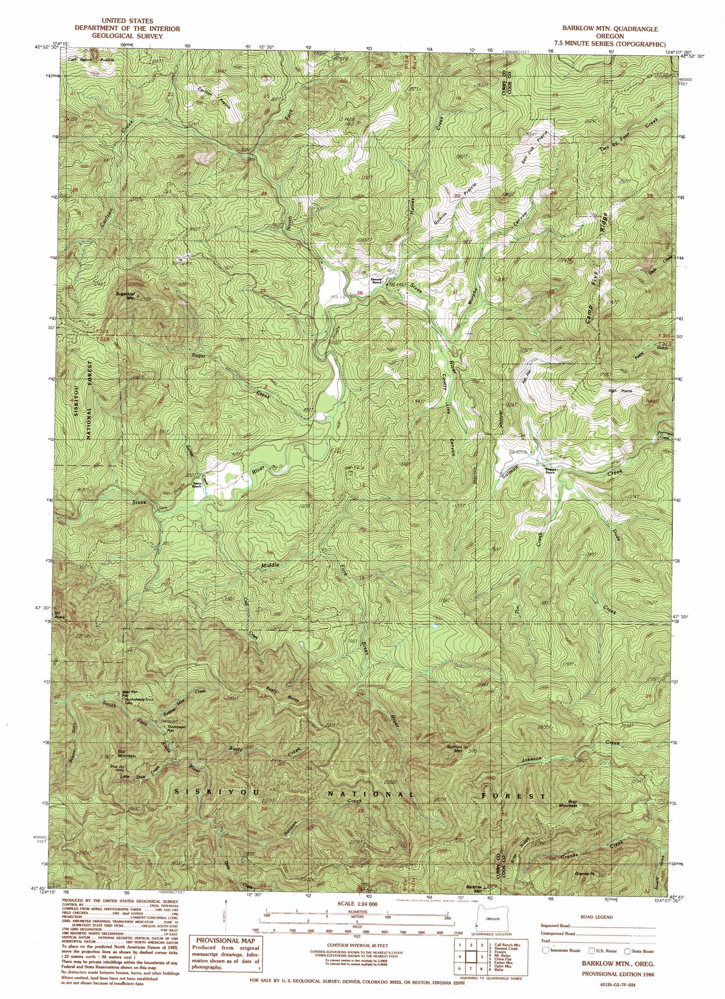
USGS Topo Quad 42124g2 - 1:24,000 scale
| Topo Map Name: | Barklow Mountain |
| USGS Topo Quad ID: | 42124g2 |
| Print Size: | ca. 21 1/4" wide x 27" high |
| Southeast Coordinates: | 42.75° N latitude / 124.125° W longitude |
| Map Center Coordinates: | 42.8125° N latitude / 124.1875° W longitude |
| U.S. State: | OR |
| Filename: | o42124g2.jpg |
| Download Map JPG Image: | Barklow Mountain topo map 1:24,000 scale |
| Map Type: | Topographic |
| Topo Series: | 7.5´ |
| Map Scale: | 1:24,000 |
| Source of Map Images: | United States Geological Survey (USGS) |
| Alternate Map Versions: |
Barklow Mountain OR 1986, updated 1986 Download PDF Buy paper map Barklow Mountain OR 1996, updated 1999 Download PDF Buy paper map Barklow Mountain OR 2011 Download PDF Buy paper map Barklow Mountain OR 2014 Download PDF Buy paper map |
| FStopo: | US Forest Service topo Barklow Mountain is available: Download FStopo PDF Download FStopo TIF |
1:24,000 Topo Quads surrounding Barklow Mountain
Bandon |
Bill Peak |
Myrtle Point |
Bridge |
Remote |
Langlois |
Calf Ranch Mountain |
Dement Creek |
Powers |
Rasler Creek |
Sixes |
Mount Butler |
Barklow Mountain |
China Flat |
Eden Ridge Valley |
Port Orford |
Father Mountain |
Ophir Mountain |
Illahe |
Marial |
Ophir |
Brushy Bald Mountain |
Soldier Camp Mountain |
Agness |
Brandy Peak |
> Back to 42124e1 at 1:100,000 scale
> Back to 42124a1 at 1:250,000 scale
> Back to U.S. Topo Maps home
Barklow Mountain topo map: Gazetteer
Barklow Mountain: Areas
Carlton Prairie elevation 298m 977′Guerin Prairie elevation 302m 990′
High Prairie elevation 503m 1650′
Barklow Mountain: Flats
Ash Flat elevation 294m 964′Bear Pan Flat elevation 237m 777′
Salt Lick Prairie elevation 470m 1541′
Thompson Flat elevation 273m 895′
Barklow Mountain: Mines
Blue Jay Mine elevation 553m 1814′Barklow Mountain: Populated Places
Eckley (historical) elevation 147m 482′Barklow Mountain: Post Offices
Eckley Post Office (historical) elevation 147m 482′Barklow Mountain: Ridges
Bray Ridge elevation 878m 2880′Camp Five Ridge elevation 561m 1840′
Barklow Mountain: Streams
Benson Creek elevation 319m 1046′Carlton Creek elevation 153m 501′
Cold Creek elevation 127m 416′
Dixie Creek elevation 382m 1253′
Dude Creek elevation 224m 734′
Flannigan Creek elevation 225m 738′
Florence Creek elevation 615m 2017′
Granite Creek elevation 451m 1479′
Haines Creek elevation 137m 449′
Hays Creek elevation 130m 426′
Josh Creek elevation 323m 1059′
Little Dixie Creek elevation 264m 866′
Middle Fork Sixes River elevation 102m 334′
North Fork Sixes River elevation 128m 419′
Riggs Creek elevation 193m 633′
Russian Mike Creek elevation 222m 728′
Rusty Creek elevation 266m 872′
Salmon Creek elevation 327m 1072′
Sucker Creek elevation 116m 380′
Sugar Creek elevation 114m 374′
Tim Creek elevation 218m 715′
Barklow Mountain: Summits
Barklow Mountain elevation 1085m 3559′Bray Mountain elevation 991m 3251′
Granite Peak elevation 965m 3166′
Rusty Butte elevation 731m 2398′
Salmon Mountain elevation 961m 3152′
Star Mountain elevation 602m 1975′
Sugarloaf Mountain elevation 732m 2401′
Barklow Mountain: Valleys
Butcher Gulch elevation 230m 754′County Line Canyon elevation 162m 531′
Murphy Canyon elevation 232m 761′
Barklow Mountain digital topo map on disk
Buy this Barklow Mountain topo map showing relief, roads, GPS coordinates and other geographical features, as a high-resolution digital map file on DVD: