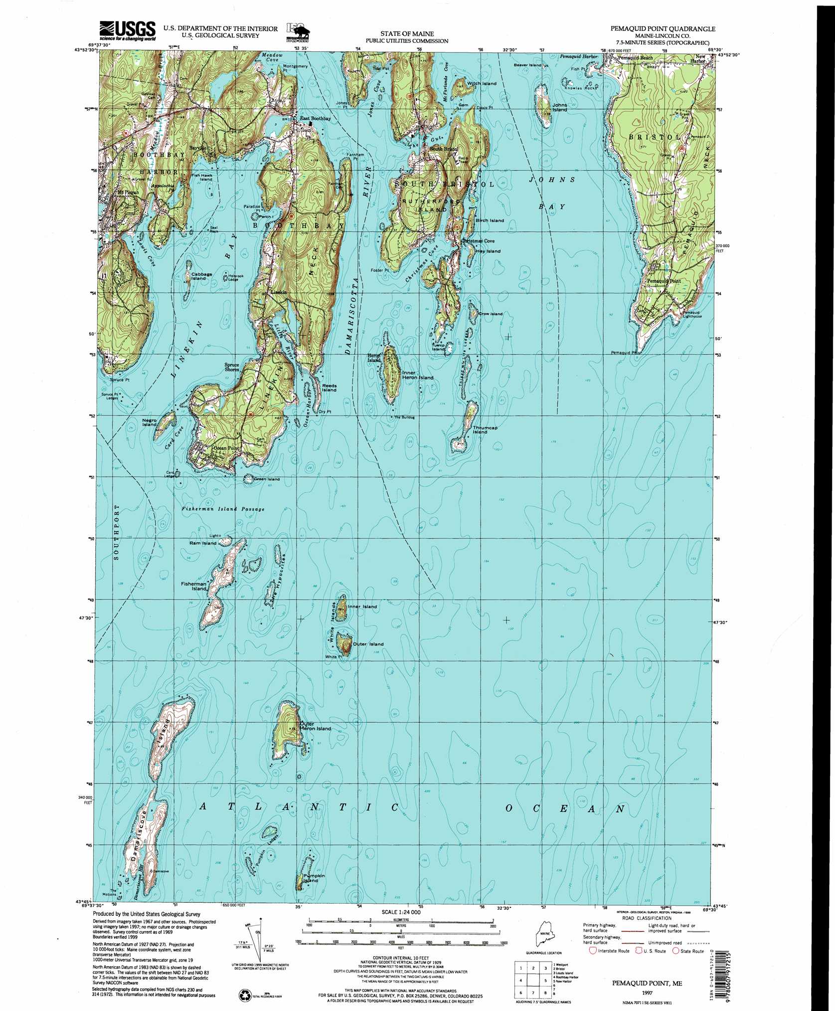
Pemaquid Point Topo Map Maine
To zoom in, hover over the map of Pemaquid Point
USGS Topo Quad 43069g5 - 1:24,000 scale
| Topo Map Name: | Pemaquid Point |
| USGS Topo Quad ID: | 43069g5 |
| Print Size: | ca. 21 1/4" wide x 27" high |
| Southeast Coordinates: | 43.75° N latitude / 69.5° W longitude |
| Map Center Coordinates: | 43.8125° N latitude / 69.5625° W longitude |
| U.S. State: | ME |
| Filename: | o43069g5.jpg |
| Download Map JPG Image: | Pemaquid Point topo map 1:24,000 scale |
| Map Type: | Topographic |
| Topo Series: | 7.5´ |
| Map Scale: | 1:24,000 |
| Source of Map Images: | United States Geological Survey (USGS) |
| Alternate Map Versions: |
Pemaquid Point ME 1969, updated 1973 Download PDF Buy paper map Pemaquid Point ME 1969, updated 1984 Download PDF Buy paper map Pemaquid Point ME 1969, updated 1984 Download PDF Buy paper map Pemaquid Point ME 1997, updated 1999 Download PDF Buy paper map Pemaquid Point ME 2011 Download PDF Buy paper map Pemaquid Point ME 2014 Download PDF Buy paper map |
1:24,000 Topo Quads surrounding Pemaquid Point
Richmond |
Wiscasset |
Damariscotta |
Waldoboro West |
Waldoboro East |
Bath |
Westport |
Bristol |
Louds Island |
Friendship |
Phippsburg |
Boothbay Harbor |
Pemaquid Point |
New Harbor |
Monhegan |
Small Point |
||||
> Back to 43069e1 at 1:100,000 scale
> Back to 43068a1 at 1:250,000 scale
> Back to U.S. Topo Maps home
Pemaquid Point topo map: Gazetteer
Pemaquid Point: Bars
Card Ledge elevation 0m 0′Corvette Ledge elevation 0m 0′
Decker Rock elevation 0m 0′
Dictator Ledge elevation 0m 0′
Gangway Ledge elevation 0m 0′
Heron Island South Ledge elevation 0m 0′
Holbrook Ledge elevation 0m 0′
Inner Heron Island Ledge elevation 0m 0′
Knowles Rocks elevation 0m 0′
Outer Heron Island Ledge elevation 0m 0′
Pemaquid Ledge elevation 0m 0′
Pollock Rock elevation 0m 0′
Pumpkin Island Northeast Ledge elevation 0m 0′
Pumpkin Ledges elevation 0m 0′
Seal Rock elevation 0m 0′
Spruce Point Ledges elevation 0m 0′
The Bulldog elevation 0m 0′
The Hypocrites elevation 0m 0′
The Motions elevation 0m 0′
Thread of Life Ledges elevation 0m 0′
Thrumcap Ledge elevation 0m 0′
Tibbits Ledge elevation 0m 0′
White Island Ledge elevation 0m 0′
Wylie Rock elevation 0m 0′
Pemaquid Point: Bays
Card Cove elevation 0m 0′Christmas Cove elevation 0m 0′
Damariscove Harbor elevation 1m 3′
Johns Bay elevation 0m 0′
Jones Cove elevation 13m 42′
Lewis Cove elevation 0m 0′
Lighthouse Cove elevation 1m 3′
Linekin Bay elevation 0m 0′
Long Cove elevation 0m 0′
McFarlands Cove elevation 5m 16′
Meadow Cove elevation 0m 0′
Ocean Harbor elevation 0m 0′
Pemaquid Point: Beaches
Pemaquid Beach elevation 2m 6′Pemaquid Point: Benches
Corvette Ledge elevation 0m 0′Dictator Ledge elevation 0m 0′
Pemaquid Point: Capes
Clifford Point elevation 9m 29′Davis Point elevation 0m 0′
Dry Point elevation 0m 0′
Farnham Point elevation 0m 0′
Fish Point elevation 0m 0′
Foster Point elevation 0m 0′
Jones Point elevation 0m 0′
Linekin Neck elevation 17m 55′
Montgomery Point elevation 0m 0′
Paradise Point elevation 0m 0′
Pemaquid Point elevation 0m 0′
Shipley Point elevation 1m 3′
Spruce Point elevation 0m 0′
Wall Point elevation 2m 6′
White Point elevation 1m 3′
Pemaquid Point: Channels
Fisherman Island Passage elevation 0m 0′Pemaquid Point: Dams
Appalachie Pond Dam elevation 20m 65′Pemaquid Point: Guts
The Gut elevation 0m 0′Pemaquid Point: Islands
Beaver Island elevation 0m 0′Birch Island elevation 10m 32′
Cabbage Island elevation 0m 0′
Crow Island elevation 0m 0′
Damariscove Island elevation 6m 19′
Fish Hawk Island elevation 0m 0′
Fisherman Island elevation 7m 22′
Gem Island elevation 0m 0′
Green Island elevation 0m 0′
Hay Island elevation 1m 3′
Inner Heron Island elevation 4m 13′
Inner Island elevation 7m 22′
Johns Island elevation 8m 26′
Negro Island elevation 10m 32′
Outer Heron Island elevation 23m 75′
Outer Island elevation 15m 49′
Perch Island elevation 0m 0′
Pumpkin Island elevation 7m 22′
Ram Island elevation 5m 16′
Reeds Island elevation 0m 0′
Rutherford Island elevation 31m 101′
Thrumcap Island elevation 0m 0′
Turnip Island elevation 0m 0′
White Islands elevation 1m 3′
Witch Island elevation 0m 0′
Pemaquid Point: Lakes
Appalachie Pond elevation 20m 65′Pemaquid Point: Parks
Barrett Park elevation 9m 29′Fishermans Memorial Park elevation 3m 9′
Inner White Island Preserve elevation 14m 45′
Levison Preserve elevation 45m 147′
Little River Dam Preserve elevation 0m 0′
Pemaquid Lighthouse Park elevation 14m 45′
Pemaquid Point: Populated Places
Bayville elevation 8m 26′Christmas Cove elevation 0m 0′
East Boothbay elevation 1m 3′
Heron Island elevation 0m 0′
Linekin elevation 22m 72′
Mount Pisgah elevation 14m 45′
Ocean Point elevation 8m 26′
Pemaquid Beach elevation 8m 26′
Pemaquid Point elevation 22m 72′
South Bristol elevation 10m 32′
Spruce Shores elevation 0m 0′
Spruceworld elevation 52m 170′
Pemaquid Point: Post Offices
East Boothbay Post Office elevation 23m 75′Pemaquid Point: Reservoirs
Appalachie Pond elevation 20m 65′Pemaquid Point: Streams
Damariscotta River elevation 0m 0′Johns River elevation 0m 0′
Little River elevation 23m 75′
Meadow Brook elevation 0m 0′
Pemaquid Point digital topo map on disk
Buy this Pemaquid Point topo map showing relief, roads, GPS coordinates and other geographical features, as a high-resolution digital map file on DVD:
Maine, New Hampshire, Rhode Island & Eastern Massachusetts
Buy digital topo maps: Maine, New Hampshire, Rhode Island & Eastern Massachusetts