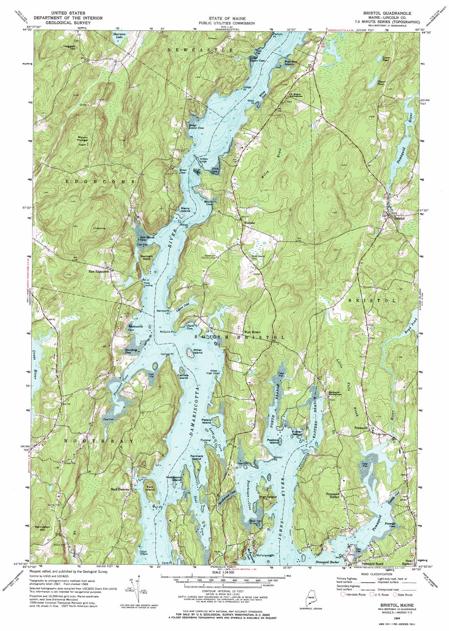
Bristol Topo Map Maine
To zoom in, hover over the map of Bristol
USGS Topo Quad 43069h5 - 1:24,000 scale
| Topo Map Name: | Bristol |
| USGS Topo Quad ID: | 43069h5 |
| Print Size: | ca. 21 1/4" wide x 27" high |
| Southeast Coordinates: | 43.875° N latitude / 69.5° W longitude |
| Map Center Coordinates: | 43.9375° N latitude / 69.5625° W longitude |
| U.S. State: | ME |
| Filename: | o43069h5.jpg |
| Download Map JPG Image: | Bristol topo map 1:24,000 scale |
| Map Type: | Topographic |
| Topo Series: | 7.5´ |
| Map Scale: | 1:24,000 |
| Source of Map Images: | United States Geological Survey (USGS) |
| Alternate Map Versions: |
Bristol ME 1969, updated 1974 Download PDF Buy paper map Bristol ME 2000, updated 2001 Download PDF Buy paper map Bristol ME 2011 Download PDF Buy paper map Bristol ME 2014 Download PDF Buy paper map |
1:24,000 Topo Quads surrounding Bristol
Gardiner |
East Pittston |
North Whitefield |
Jefferson |
Union |
Richmond |
Wiscasset |
Damariscotta |
Waldoboro West |
Waldoboro East |
Bath |
Westport |
Bristol |
Louds Island |
Friendship |
Phippsburg |
Boothbay Harbor |
Pemaquid Point |
New Harbor |
Monhegan |
Small Point |
> Back to 43069e1 at 1:100,000 scale
> Back to 43068a1 at 1:250,000 scale
> Back to U.S. Topo Maps home
Bristol topo map: Gazetteer
Bristol: Bars
Eastern Ledge elevation 0m 0′Eastern Ledge elevation 4m 13′
Gall Rock elevation 1m 3′
Glidden Ledge elevation 0m 0′
Kelp Ledge elevation 2m 6′
McFarlands Ledges elevation 0m 0′
Western Ledge elevation 0m 0′
Bristol: Bays
Bradstreet Cove elevation 1m 3′Briar Cove elevation 4m 13′
Burnham Cove elevation 0m 0′
Cavis Cove elevation 0m 0′
Clark Cove elevation 0m 0′
Coombs Cove elevation 0m 0′
Dodge Lower Cove elevation 11m 36′
Dodge Upper Cove elevation 1m 3′
Fitch Cove elevation 0m 0′
Fossetts Cove elevation 0m 0′
Long Cove elevation 0m 0′
Lowes Cove elevation 0m 0′
Mears Cove elevation 0m 0′
Pemaquid Harbor elevation 0m 0′
Pleasant Cove elevation 0m 0′
Poorhouse Cove elevation 0m 0′
Prentiss Cove elevation 1m 3′
Prentiss Cove elevation 1m 3′
Salt Marsh Cove elevation 0m 0′
Seal Cove elevation 0m 0′
Wadsworth Cove elevation 0m 0′
Wiley Cove elevation 0m 0′
Bristol: Capes
Albee High Head elevation 0m 0′Bennett Neck elevation 16m 52′
Carlisle Point elevation 2m 6′
Cavis Point elevation 6m 19′
Dodge Point elevation 1m 3′
Fitch Point elevation 0m 0′
Fort Point elevation 6m 19′
Kelsey Point elevation 0m 0′
Lower Fitch Point elevation 9m 29′
McFarlands Point elevation 9m 29′
McGuire Point elevation 3m 9′
Plummer Point elevation 10m 32′
Sproul Point elevation 3m 9′
Thurston Point elevation 1m 3′
Wentworth Point elevation 0m 0′
Wiley Point elevation 0m 0′
Bristol: Channels
The Narrows elevation 0m 0′Bristol: Dams
Bristol Mills Dam elevation 18m 59′Clark Cove Pond Dam elevation 1m 3′
Bristol: Islands
Carlisle Island elevation 0m 0′Farmers Island elevation 7m 22′
Fort Island elevation 24m 78′
Foster Island elevation 0m 0′
High Island elevation 1m 3′
Hodgsons Island elevation 10m 32′
Merry Island elevation 0m 0′
Miller Island elevation 2m 6′
Peabow Island elevation 1m 3′
Peters Island elevation 8m 26′
Pleasant Cove Island elevation 3m 9′
Prentiss Island elevation 0m 0′
Bristol: Lakes
Lower Pond elevation 31m 101′Upper Pond elevation 36m 118′
Bristol: Parks
Colonial Pemaquid State Historic Site elevation 5m 16′Dodge Point Preserve elevation 27m 88′
Kitzi-Colby Preserve elevation 36m 118′
Bristol: Populated Places
Back Narrows elevation 20m 65′Bristol elevation 22m 72′
East Edgecomb elevation 18m 59′
Pemaquid elevation 19m 62′
Pemaquid (historical) elevation 19m 62′
Pemaquid Harbor elevation 47m 154′
Pools Landing elevation 10m 32′
Walpole elevation 41m 134′
West Bristol elevation 52m 170′
Bristol: Reservoirs
Biscay Pond elevation 22m 72′Clark Cove Pond elevation 1m 3′
Bristol: Streams
Eastern Branch Johns River elevation 0m 0′Little Falls Brook elevation 13m 42′
North Branch Johns River elevation 0m 0′
Pemaquid River elevation 3m 9′
Wiley Brook elevation 3m 9′
Bristol: Summits
Haggett Hill elevation 73m 239′Kenniston Hill elevation 87m 285′
Mount Hunger elevation 83m 272′
Bristol digital topo map on disk
Buy this Bristol topo map showing relief, roads, GPS coordinates and other geographical features, as a high-resolution digital map file on DVD:
Maine, New Hampshire, Rhode Island & Eastern Massachusetts
Buy digital topo maps: Maine, New Hampshire, Rhode Island & Eastern Massachusetts