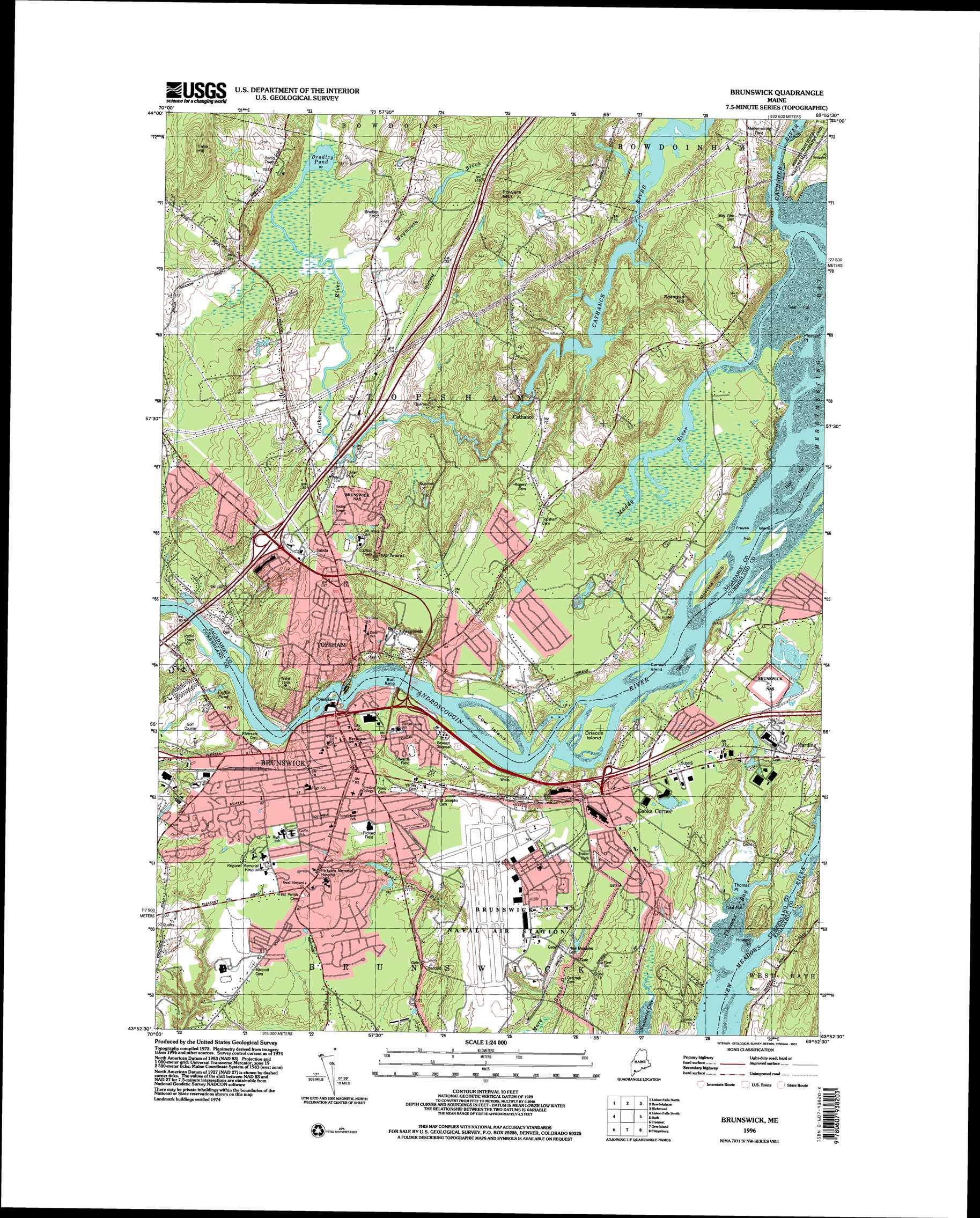
Brunswick Topo Map Maine
To zoom in, hover over the map of Brunswick
USGS Topo Quad 43069h8 - 1:24,000 scale
| Topo Map Name: | Brunswick |
| USGS Topo Quad ID: | 43069h8 |
| Print Size: | ca. 21 1/4" wide x 27" high |
| Southeast Coordinates: | 43.875° N latitude / 69.875° W longitude |
| Map Center Coordinates: | 43.9375° N latitude / 69.9375° W longitude |
| U.S. State: | ME |
| Filename: | o43069h8.jpg |
| Download Map JPG Image: | Brunswick topo map 1:24,000 scale |
| Map Type: | Topographic |
| Topo Series: | 7.5´ |
| Map Scale: | 1:24,000 |
| Source of Map Images: | United States Geological Survey (USGS) |
| Alternate Map Versions: |
Brunswick ME 1980, updated 1980 Download PDF Buy paper map Brunswick ME 1980, updated 1984 Download PDF Buy paper map Brunswick ME 1980, updated 1984 Download PDF Buy paper map Brunswick ME 1996, updated 2001 Download PDF Buy paper map Brunswick ME 2011 Download PDF Buy paper map Brunswick ME 2014 Download PDF Buy paper map |
1:24,000 Topo Quads surrounding Brunswick
Lake Auburn East |
Monmouth |
Purgatory |
Gardiner |
East Pittston |
Lewiston |
Lisbon Falls North |
Bowdoinham |
Richmond |
Wiscasset |
North Pownal |
Lisbon Falls South |
Brunswick |
Bath |
Westport |
Yarmouth |
Freeport |
Orrs Island |
Phippsburg |
Boothbay Harbor |
Portland East |
South Harpswell |
Bailey Island |
Small Point |
> Back to 43069e1 at 1:100,000 scale
> Back to 43068a1 at 1:250,000 scale
> Back to U.S. Topo Maps home
Brunswick topo map: Gazetteer
Brunswick: Airports
Bradley Field elevation 43m 141′Brunswick Naval Air Station Airport elevation 19m 62′
Memorial Hospital Heliport elevation 24m 78′
Topsham Airfield elevation 37m 121′
Brunswick: Bars
Middle Ground elevation 0m 0′Brunswick: Bays
Thomas Bay elevation 0m 0′Brunswick: Beaches
Thomas Point Beach elevation 1m 3′Brunswick: Bridges
Brunswick-Topsham Bridge elevation 7m 22′Brunswick: Capes
Howard Point elevation 17m 55′Pleasant Point elevation 3m 9′
Thomas Point elevation 1m 3′
Woodward Point elevation 21m 68′
Brunswick: Crossings
Interchange 24 elevation 38m 124′Brunswick: Dams
Brunswick Dam elevation 7m 22′Topsham Dam elevation 7m 22′
Topsham Mill Dam elevation 12m 39′
Brunswick: Islands
Cornish Island elevation 1m 3′Cow Island elevation 3m 9′
Driscoll Island elevation 2m 6′
Freyee Islands elevation 1m 3′
Mustard Island elevation 13m 42′
Brunswick: Lakes
Bradley Pond elevation 28m 91′Coffin Pond elevation 22m 72′
Brunswick: Parks
Edwards Field elevation 12m 39′Federal Street Historic District elevation 18m 59′
Lincoln Street Historic District elevation 19m 62′
Lishness Park elevation 8m 26′
Merrymeeting Field elevation 18m 59′
Pickard Field elevation 23m 75′
Topsham Historic District elevation 6m 19′
Whittier Field elevation 22m 72′
Brunswick: Populated Places
Brunswick elevation 19m 62′Cathance elevation 20m 65′
Cooks Corner elevation 15m 49′
Harding elevation 13m 42′
Linnhaven West elevation 25m 82′
Merrymeeting Trailer Park elevation 17m 55′
Topsham elevation 40m 131′
Brunswick: Post Offices
Brunswick Post Office elevation 20m 65′Brunswick: Reservoirs
Androscoggin River Reservoir elevation 7m 22′Androscoggin River Reservoir elevation 7m 22′
Cathance River Reservoir elevation 2m 6′
Brunswick: Streams
Androscoggin River elevation 0m 0′Cathance River elevation 0m 0′
Muddy River elevation 0m 0′
Weymouth Brook elevation 29m 95′
Brunswick: Summits
Mount Ararat elevation 60m 196′Powers Mountain elevation 63m 206′
Sprague Hill elevation 44m 144′
Tate Hill elevation 109m 357′
Brunswick: Woods
Bowdoin Pines elevation 18m 59′Brunswick digital topo map on disk
Buy this Brunswick topo map showing relief, roads, GPS coordinates and other geographical features, as a high-resolution digital map file on DVD:
Maine, New Hampshire, Rhode Island & Eastern Massachusetts
Buy digital topo maps: Maine, New Hampshire, Rhode Island & Eastern Massachusetts