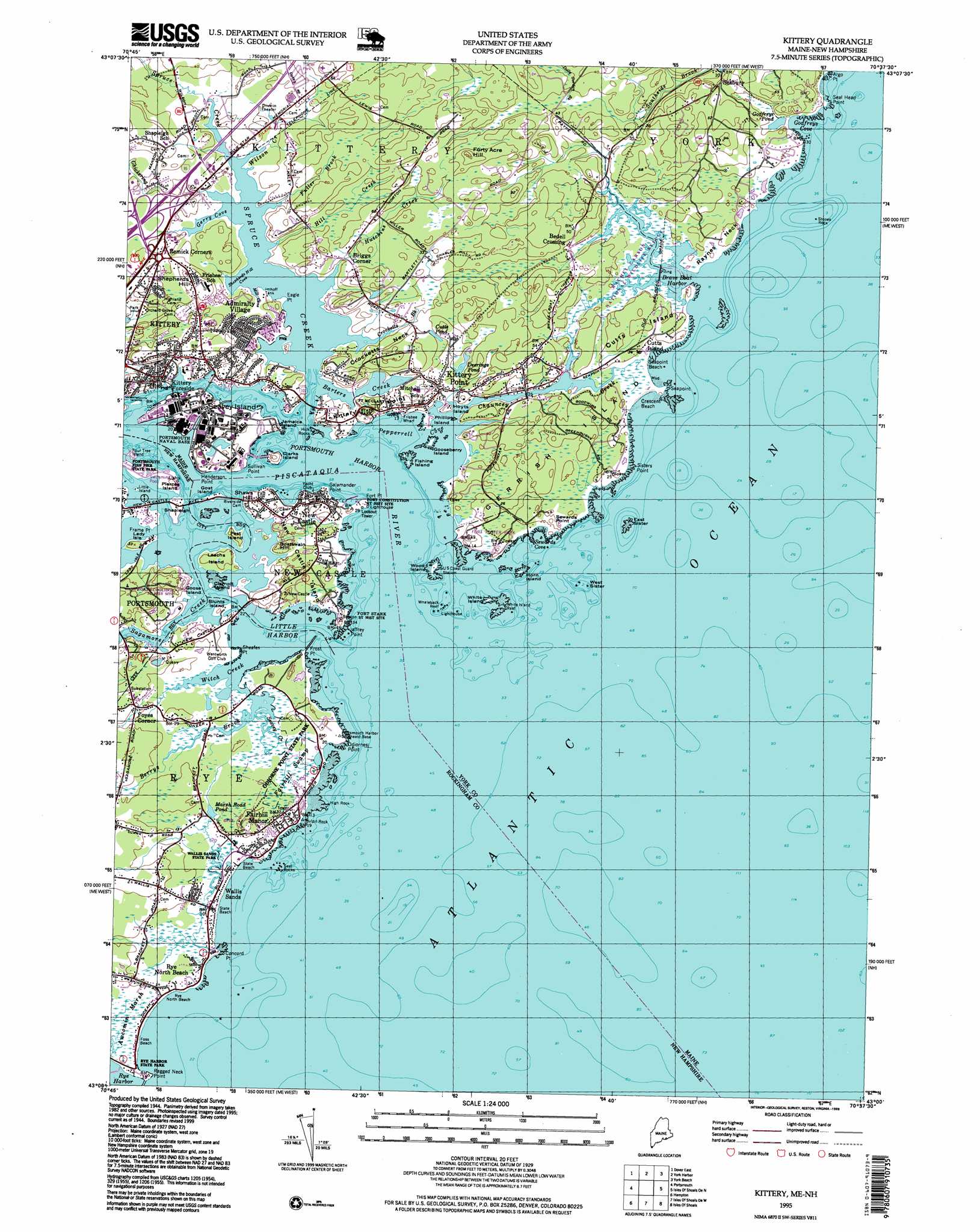
Kittery Topo Map Maine
To zoom in, hover over the map of Kittery
USGS Topo Quad 43070a6 - 1:24,000 scale
| Topo Map Name: | Kittery |
| USGS Topo Quad ID: | 43070a6 |
| Print Size: | ca. 21 1/4" wide x 27" high |
| Southeast Coordinates: | 43° N latitude / 70.625° W longitude |
| Map Center Coordinates: | 43.0625° N latitude / 70.6875° W longitude |
| U.S. States: | ME, NH |
| Filename: | o43070a6.jpg |
| Download Map JPG Image: | Kittery topo map 1:24,000 scale |
| Map Type: | Topographic |
| Topo Series: | 7.5´ |
| Map Scale: | 1:24,000 |
| Source of Map Images: | United States Geological Survey (USGS) |
| Alternate Map Versions: |
Kittery ME 1944 Download PDF Buy paper map Kittery ME 1944, updated 1949 Download PDF Buy paper map Kittery ME 1956, updated 1957 Download PDF Buy paper map Kittery ME 1956, updated 1962 Download PDF Buy paper map Kittery ME 1956, updated 1974 Download PDF Buy paper map Kittery ME 1956, updated 1988 Download PDF Buy paper map Kittery ME 1956, updated 1989 Download PDF Buy paper map Kittery ME 1995, updated 1999 Download PDF Buy paper map Kittery ME 2011 Download PDF Buy paper map Kittery ME 2014 Download PDF Buy paper map |
1:24,000 Topo Quads surrounding Kittery
Rochester |
Somersworth |
North Berwick |
Wells |
Kennebunkport |
Dover West |
Dover East |
York Harbor |
York Beach |
|
Newmarket |
Portsmouth |
Kittery |
||
Hampton |
Isles of Shoals |
|||
Newburyport East |
> Back to 43070a1 at 1:100,000 scale
> Back to 43070a1 at 1:250,000 scale
> Back to U.S. Topo Maps home
Kittery topo map: Gazetteer
Kittery: Bars
East Sister elevation 0m 0′Hicks Rocks elevation 0m 0′
High Rock elevation 0m 0′
Kitts Rocks elevation 0m 0′
Moores Rock elevation 0m 0′
Phillips Rock elevation 0m 0′
Seal Rocks elevation 0m 0′
Stones Rock elevation 0m 0′
West Sister elevation 0m 0′
Whaleback Reef elevation 0m 0′
White Island Reef elevation 0m 0′
Kittery: Bays
Barters Creek elevation 9m 29′Brave Boat Harbor elevation 0m 0′
Gerry Cove elevation 0m 0′
Godfreys Cove elevation 0m 0′
Little Harbor elevation 0m 0′
Mill Cove elevation 0m 0′
Pepperrell Cove elevation 0m 0′
Portsmouth Harbor elevation 0m 0′
Sewards Cove elevation 0m 0′
Shepherds Hill Cove elevation 0m 0′
Kittery: Beaches
Crescent Beach elevation 0m 0′Foss Beach elevation 0m 0′
Rye North Beach elevation 2m 6′
Seapoint Beach elevation 0m 0′
Kittery: Capes
Argo Point elevation 6m 19′Concord Point elevation 0m 0′
Crocketts Neck elevation 15m 49′
Eagle Point elevation 0m 0′
Fort Point elevation 0m 0′
Frame Point elevation 0m 0′
Frost Point elevation 1m 3′
Henderson Point elevation 1m 3′
Jaffrey Point elevation 0m 0′
Kittery Point elevation 13m 42′
Odiornes Point elevation 0m 0′
Ragged Neck Point elevation 0m 0′
Raynes Neck elevation 6m 19′
Salamander Point elevation 7m 22′
Seal Head Point elevation 0m 0′
Seapoint elevation 0m 0′
Sewards Point elevation 8m 26′
Sheafes Point elevation 1m 3′
Sisters Point elevation 1m 3′
Sullivan Point elevation 0m 0′
Kittery: Crossings
Interchange 2 elevation 5m 16′Interchange 3 elevation 6m 19′
Kittery: Harbors
Rye Harbor elevation 1m 3′Kittery: Islands
Blunts Island elevation 4m 13′Clampit Island elevation 1m 3′
Clarks Island elevation 10m 32′
Cutts Island elevation 13m 42′
Fishing Island elevation 0m 0′
Four Tree Island elevation 2m 6′
Gerrish Island elevation 6m 19′
Goat Island elevation 0m 0′
Goose Island elevation 1m 3′
Gooseberry Island elevation 0m 0′
Horn Island elevation 0m 0′
Hoyts Island elevation 10m 32′
Jamaica Island elevation 4m 13′
Lady Isle elevation 7m 22′
Leachs Island elevation 7m 22′
Little Island elevation 0m 0′
New Castle Island elevation 4m 13′
Pest Island elevation 5m 16′
Phillips Island elevation 1m 3′
Pierce Island elevation 4m 13′
Raynes Island elevation 2m 6′
Shapleigh Island elevation 6m 19′
Wattlebury Island elevation 1m 3′
White Island elevation 0m 0′
Wood Island elevation 1m 3′
Kittery: Lakes
Cutts Pond elevation 12m 39′Deerings Pond elevation 9m 29′
Godfreys Pond elevation 1m 3′
Marsh Road Pond elevation 4m 13′
Kittery: Parks
Fort Foster Park elevation 4m 13′Fort McClary State Park elevation 12m 39′
Fort Stark State Historical Site elevation 4m 13′
Odiorne Point State Park elevation 3m 9′
Wallis Sands State Park elevation 0m 0′
Wentworth Coolidge State Historical Site elevation 18m 59′
Kittery: Populated Places
Admiralty Village elevation 6m 19′Bedell Crossing elevation 5m 16′
Briggs Corner elevation 9m 29′
Cutts Island elevation 8m 26′
Fairhill Manor elevation 7m 22′
Foyes Corner elevation 6m 19′
Kittery elevation 6m 19′
Kittery Foreside elevation 9m 29′
Kittery Point elevation 13m 42′
New Castle elevation 7m 22′
Remick Corners elevation 12m 39′
Rye North Beach elevation 0m 0′
Sagamore Grove elevation 9m 29′
Seabury elevation 10m 32′
Seavey Island elevation 4m 13′
Shaws Hill elevation 12m 39′
Shepherds Hill elevation 25m 82′
Wallis Sands elevation 1m 3′
Kittery: Post Offices
New Castle Post Office elevation 6m 19′Kittery: Reservoirs
Imhoff Tank elevation 1m 3′Kittery: Streams
Berrys Brook elevation 0m 0′Chauncey Creek elevation 0m 0′
Chickering Creek elevation 0m 0′
Crocketts Brook elevation 0m 0′
Fuller Brook elevation 3m 9′
Hill Creek elevation 4m 13′
Hutchins Creek elevation 0m 0′
Piscataqua River elevation 0m 0′
Sagamore Creek elevation 0m 0′
Seavey Creek elevation -1m -4′
Spruce Creek elevation 0m 0′
Wilson Creek elevation 1m 3′
Witch Creek elevation 0m 0′
Kittery: Summits
Boatswain Hill elevation 12m 39′Forty Acre Hill elevation 30m 98′
Kittery: Swamps
Fairhill Swamp elevation 1m 3′Kittery digital topo map on disk
Buy this Kittery topo map showing relief, roads, GPS coordinates and other geographical features, as a high-resolution digital map file on DVD:
Maine, New Hampshire, Rhode Island & Eastern Massachusetts
Buy digital topo maps: Maine, New Hampshire, Rhode Island & Eastern Massachusetts