York Harbor Topo Map Maine
To zoom in, hover over the map of York Harbor
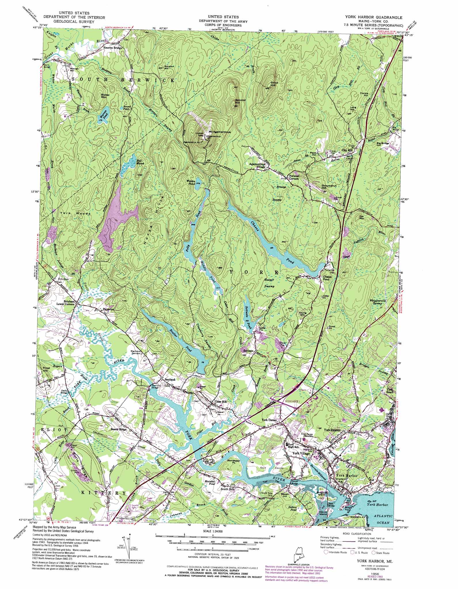
USGS Topo Quad 43070b6 - 1:24,000 scale
| Topo Map Name: | York Harbor |
| USGS Topo Quad ID: | 43070b6 |
| Print Size: | ca. 21 1/4" wide x 27" high |
| Southeast Coordinates: | 43.125° N latitude / 70.625° W longitude |
| Map Center Coordinates: | 43.1875° N latitude / 70.6875° W longitude |
| U.S. State: | ME |
| Filename: | o43070b6.jpg |
| Download Map JPG Image: | York Harbor topo map 1:24,000 scale |
| Map Type: | Topographic |
| Topo Series: | 7.5´ |
| Map Scale: | 1:24,000 |
| Source of Map Images: | United States Geological Survey (USGS) |
| Alternate Map Versions: |
York Harbor ME 1944 Download PDF Buy paper map York Harbor ME 1944 Download PDF Buy paper map York Harbor ME 1956, updated 1958 Download PDF Buy paper map York Harbor ME 1956, updated 1965 Download PDF Buy paper map York Harbor ME 1956, updated 1974 Download PDF Buy paper map York Harbor ME 1956, updated 1990 Download PDF Buy paper map York Harbor ME 1956, updated 1994 Download PDF Buy paper map York Harbor ME 1977, updated 1979 Download PDF Buy paper map York Harbor ME 2011 Download PDF Buy paper map York Harbor ME 2014 Download PDF Buy paper map |
1:24,000 Topo Quads surrounding York Harbor
Milton |
Sanford |
Alfred |
Kennebunk |
Biddeford |
Rochester |
Somersworth |
North Berwick |
Wells |
Kennebunkport |
Dover West |
Dover East |
York Harbor |
York Beach |
|
Newmarket |
Portsmouth |
Kittery |
||
Hampton |
Isles of Shoals |
> Back to 43070a1 at 1:100,000 scale
> Back to 43070a1 at 1:250,000 scale
> Back to U.S. Topo Maps home
York Harbor topo map: Gazetteer
York Harbor: Bars
Black Rocks elevation 0m 0′Millbury Ledge elevation 0m 0′
York Harbor: Bays
Lobster Cove elevation 1m 3′North Basin elevation 0m 0′
South Basin elevation 31m 101′
York Harbor elevation 0m 0′
York Harbor: Bridges
Big Bridge elevation 24m 78′Cooks Bridge elevation 0m 0′
Dorrs Bridge elevation 24m 78′
New Bridge elevation 0m 0′
Rices Bridge elevation 0m 0′
Wiggley Bridge elevation 0m 0′
Wilson Bridge elevation 36m 118′
York Harbor: Capes
Fort Point elevation 0m 0′Fort Point elevation 0m 0′
Goodrich Point elevation 0m 0′
Ramshead Point elevation 11m 36′
Stage Neck elevation 10m 32′
Western Point elevation 4m 13′
York Harbor: Channels
Ramshead Ditch elevation 0m 0′York Harbor: Crossings
Interchange 1 elevation 13m 42′Interchange 4 elevation 7m 22′
York Harbor: Dams
Boulter Dam elevation 23m 75′Chases Pond Dam elevation 46m 150′
Folly Pond Dam elevation 75m 246′
Middle Pond Dam elevation 68m 223′
Scituate Pond Dam elevation 49m 160′
York Harbor: Islands
Bragdon Island elevation 6m 19′Harris Island elevation 3m 9′
Rocks Nose elevation 0m 0′
York Harbor: Lakes
Barrells Millpond elevation 0m 0′Bridges Ice Pond (historical) elevation 12m 39′
Indian Pond elevation 17m 55′
Round Pond elevation 59m 193′
Warren Pond elevation 53m 173′
Welchs Pond elevation 85m 278′
York Harbor: Parks
Harmon Park elevation 14m 45′Mount Agamenticus Park elevation 206m 675′
York Historic District elevation 22m 72′
York Harbor: Populated Places
Agamenticus Village elevation 67m 219′Beech Ridge elevation 27m 88′
Brickyard Landing (historical) elevation 12m 39′
Brixham elevation 32m 104′
Brixham Lower Corners elevation 6m 19′
Cain Crest Trailer Park elevation 22m 72′
Chases Pond elevation 49m 160′
Cider Hill elevation 32m 104′
Clay Hill elevation 41m 134′
Emerys Bridge elevation 32m 104′
Foristall Corners elevation 65m 213′
Payneton elevation 17m 55′
Scituate elevation 56m 183′
Scotland elevation 12m 39′
South Side elevation 12m 39′
York Corner elevation 18m 59′
York Harbor elevation 14m 45′
York Heights elevation 22m 72′
York Village elevation 24m 78′
York Harbor: Post Offices
York Harbor Post Office elevation 13m 42′York Village Post Office elevation 20m 65′
York Harbor: Reservoirs
Blaisdell Pond elevation 11m 36′Boulter Pond elevation 23m 75′
Chases Pond elevation 46m 150′
Folly Pond elevation 75m 246′
Middle Pond elevation 68m 223′
Scituate Pond elevation 49m 160′
York Harbor: Ridges
Cutts Ridge elevation 40m 131′York Harbor: Streams
Barrell Farm Brook elevation 3m 9′Bass Cove Creek elevation 0m 0′
Bennett Brook elevation 29m 95′
Cider Hill Creek elevation 0m 0′
Clay Hill Brook elevation 20m 65′
Cutts Ridge Brook elevation 0m 0′
Dolly Gordon Brook elevation 6m 19′
Hoopers Brook elevation 27m 88′
Johnson Brook elevation 12m 39′
Josias Brook elevation 41m 134′
Knights Brook elevation 25m 82′
Libby Brook elevation 3m 9′
Little River elevation 1m 3′
Little River elevation 1m 3′
Macintire Junkins Brook elevation 4m 13′
Moulton Brook elevation 4m 13′
Rogers Brook elevation 0m 0′
Smelt Brook elevation 0m 0′
Southside Brook elevation 3m 9′
Warren Brook elevation 29m 95′
Whites Marsh Brook elevation 21m 68′
York River elevation 0m 0′
York Harbor: Summits
Bickel Mountain elevation 86m 282′Big Bridge Hill elevation 41m 134′
Cat Mountain elevation 67m 219′
Cockle Hill elevation 49m 160′
Frost Hill elevation 39m 127′
Groundnut Hill elevation 93m 305′
Horse Hills elevation 98m 321′
Long Hill elevation 68m 223′
Mount Agamenticus elevation 210m 688′
Norman Hill elevation 103m 337′
Paint Hill elevation 55m 180′
Second Hill elevation 167m 547′
Sewall Hill elevation 26m 85′
Third Hill elevation 159m 521′
Warren Hill elevation 43m 141′
Young Hill elevation 67m 219′
York Harbor: Swamps
Bell Marsh elevation 39m 127′Braceys Swamp elevation 65m 213′
Bridges Swamp elevation 16m 52′
Cefalo Swamp elevation 11m 36′
Cranberry Swamp elevation 32m 104′
Hooper Swamp elevation 59m 193′
Hoopers Swamp elevation 47m 154′
Whippoorwill Swamp elevation 17m 55′
York Harbor: Trails
Shore Path Trail elevation 3m 9′York Harbor: Woods
York Woods elevation 72m 236′York Harbor digital topo map on disk
Buy this York Harbor topo map showing relief, roads, GPS coordinates and other geographical features, as a high-resolution digital map file on DVD:
Maine, New Hampshire, Rhode Island & Eastern Massachusetts
Buy digital topo maps: Maine, New Hampshire, Rhode Island & Eastern Massachusetts