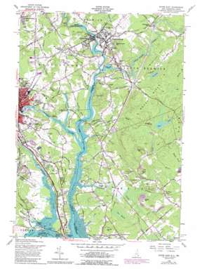
Dover East Topo Map Maine
To zoom in, hover over the map of Dover East
USGS Topo Quad 43070b7 - 1:24,000 scale
| Topo Map Name: | Dover East |
| USGS Topo Quad ID: | 43070b7 |
| Print Size: | ca. 21 1/4" wide x 27" high |
| Southeast Coordinates: | 43.125° N latitude / 70.75° W longitude |
| Map Center Coordinates: | 43.1875° N latitude / 70.8125° W longitude |
| U.S. States: | ME, NH |
| Filename: | o43070b7.jpg |
| Download Map JPG Image: | Dover East topo map 1:24,000 scale |
| Map Type: | Topographic |
| Topo Series: | 7.5´ |
| Map Scale: | 1:24,000 |
| Source of Map Images: | United States Geological Survey (USGS) |
| Alternate Map Versions: |
Dover East NH 1956, updated 1958 Download PDF Buy paper map Dover East NH 1956, updated 1965 Download PDF Buy paper map Dover East NH 1956, updated 1974 Download PDF Buy paper map Dover East NH 1956, updated 1989 Download PDF Buy paper map Dover East NH 1956, updated 1989 Download PDF Buy paper map Dover East NH 1977, updated 1979 Download PDF Buy paper map Dover East NH 2012 Download PDF Buy paper map Dover East NH 2015 Download PDF Buy paper map |
1:24,000 Topo Quads surrounding Dover East
> Back to 43070a1 at 1:100,000 scale
> Back to 43070a1 at 1:250,000 scale
> Back to U.S. Topo Maps home
Dover East topo map: Gazetteer
Dover East: Airports
Littlebrook Air Park elevation 34m 111′Wentworth-Douglass Heliport elevation 47m 154′
Dover East: Bays
Boston Harbor elevation 0m 0′Pomeroy Cove elevation 1m 3′
Royalls Cove elevation 0m 0′
Dover East: Bridges
Scammel Bridge elevation 0m 0′Dover East: Capes
Cedar Point elevation 1m 3′Clements Point elevation 4m 13′
Dover Point elevation 20m 65′
Dover East: Channels
Lower Narrows elevation 4m 13′Upper Narrows elevation 1m 3′
Dover East: Crossings
Interchange 6 elevation 6m 19′Dover East: Dams
Cocheco River Number 2 Dam elevation 7m 22′Great Works Dam elevation 19m 62′
Little Brook Dam elevation 13m 42′
Mill Dam elevation 42m 137′
Rollinsford Dam elevation 19m 62′
Salmon Falls Dam elevation 0m 0′
Dover East: Lakes
Cox Pond elevation 33m 108′York Pond elevation 52m 170′
Dover East: Parks
Bellamy Preserve elevation 4m 13′Bellamy River Access Wildlife Preserve elevation 5m 16′
Cochecho River Walk and Canoe Launch elevation 3m 9′
Fish Ladder Park elevation 13m 42′
Frost Tufts Park and Ballpark elevation 15m 49′
Garrison Hill Park elevation 85m 278′
Guppey Park elevation 28m 91′
Henry Law Park elevation 4m 13′
Immigrant Park elevation 20m 65′
Maglaras Park elevation 15m 49′
Salmon Falls Mill Historic District elevation 18m 59′
Vaughan Woods State Park elevation 38m 124′
Dover East: Populated Places
Agamenticus Station elevation 30m 98′Crams Corner elevation 12m 39′
Crocketts Crossing elevation 41m 134′
Cummings elevation 37m 121′
Dover elevation 19m 62′
East Eliot elevation 15m 49′
Eliot elevation 9m 29′
Gould Corner elevation 24m 78′
Great Works elevation 26m 85′
Jewett elevation 30m 98′
Kennard Corner elevation 24m 78′
Oldfields elevation 46m 150′
Rollinsford elevation 32m 104′
Rollinsford Station elevation 37m 121′
Rosemary elevation 38m 124′
South Berwick elevation 34m 111′
Dover East: Post Offices
Eliot Post Office elevation 10m 32′Rollinsford Post Office elevation 33m 108′
Dover East: Reservoirs
Cocheco River Reservoir elevation 7m 22′Great Works River Reservoir elevation 19m 62′
Little Brook elevation 13m 42′
Salmon Falls River Reservoir elevation 19m 62′
Salmon Falls River Reservoir elevation 0m 0′
Stoney Brook elevation 42m 137′
Dover East: Streams
Bellamy River elevation 0m 0′Canney Brook elevation 4m 13′
Cocheco River elevation 0m 0′
Driscoll Brook elevation 7m 22′
Emerson Brook elevation 9m 29′
Fresh Creek elevation 0m 0′
Garvin Brook elevation 3m 9′
Great Creek elevation 5m 16′
Great Works River elevation 2m 6′
Hamilton Brook elevation 5m 16′
Little Brook elevation 4m 13′
Lord Brook elevation 6m 19′
Lovers Brook elevation 20m 65′
Quamphegan Brook elevation 0m 0′
Rollins Brook elevation 14m 45′
Salmon Falls River elevation 0m 0′
Shapleigh Old Mill Pond elevation 0m 0′
Shoreys Brook elevation 0m 0′
Sligo Brook elevation 5m 16′
Sturgeon Creek elevation 0m 0′
Twombly Brook elevation 23m 75′
Varney Brook elevation 3m 9′
Dover East: Summits
Cummings Hill elevation 70m 229′Fletcher Hill elevation 65m 213′
Garrison Hill elevation 89m 291′
Great Hill elevation 87m 285′
Huckleberry Hill elevation 41m 134′
Indigo Hill elevation 55m 180′
Marsh Hill elevation 46m 150′
Mount Pleasant elevation 57m 187′
Powderhouse Hill elevation 87m 285′
Raitt Hill elevation 74m 242′
Rocky Hills elevation 69m 226′
Slate Hill elevation 27m 88′
Sunset Hill elevation 44m 144′
Swasey Hill elevation 69m 226′
Third Hill elevation 104m 341′
Witchtrot Hill elevation 55m 180′
Dover East: Swamps
The Heath elevation 4m 13′Dover East digital topo map on disk
Buy this Dover East topo map showing relief, roads, GPS coordinates and other geographical features, as a high-resolution digital map file on DVD:
Maine, New Hampshire, Rhode Island & Eastern Massachusetts
Buy digital topo maps: Maine, New Hampshire, Rhode Island & Eastern Massachusetts


