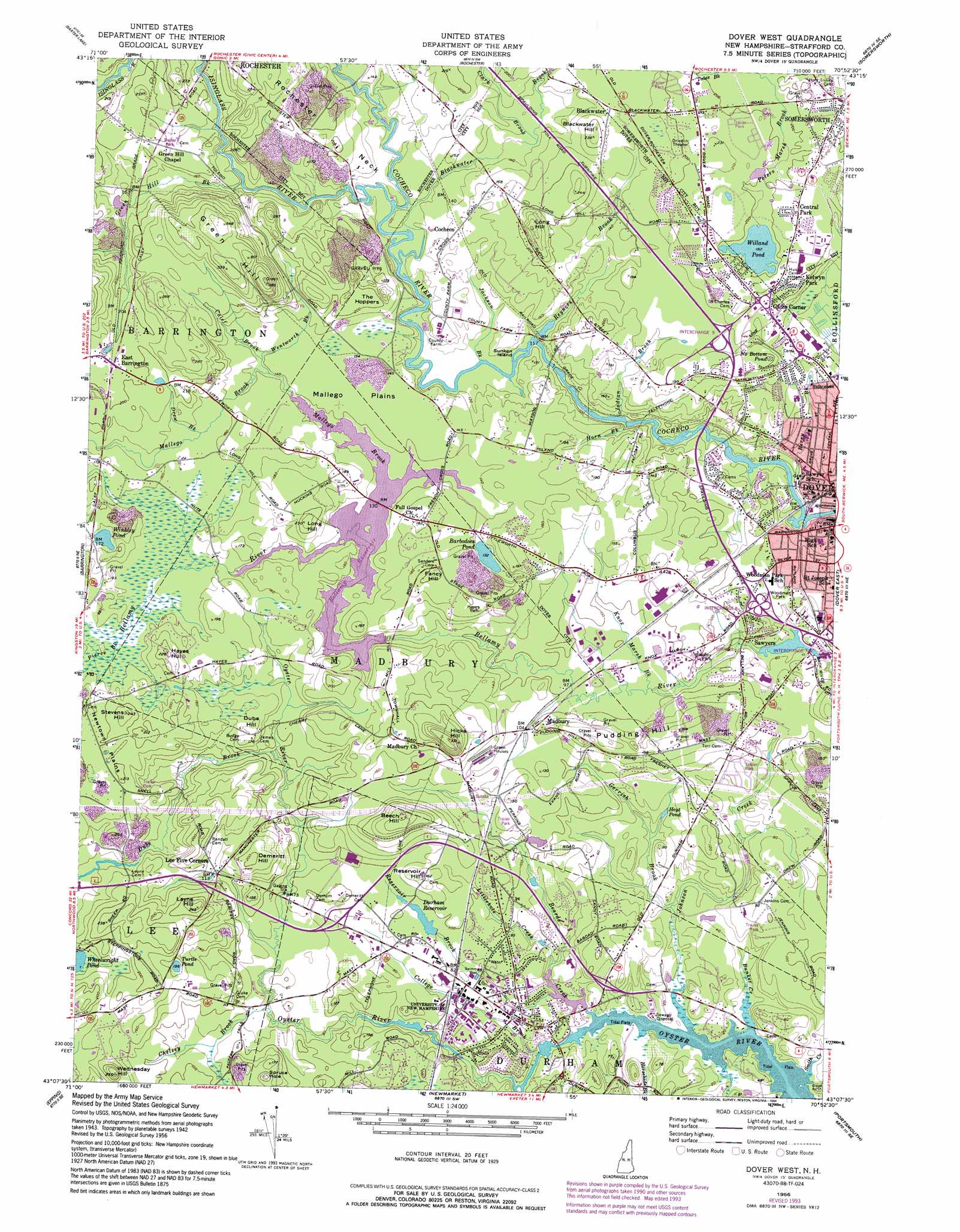
Dover West Topo Map New Hampshire
To zoom in, hover over the map of Dover West
USGS Topo Quad 43070b8 - 1:24,000 scale
| Topo Map Name: | Dover West |
| USGS Topo Quad ID: | 43070b8 |
| Print Size: | ca. 21 1/4" wide x 27" high |
| Southeast Coordinates: | 43.125° N latitude / 70.875° W longitude |
| Map Center Coordinates: | 43.1875° N latitude / 70.9375° W longitude |
| U.S. State: | NH |
| Filename: | o43070b8.jpg |
| Download Map JPG Image: | Dover West topo map 1:24,000 scale |
| Map Type: | Topographic |
| Topo Series: | 7.5´ |
| Map Scale: | 1:24,000 |
| Source of Map Images: | United States Geological Survey (USGS) |
| Alternate Map Versions: |
Dover West NH 1956, updated 1958 Download PDF Buy paper map Dover West NH 1956, updated 1967 Download PDF Buy paper map Dover West NH 1956, updated 1974 Download PDF Buy paper map Dover West NH 1956, updated 1978 Download PDF Buy paper map Dover West NH 1956, updated 1989 Download PDF Buy paper map Dover West NH 1956, updated 1989 Download PDF Buy paper map Dover West NH 1956, updated 1989 Download PDF Buy paper map Dover West NH 1956, updated 1994 Download PDF Buy paper map Dover West NH 1956, updated 1994 Download PDF Buy paper map Dover West NH 2012 Download PDF Buy paper map Dover West NH 2015 Download PDF Buy paper map |
1:24,000 Topo Quads surrounding Dover West
Alton |
Farmington |
Milton |
Sanford |
Alfred |
Parker Mountain |
Baxter Lake |
Rochester |
Somersworth |
North Berwick |
Northwood |
Barrington |
Dover West |
Dover East |
York Harbor |
Mount Pawtuckaway |
Epping |
Newmarket |
Portsmouth |
Kittery |
Sandown |
Kingston |
Hampton |
> Back to 43070a1 at 1:100,000 scale
> Back to 43070a1 at 1:250,000 scale
> Back to U.S. Topo Maps home
Dover West topo map: Gazetteer
Dover West: Basins
Spruce Hole elevation 40m 131′The Hoppers elevation 37m 121′
Dover West: Bridges
County Farm Bridge elevation 36m 118′Dover West: Capes
Rochester Neck elevation 60m 196′Dover West: Crossings
Interchange 7 elevation 23m 75′Interchange 8 elevation 29m 95′
Interchange 9 elevation 55m 180′
Dover West: Dams
Bellamy Reservoir Dam elevation 41m 134′Oyster River Dam elevation 6m 19′
Reservoir Dam elevation 25m 82′
Upper Mill Dam elevation 21m 68′
Waldron Dam elevation 29m 95′
Water Works Dam elevation 16m 52′
Dover West: Flats
Mallego Plains elevation 44m 144′Newtown Plains elevation 57m 187′
Dover West: Islands
Sunken Island elevation 32m 104′Dover West: Lakes
Barbadoes Pond elevation 42m 137′Hoyt Pond elevation 17m 55′
No Bottom Pond elevation 61m 200′
Turtle Pond elevation 49m 160′
Willand Pond elevation 55m 180′
Winkley Pond elevation 54m 177′
Dover West: Parks
Bellamy Park elevation 24m 78′Durham Historic District elevation 13m 42′
Hilltop Fun Center elevation 61m 200′
Long Hill Memorial Park elevation 62m 203′
New England Center elevation 19m 62′
Tuttle Square elevation 23m 75′
Woodman Park elevation 30m 98′
Woodman School Park elevation 32m 104′
Dover West: Populated Places
Blackwater elevation 52m 170′Central Park elevation 63m 206′
Cocheco elevation 47m 154′
Durham elevation 15m 49′
Gates Corner elevation 60m 196′
Kelwyn Park elevation 63m 206′
Lee Five Corners elevation 36m 118′
Madbury elevation 36m 118′
Sawyers elevation 21m 68′
Dover West: Post Offices
Dover Post Office elevation 18m 59′Durham Post Office elevation 19m 62′
Dover West: Reservoirs
Bellamy Reservoir elevation 41m 134′Bellamy River Reservoir elevation 21m 68′
Durham Reservoir elevation 25m 82′
Oyster River Reservoir elevation 16m 52′
Oyster River Reservoir elevation 6m 19′
Dover West: Streams
Beards Creek elevation 0m 0′Berry Brook elevation 12m 39′
Blackwater Brook elevation 32m 104′
Bunker Creek elevation 5m 16′
Calef Brook elevation 42m 137′
Chelsey Brook elevation 18m 59′
Clark Brook elevation 40m 131′
College Brook elevation 5m 16′
Drew Brook elevation 48m 157′
Dube Brook elevation 34m 111′
Gerrish Brook elevation 6m 19′
Green Hill Brook elevation 36m 118′
Hamel Brook elevation 5m 16′
Horn Brook elevation 22m 72′
Horsehide Brook elevation 1m 3′
Indian Brook elevation 28m 91′
Isinglass River elevation 35m 114′
Jackson Brook elevation 32m 104′
Johnson Creek elevation 5m 16′
Kelly Brook elevation 27m 88′
Knox Marsh Brook elevation 25m 82′
Littlehole Creek elevation 6m 19′
Mallego Brook elevation 41m 134′
Pierce Brook elevation 48m 157′
Reservoir Brook elevation 3m 9′
Reyners Brook elevation 36m 118′
Smith Creek elevation 6m 19′
Wentworth Brook elevation 42m 137′
Dover West: Summits
Beech Hill elevation 86m 282′Blackwater Hill elevation 70m 229′
Demeritt Hill elevation 59m 193′
Dube Hill elevation 50m 164′
Fancy Hill elevation 61m 200′
Green Hill elevation 112m 367′
Hayes Hill elevation 67m 219′
Hicks Hill elevation 97m 318′
Layne Hill elevation 76m 249′
Long Hill elevation 90m 295′
Long Hill elevation 69m 226′
Pudding Hill elevation 55m 180′
Reservoir Hill elevation 49m 160′
Stevens Hill elevation 73m 239′
Wednesday Hill elevation 72m 236′
Dover West digital topo map on disk
Buy this Dover West topo map showing relief, roads, GPS coordinates and other geographical features, as a high-resolution digital map file on DVD:
Maine, New Hampshire, Rhode Island & Eastern Massachusetts
Buy digital topo maps: Maine, New Hampshire, Rhode Island & Eastern Massachusetts